![](/images/other/stat-length.png)
![Trail Walking Hyères - Porquerolles - Photo](https://media.geolcdn.com/t/1900/400/f3396ed8-c944-4ad3-a27c-027176be03ea.heic&format=pjpeg&maxdim=2)
Porquerolles
pauldurand
User
![Length](/images/other/stat-length.png)
![Max alt](https://static1.geolcdn.com/siteimages/upload/files/1508320355ic_sort_altitude_max_24dp.png)
![Uphill gradient](https://static1.geolcdn.com/siteimages/upload/files/1508320355ic_sort_den_pos_24dp.png)
![Km-Effort](/images/other/stat-length.png)
![Min alt](https://static1.geolcdn.com/siteimages/upload/files/1508320355ic_sort_altitude_min_24dp.png)
![Downhill gradient](https://static1.geolcdn.com/siteimages/upload/files/1508320355ic_sort_den_neg_24dp.png)
![Boucle](https://static1.geolcdn.com/siteimages/upload/files/16400158638029165_repeat_loop_refresh_sync_direction_icon.png)
![Walking](https://static1.geolcdn.com/sitytour/trail-icons/101.png)
2h40
Difficulty : Medium
![Scan this QR Code to open this trail in the SityTrail application](https://capi.geolives.com/qq0zvz2zws4bq2lad0pu/sitytour/trails/2941649/qr.png?size=200)
FREE GPS app for hiking
About
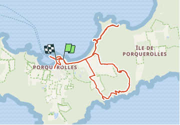
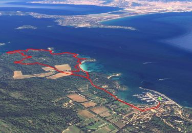
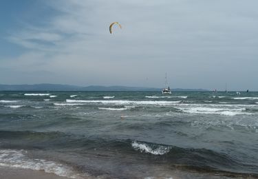
Trail Walking of 11.5 km to be discovered at Provence-Alpes-Côte d'Azur, Var, Hyères. This trail is proposed by pauldurand.
Description
Départ de l'arrivée du bateau, direction PLAGE NOTRE DAME, puis en longeant les vignes tourner à droite dans les vignes jusqu'au sud de l'île -
puis retour vers les sémaphore, pour rejoindre le premier chemin que nous avions pris le matin jusqu'au carrefour de l'ALYCASTRE
Puis retour par la même route jusqu'au bateau (Retour 16h impératif)
Positioning
Comments
Trails nearby
![Trail Walking Hyères - SityTrail - presquile-de-giens-cote-est-france - Photo](https://media.geolcdn.com/t/375/260/111e178c-db2d-4519-839d-89c97a7ddc38.jpg&format=jpg&maxdim=2)
![Walking Walking](https://static1.geolcdn.com/sitytour/trail-icons/101.png)
Walking
![](/images/other/stat-length.png)
![](https://static1.geolcdn.com/siteimages/upload/files/16400158638029165_repeat_loop_refresh_sync_direction_icon.png)
![Trail Walking Hyères - Tour Fondue - La Madrague - Photo](https://media.geolcdn.com/t/375/260/ext.jpg?maxdim=2&url=https%3A%2F%2Fservices.sitytrail.com%2FGeolivesWS%2FDownloadMedia.ashx%3FTrailID%3D408792%26Media%3Dfix__20150414183437.jpg)
![Walking Walking](https://static1.geolcdn.com/sitytour/trail-icons/101.png)
Walking
![](/images/other/stat-length.png)
![](https://static1.geolcdn.com/siteimages/upload/files/16400158638029165_repeat_loop_refresh_sync_direction_icon.png)
![Trail Mountain bike Hyères - 83 porquerolles - Photo](https://media.geolcdn.com/t/375/260/f1373d3a-3c7f-4956-b2e9-fceb4ddd92ad.jpg&format=jpg&maxdim=2)
![Mountain bike Mountain bike](https://static1.geolcdn.com/sitytour/trail-icons/202.png)
Mountain bike
![](/images/other/stat-length.png)
![](https://static1.geolcdn.com/siteimages/upload/files/16400158638029165_repeat_loop_refresh_sync_direction_icon.png)
![Trail Walking Hyères - Presqu'île de Grenoble Est 2/10/21 - Photo](https://media.geolcdn.com/t/375/260/ext.jpg?maxdim=2&url=https%3A%2F%2Fstatic1.geolcdn.com%2Fsiteimages%2Fupload%2Ffiles%2F1553511878bg_sport_marche.png)
![Walking Walking](https://static1.geolcdn.com/sitytour/trail-icons/101.png)
Walking
![](/images/other/stat-length.png)
![](https://static1.geolcdn.com/siteimages/upload/files/16400158638029165_repeat_loop_refresh_sync_direction_icon.png)
![Trail Walking Hyères - Tour de la presqu'île de Giens est - Cap Esterel - Photo](https://media.geolcdn.com/t/375/260/cc04081d-d0da-465a-bbda-9226021fb9fc.jpg&format=jpg&maxdim=2)
![Walking Walking](https://static1.geolcdn.com/sitytour/trail-icons/101.png)
Walking
![](/images/other/stat-length.png)
![](https://static1.geolcdn.com/siteimages/upload/files/16400158638029165_repeat_loop_refresh_sync_direction_icon.png)
![Trail On foot Hyères - Ile de Porquerolles côté ouest 24-05-2024 - Photo](https://media.geolcdn.com/t/375/260/8f5bfa92-e8a3-4f67-8a3d-7eea9ec0a1e3.jpg&format=jpg&maxdim=2)
![On foot On foot](https://static1.geolcdn.com/sitytour/trail-icons/100.png)
On foot
![](/images/other/stat-length.png)
![](https://static1.geolcdn.com/siteimages/upload/files/16400158638029165_repeat_loop_refresh_sync_direction_icon.png)
![Trail Walking Hyères - Ile de Porquerolles - Photo](https://media.geolcdn.com/t/375/260/a1c0ccd3-737f-48da-a3f1-3d7559d679bf.jpg&format=jpg&maxdim=2)
![Walking Walking](https://static1.geolcdn.com/sitytour/trail-icons/101.png)
Walking
![](/images/other/stat-length.png)
![](https://static1.geolcdn.com/siteimages/upload/files/16400158638029165_repeat_loop_refresh_sync_direction_icon.png)
![Trail Walking Hyères - Tour de la Presqu'île de Giens-05-04-23 - Photo](https://media.geolcdn.com/t/375/260/14c5260e-a78f-4087-82e6-20738fb1aa89.jpg&format=jpg&maxdim=2)
![Walking Walking](https://static1.geolcdn.com/sitytour/trail-icons/101.png)
Walking
![](/images/other/stat-length.png)
![](https://static1.geolcdn.com/siteimages/upload/files/16400158638029165_repeat_loop_refresh_sync_direction_icon.png)
![Trail Walking Hyères - Presqu'île de Giens est-03-06-22 - Photo](https://media.geolcdn.com/t/375/260/c844f258-4d5d-4c60-bd4a-d27d3e19e122.jpg&format=jpg&maxdim=2)
![Walking Walking](https://static1.geolcdn.com/sitytour/trail-icons/101.png)
Walking
![](/images/other/stat-length.png)
![](https://static1.geolcdn.com/siteimages/upload/files/16400158638029165_repeat_loop_refresh_sync_direction_icon.png)