Trail  Sospel - 2021-09-18_15h51m29_sospel-cime-de-liniere - Photo

2021-09-18_15h51m29_sospel-cime-de-liniere

© OpenStreetMap contributors
Length
Length
16.7 km
Max alt
Max alt
1370 m
Uphill gradient
Uphill gradient
1116 m
Km-Effort
Km-Effort  
32 km
Min alt
Min alt
345 m
Downhill gradient
Downhill gradient
1116 m
Boucle
Boucle
Yes
Creation date :
2021-09-18 13:51:29.468
Updated on :
2021-09-18 13:51:32.756

(0 Reviews)


Scan this QR Code to open this trail in the SityTrail application

FREE GPS app for hiking

Logo SityTrail SityTrail

IGN / Geographical institutes

Download SityTrail from the App Store Download SityTrail from Google Play

Logo SityTrail SityTrail World

The world is yours!

Download SityTrail from the App Store Download SityTrail from Google Play Download SityTrail on Huawei AppGallery

About

Trail of 16.7 km to be discovered at Provence-Alpes-Côte d'Azur, Maritime Alps, Sospel. This trail is proposed by sylvainstaels.

Description

Traverser la Bevéra - prendre le Bd Charles Degaulle - A la B71 prendre le GR52 jusqu'à la baisse de Linière alt 1345m - quitter le GR52 pour la cime de Linière alt 1368m distance7,2km D 1016m.
Retour par la pointe calvièra alt 1108m - la croix de Réoune 1036m - A la B78 suivre le GR52a - Arrivée Sospel 17km pour D 1100m

Elevation profile

Positioning

Country:
France
Region :
Provence-Alpes-Côte d'Azur
Department/Province :
Maritime Alps
Municipality :
Sospel
Location:
Unknown
Start:(Dec)
Start:(UTM)
375199 ; 4859512 (32T) N.

Trails nearby

Trail On foot Sospel - Circuit du Cuore - Photo
On foot
GUIDE+

On foot

Medium
Sospel, Provence-Alpes-Côte d'Azur, Maritime Alps, France
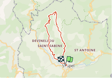
13.7 km | 26 km-effort
5h 54min
Yes
Trail On foot Sospel - Tour du mont Grazian - Photo
On foot
GUIDE+

On foot

Easy
Sospel, Provence-Alpes-Côte d'Azur, Maritime Alps, France
12.1 km | 19.3 km-effort
4h 23min
Yes
Trail On foot Sospel - Boucle du mont Agaisen - Photo
On foot
GUIDE+

On foot

Easy
Sospel, Provence-Alpes-Côte d'Azur, Maritime Alps, France
8.7 km | 14.1 km-effort
3h 12min
Yes
Trail Walking Sospel - Sospel - Le Mont Agaisen - Photo
Walking
GUIDE
Orcal37

Walking

Medium
Sospel, Provence-Alpes-Côte d'Azur, Maritime Alps, France
9.8 km | 15.7 km-effort
3h 5min
Yes
Trail Walking Sospel - 06 - Moyen Pays - 46. Tour du Mont Grazian - Photo
Walking
kamell21

Walking

Medium
(1)
Sospel, Provence-Alpes-Côte d'Azur, Maritime Alps, France
11.9 km | 19 km-effort
Unknown
Yes
Trail Walking Sospel - Sospel à Airole - Photo
Walking
patsure

Walking

Medium
Sospel, Provence-Alpes-Côte d'Azur, Maritime Alps, France
16.1 km | 23 km-effort
4h 58min
No
Trail Walking Castillon - Castillon : Mt Ours - Photo
Walking
ETMU5496

Walking

Medium
Castillon, Provence-Alpes-Côte d'Azur, Maritime Alps, France
16.7 km | 29 km-effort
4h 22min
Yes
Trail Walking Castillon - Du col de Castillon pour la crête du Mt Razet - Photo
Walking
GrouGary

Walking

Medium
Castillon, Provence-Alpes-Côte d'Azur, Maritime Alps, France
8.1 km | 15.7 km-effort
3h 13min
Yes
Trail Walking Sospel - Cime de Penas - Photo
Walking
aris

Walking

Medium
Sospel, Provence-Alpes-Côte d'Azur, Maritime Alps, France
11 km | 21 km-effort
6h 38min
Yes


Close
My subscriptions