Trail Walking Moyenmoutier - balade autour de l'Abbaye de Moyenmoutier - Photo

balade autour de l'Abbaye de Moyenmoutier

 salomé
salomé

User

© OpenStreetMap contributors
Length
Length
1.5 km
Max alt
Max alt
320 m
Uphill gradient
Uphill gradient
10 m
Km-Effort
Km-Effort  
1.6 km
Min alt
Min alt
309 m
Downhill gradient
Downhill gradient
14 m
Boucle
Boucle
Yes
Creation date :
2021-09-17 09:37:43.821
Updated on :
2021-09-20 08:00:33.901

(0 Reviews)

Walking
Walking
22m
Difficulty : Easy

Scan this QR Code to open this trail in the SityTrail application

FREE GPS app for hiking

Logo SityTrail SityTrail

IGN / Geographical institutes

Download SityTrail from the App Store Download SityTrail from Google Play

Logo SityTrail SityTrail World

The world is yours!

Download SityTrail from the App Store Download SityTrail from Google Play Download SityTrail on Huawei AppGallery

About

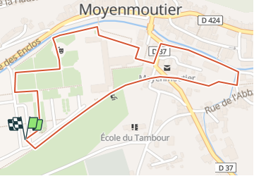
Trail Walking of 1.5 km to be discovered at Grand Est, Vosges, Moyenmoutier. This trail is proposed by salomé.

Description

Venez découvrir le jardin de la magnifique Abbaye de Moyenmoutier.Pour cela garez vous sur le parking de l'Abbaye,dirigez vous sur la voie verte et longez celle ci  jusqu'aux 2 passages pour piétons que vous traversez pour aller en face. Continuez sur la voie verte jusqu'à la prochaine intersection,puis prenez à droite puis à gauche pour rejoindre le quai du Rabodeau. Longez le quai jusqu' à hauteur de l'Abbaye puis traversez pour emprunter le côté droit de l'Abbaye, vous vous trouvez à présent dans le jardin, promenez vous à votre guise avant de rejoindre votre véhicule.

Elevation profile

Points of interest

Point of interest Moyenmoutier - WC public  - Photo
salomé
MOYENMOUTIER 

Positioning

Country:
France
Region :
Grand Est
Department/Province :
Vosges
Municipality :
Moyenmoutier
Location:
Unknown
Start:(UTM)
345213 ; 5360294 (32U) N.

Trails nearby

Trail Horseback riding Étival-Clairefontaine - suuntoapp-HorsebackRiding-2024-04-14T08-00-40Z - Photo
Horseback riding
GUIDE
holtzv

Horseback riding

Medium
(1)
Étival-Clairefontaine, Grand Est, Vosges, France
28 km | 37 km-effort
4h 51min
Yes
Trail Walking Senones - roche de la mère henry - Photo
Walking
remysimon

Walking

Easy
(1)
Senones, Grand Est, Vosges, France
9.6 km | 13.3 km-effort
2h 46min
No
Trail Mountain bike Raon-l'Étape - sortie vtt 03112019 la trouche - Photo
Mountain bike
GUIDE
fabwin

Mountain bike

Medium
Raon-l'Étape, Grand Est, Vosges, France
18.6 km | 26 km-effort
1h 45min
Yes
Trail Mountain bike Moyenmoutier - sortie vtt 14042019 Moyenmoutier - Photo
Mountain bike
GUIDE
fabwin

Mountain bike

Difficult
Moyenmoutier, Grand Est, Vosges, France
30 km | 43 km-effort
3h 0min
No
Trail Mountain bike Moyenmoutier - tête du coquin - Photo
Mountain bike
lasconi88

Mountain bike

Easy
(1)
Moyenmoutier, Grand Est, Vosges, France
34 km | 46 km-effort
3h 33min
Yes
Trail Cycle Étival-Clairefontaine - etival luvigny voie verte - Photo
Cycle
lasconi88

Cycle

Very easy
(1)
Étival-Clairefontaine, Grand Est, Vosges, France
32 km | 37 km-effort
2h 40min
No
Trail Walking Raon-l'Étape - croquettes de - Photo
Walking
msylviotte

Walking

Difficult
(1)
Raon-l'Étape, Grand Est, Vosges, France
9.9 km | 13.5 km-effort
3h 4min
Yes
Trail On foot Moyenmoutier - Circuit de la Haute Pierre - Photo
On foot
GUIDE+

On foot

Easy
Moyenmoutier, Grand Est, Vosges, France
9.3 km | 14.6 km-effort
3h 18min
Yes
Trail Mountain bike Raon-l'Étape - VTT La Trouche- Neufmaisons 03/11/19 - Photo
Mountain bike
vathi54

Mountain bike

Medium
Raon-l'Étape, Grand Est, Vosges, France
19 km | 26 km-effort
2h 39min
Yes


Close
My subscriptions