![](/images/other/stat-length.png)
![Trail Walking Chaponost - Ballade à Chaponost - la vallée en Barret - Photo](https://media.geolcdn.com/t/1900/400/ext.pjpeg?maxdim=2&url=https%3A%2F%2Fstatic1.geolcdn.com%2Fsiteimages%2Fupload%2Ffiles%2F1553511878bg_sport_marche.png)
Ballade à Chaponost - la vallée en Barret
cathel11
User
![Length](/images/other/stat-length.png)
Length
8.7 km
![Max alt](https://static1.geolcdn.com/siteimages/upload/files/1508320355ic_sort_altitude_max_24dp.png)
Max alt
313 m
![Uphill gradient](https://static1.geolcdn.com/siteimages/upload/files/1508320355ic_sort_den_pos_24dp.png)
Uphill gradient
149 m
![Km-Effort](/images/other/stat-length.png)
Km-Effort
10.7 km
![Min alt](https://static1.geolcdn.com/siteimages/upload/files/1508320355ic_sort_altitude_min_24dp.png)
Min alt
215 m
![Downhill gradient](https://static1.geolcdn.com/siteimages/upload/files/1508320355ic_sort_den_neg_24dp.png)
Downhill gradient
151 m
![Boucle](https://static1.geolcdn.com/siteimages/upload/files/16400158638029165_repeat_loop_refresh_sync_direction_icon.png)
Boucle
Yes
Creation date :
2021-09-14 10:53:52.371
Updated on :
2021-09-14 10:55:28.034
![Walking](https://static1.geolcdn.com/sitytour/trail-icons/101.png)
2h25
Difficulty : Medium
![Scan this QR Code to open this trail in the SityTrail application](https://capi.geolives.com/qq0zvz2zws4bq2lad0pu/sitytour/trails/2936189/qr.png?size=200)
FREE GPS app for hiking
About
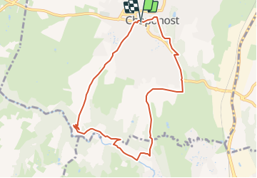
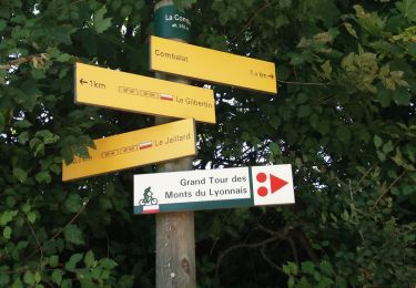
Trail Walking of 8.7 km to be discovered at Auvergne-Rhône-Alpes, Rhône, Chaponost. This trail is proposed by cathel11.
Description
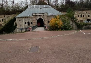
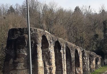
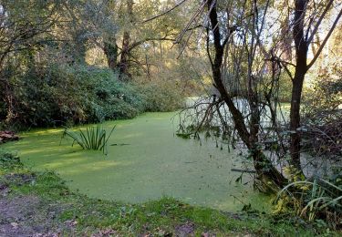
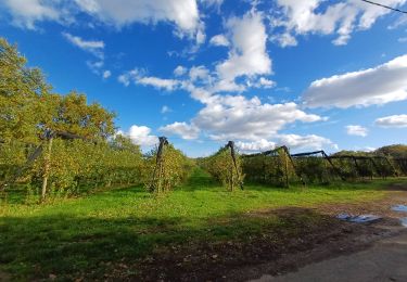
Au coeur de l'espace naturel sensible de la vallée en Barret, vous longez le Garon avant de rejoindre le centre-ville par d'agréables routes de campagne
Positioning
Country:
France
Region :
Auvergne-Rhône-Alpes
Department/Province :
Rhône
Municipality :
Chaponost
Location:
Unknown
Start:(Dec)
Start:(UTM)
635765 ; 5063356 (31T) N.
Comments
Trails nearby
![Trail Walking Craponne - départ cimetière de Craponne - Photo](https://media.geolcdn.com/t/375/260/69d5a206-99fc-4c26-ba2a-07de4fc87322.jpg&format=jpg&maxdim=2)
![Walking Walking](https://static1.geolcdn.com/sitytour/trail-icons/101.png)
départ cimetière de Craponne
Walking
Easy
(1)
Craponne,
Auvergne-Rhône-Alpes,
Métropole de Lyon,
France
![](/images/other/stat-length.png)
10.3 km | 13.1 km-effort
2h 36min
![](https://static1.geolcdn.com/siteimages/upload/files/16400158638029165_repeat_loop_refresh_sync_direction_icon.png)
Yes
![Trail Mountain bike Grézieu-la-Varenne - scott25 - Photo](https://media.geolcdn.com/t/375/260/ext.jpg?maxdim=2&url=https%3A%2F%2Fstatic1.geolcdn.com%2Fsiteimages%2Fupload%2Ffiles%2F1524743154velo.jpg)
![Mountain bike Mountain bike](https://static1.geolcdn.com/sitytour/trail-icons/202.png)
scott25
Mountain bike
Very easy
(1)
Grézieu-la-Varenne,
Auvergne-Rhône-Alpes,
Rhône,
France
![](/images/other/stat-length.png)
26 km | 37 km-effort
Unknown
![](https://static1.geolcdn.com/siteimages/upload/files/16400158638029165_repeat_loop_refresh_sync_direction_icon.png)
Yes
![Trail Walking Chaponost - test siarg - Photo](https://media.geolcdn.com/t/375/260/f80b1933-0169-4fba-aa52-8e253037af80.jpg&format=jpg&maxdim=2)
![Walking Walking](https://static1.geolcdn.com/sitytour/trail-icons/101.png)
test siarg
Walking
Medium
Chaponost,
Auvergne-Rhône-Alpes,
Rhône,
France
![](/images/other/stat-length.png)
8.4 km | 9.8 km-effort
3h 7min
![](https://static1.geolcdn.com/siteimages/upload/files/16400158638029165_repeat_loop_refresh_sync_direction_icon.png)
No
![Trail Walking Grézieu-la-Varenne - grezieu la varenne. boucle - Photo](https://media.geolcdn.com/t/375/260/0bd10c13-fbf7-47f8-ab7f-ba3636449192.jpg&format=jpg&maxdim=2)
![Walking Walking](https://static1.geolcdn.com/sitytour/trail-icons/101.png)
grezieu la varenne. boucle
Walking
Difficult
Grézieu-la-Varenne,
Auvergne-Rhône-Alpes,
Rhône,
France
![](/images/other/stat-length.png)
11.2 km | 13.8 km-effort
2h 24min
![](https://static1.geolcdn.com/siteimages/upload/files/16400158638029165_repeat_loop_refresh_sync_direction_icon.png)
Yes
![Trail Walking Francheville - Aqueduc et fort du Bruissin (PR1) - Photo](https://media.geolcdn.com/t/375/260/3e156afe-0a53-4173-8a16-0a0e11f72681.jpg&format=jpg&maxdim=2)
![Walking Walking](https://static1.geolcdn.com/sitytour/trail-icons/101.png)
Aqueduc et fort du Bruissin (PR1)
Walking
Easy
Francheville,
Auvergne-Rhône-Alpes,
Métropole de Lyon,
France
![](/images/other/stat-length.png)
19.1 km | 23 km-effort
5h 20min
![](https://static1.geolcdn.com/siteimages/upload/files/16400158638029165_repeat_loop_refresh_sync_direction_icon.png)
Yes
![Trail Walking Brignais - de brigais à Orlienas - Photo](https://media.geolcdn.com/t/375/260/de2c1c91-441a-48e8-801a-ab80cd8ff2ae.jpg&format=jpg&maxdim=2)
![Walking Walking](https://static1.geolcdn.com/sitytour/trail-icons/101.png)
de brigais à Orlienas
Walking
Medium
(1)
Brignais,
Auvergne-Rhône-Alpes,
Rhône,
France
![](/images/other/stat-length.png)
9.2 km | 11.6 km-effort
2h 6min
![](https://static1.geolcdn.com/siteimages/upload/files/16400158638029165_repeat_loop_refresh_sync_direction_icon.png)
Yes
![Trail Walking Brindas - de brindas à soucieux en jarrest - Photo](https://media.geolcdn.com/t/375/260/0437dd9e-577f-4074-95ce-afdcae6f044f.jpg&format=jpg&maxdim=2)
![Walking Walking](https://static1.geolcdn.com/sitytour/trail-icons/101.png)
de brindas à soucieux en jarrest
Walking
Very difficult
Brindas,
Auvergne-Rhône-Alpes,
Rhône,
France
![](/images/other/stat-length.png)
18 km | 21 km-effort
3h 52min
![](https://static1.geolcdn.com/siteimages/upload/files/16400158638029165_repeat_loop_refresh_sync_direction_icon.png)
Yes
![Trail Walking Craponne - de Craponne à Brindas . - Photo](https://media.geolcdn.com/t/375/260/c4387d92-62eb-4940-8168-b397ca0a6564.jpg&format=jpg&maxdim=2)
![Walking Walking](https://static1.geolcdn.com/sitytour/trail-icons/101.png)
de Craponne à Brindas .
Walking
Medium
Craponne,
Auvergne-Rhône-Alpes,
Métropole de Lyon,
France
![](/images/other/stat-length.png)
9.5 km | 11.5 km-effort
2h 8min
![](https://static1.geolcdn.com/siteimages/upload/files/16400158638029165_repeat_loop_refresh_sync_direction_icon.png)
Yes
![Trail Walking Chaponost - de Chaponost à Brignais AR - Photo](https://media.geolcdn.com/t/375/260/748757ec-45c0-4bb1-82f9-93d25db52f90.jpg&format=jpg&maxdim=2)
![Walking Walking](https://static1.geolcdn.com/sitytour/trail-icons/101.png)
de Chaponost à Brignais AR
Walking
Difficult
Chaponost,
Auvergne-Rhône-Alpes,
Rhône,
France
![](/images/other/stat-length.png)
11.8 km | 14.3 km-effort
2h 40min
![](https://static1.geolcdn.com/siteimages/upload/files/16400158638029165_repeat_loop_refresh_sync_direction_icon.png)
Yes