![](/images/other/stat-length.png)
![Trail Moto cross Réalmont - Rando Monts de Lacaune, Laouzas, montagne noire. - Photo](https://media.geolcdn.com/t/1900/400/11fc1da8-59d3-4b05-9dbc-670b2f23e8e6.jpg&format=pjpeg&maxdim=2)
Rando Monts de Lacaune, Laouzas, montagne noire.
jpipacific
User
![Length](/images/other/stat-length.png)
Length
178 km
![Max alt](https://static1.geolcdn.com/siteimages/upload/files/1508320355ic_sort_altitude_max_24dp.png)
Max alt
1209 m
![Uphill gradient](https://static1.geolcdn.com/siteimages/upload/files/1508320355ic_sort_den_pos_24dp.png)
Uphill gradient
4055 m
![Km-Effort](/images/other/stat-length.png)
Km-Effort
232 km
![Min alt](https://static1.geolcdn.com/siteimages/upload/files/1508320355ic_sort_altitude_min_24dp.png)
Min alt
193 m
![Downhill gradient](https://static1.geolcdn.com/siteimages/upload/files/1508320355ic_sort_den_neg_24dp.png)
Downhill gradient
4055 m
![Boucle](https://static1.geolcdn.com/siteimages/upload/files/16400158638029165_repeat_loop_refresh_sync_direction_icon.png)
Boucle
Yes
Creation date :
2021-09-13 08:33:06.743
Updated on :
2021-09-14 07:29:30.883
![Moto cross](https://static1.geolcdn.com/sitytour/trail-icons/406.png)
4h43
Difficulty : Difficult
![Scan this QR Code to open this trail in the SityTrail application](https://capi.geolives.com/qq0zvz2zws4bq2lad0pu/sitytour/trails/2935501/qr.png?size=200)
FREE GPS app for hiking
About
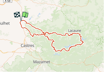
Trail Moto cross of 178 km to be discovered at Occitania, Tarn, Réalmont. This trail is proposed by jpipacific.
Description
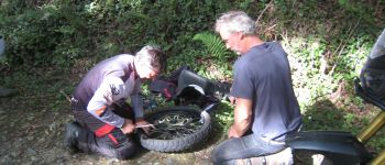
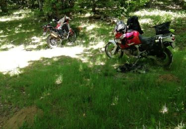
Randonnée faite avec 2 Honda Africa Twin CRF 1000 , une Honda Africa Twin 750 et une Yamaha 700 Ténéré.
Très belle randonnée avec des passages très diversifiés.
Un connaissance de la moto tout terrain s'impose.
Positioning
Country:
France
Region :
Occitania
Department/Province :
Tarn
Municipality :
Réalmont
Location:
Unknown
Start:(Dec)
Start:(UTM)
434211 ; 4846744 (31T) N.
Comments
Trails nearby
![Trail Walking Terre-de-Bancalié - 81_Saint Lieux Lafenasse - Photo](https://media.geolcdn.com/t/375/260/ext.jpg?maxdim=2&url=https%3A%2F%2Fstatic1.geolcdn.com%2Fsiteimages%2Fupload%2Ffiles%2F1553511878bg_sport_marche.png)
![Walking Walking](https://static1.geolcdn.com/sitytour/trail-icons/101.png)
81_Saint Lieux Lafenasse
Walking
Medium
(1)
Terre-de-Bancalié,
Occitania,
Tarn,
France
![](/images/other/stat-length.png)
18.1 km | 23 km-effort
4h 27min
![](https://static1.geolcdn.com/siteimages/upload/files/16400158638029165_repeat_loop_refresh_sync_direction_icon.png)
Yes
![Trail Moto cross Réalmont - Roquecourbe, Pic de nore, Minerve - Photo](https://media.geolcdn.com/t/375/260/e70284d5-3329-4fb7-a41a-d11af4aac54b.jpg&format=jpg&maxdim=2)
![Moto cross Moto cross](https://static1.geolcdn.com/sitytour/trail-icons/406.png)
Roquecourbe, Pic de nore, Minerve
Moto cross
Difficult
Réalmont,
Occitania,
Tarn,
France
![](/images/other/stat-length.png)
166 km | 225 km-effort
6h 9min
![](https://static1.geolcdn.com/siteimages/upload/files/16400158638029165_repeat_loop_refresh_sync_direction_icon.png)
No
![Trail Moto cross Réalmont - Randonnée de reconnaissance Vabre St Pons - Photo](https://media.geolcdn.com/t/375/260/83189e89-3200-4ac5-ab66-38f75ce84633.jpg&format=jpg&maxdim=2)
![Moto cross Moto cross](https://static1.geolcdn.com/sitytour/trail-icons/406.png)
Randonnée de reconnaissance Vabre St Pons
Moto cross
Difficult
Réalmont,
Occitania,
Tarn,
France
![](/images/other/stat-length.png)
152 km | 202 km-effort
5h 33min
![](https://static1.geolcdn.com/siteimages/upload/files/16400158638029165_repeat_loop_refresh_sync_direction_icon.png)
No
![Trail Walking Lombers - Lombers - Photo](https://media.geolcdn.com/t/375/260/b0a7a518-d2a1-49cb-8c54-d41b2957fa13.jpg&format=jpg&maxdim=2)
![Walking Walking](https://static1.geolcdn.com/sitytour/trail-icons/101.png)
![Trail Moto cross Réalmont - Balade de juillet montagne noire - Photo](https://media.geolcdn.com/t/375/260/4e6c59cc-6840-4f1a-aa0a-11fa3c2db325.jpg&format=jpg&maxdim=2)
![Moto cross Moto cross](https://static1.geolcdn.com/sitytour/trail-icons/406.png)
Balade de juillet montagne noire
Moto cross
Easy
Réalmont,
Occitania,
Tarn,
France
![](/images/other/stat-length.png)
235 km | 307 km-effort
6h 0min
![](https://static1.geolcdn.com/siteimages/upload/files/16400158638029165_repeat_loop_refresh_sync_direction_icon.png)
Yes
![Trail Moto cross Réalmont - Ballade dans le parc du haut languedoc - Photo](https://media.geolcdn.com/t/375/260/68fa449d-4b95-401c-b792-98cdcd4b6c01.jpg&format=jpg&maxdim=2)
![Moto cross Moto cross](https://static1.geolcdn.com/sitytour/trail-icons/406.png)
Ballade dans le parc du haut languedoc
Moto cross
Medium
Réalmont,
Occitania,
Tarn,
France
![](/images/other/stat-length.png)
275 km | 358 km-effort
7h 43min
![](https://static1.geolcdn.com/siteimages/upload/files/16400158638029165_repeat_loop_refresh_sync_direction_icon.png)
No
![Trail Walking Terre-de-Bancalié - 2023-01-25_07h53m46_Cirkwi-Chemin_Des_Mineurs - Photo](https://media.geolcdn.com/t/375/260/ext.jpg?maxdim=2&url=https%3A%2F%2Fstatic1.geolcdn.com%2Fsiteimages%2Fupload%2Ffiles%2F1553511878bg_sport_marche.png)
![Walking Walking](https://static1.geolcdn.com/sitytour/trail-icons/101.png)
2023-01-25_07h53m46_Cirkwi-Chemin_Des_Mineurs
Walking
Difficult
Terre-de-Bancalié,
Occitania,
Tarn,
France
![](/images/other/stat-length.png)
10.4 km | 14 km-effort
3h 11min
![](https://static1.geolcdn.com/siteimages/upload/files/16400158638029165_repeat_loop_refresh_sync_direction_icon.png)
Yes
![Trail Walking Lombers - Lombers formation - Photo](https://media.geolcdn.com/t/375/260/ext.jpg?maxdim=2&url=https%3A%2F%2Fstatic1.geolcdn.com%2Fsiteimages%2Fupload%2Ffiles%2F1553511878bg_sport_marche.png)
![Walking Walking](https://static1.geolcdn.com/sitytour/trail-icons/101.png)
Lombers formation
Walking
Very easy
Lombers,
Occitania,
Tarn,
France
![](/images/other/stat-length.png)
6.4 km | 8.5 km-effort
1h 59min
![](https://static1.geolcdn.com/siteimages/upload/files/16400158638029165_repeat_loop_refresh_sync_direction_icon.png)
Yes
![Trail Motorbike Réalmont - rando 2 - Photo](https://media.geolcdn.com/t/375/260/ext.jpg?maxdim=2&url=https%3A%2F%2Fstatic1.geolcdn.com%2Fsiteimages%2Fupload%2Ffiles%2F1524743155moto.jpg)
![Motorbike Motorbike](https://static1.geolcdn.com/sitytour/trail-icons/402.png)