![](/images/other/stat-length.png)
20210913 - Cornesse 6.5 Km
pierreh01
User GUIDE
![Length](/images/other/stat-length.png)
Length
6.2 km
![Max alt](https://static1.geolcdn.com/siteimages/upload/files/1508320355ic_sort_altitude_max_24dp.png)
Max alt
272 m
![Uphill gradient](https://static1.geolcdn.com/siteimages/upload/files/1508320355ic_sort_den_pos_24dp.png)
Uphill gradient
205 m
![Km-Effort](/images/other/stat-length.png)
Km-Effort
8.9 km
![Min alt](https://static1.geolcdn.com/siteimages/upload/files/1508320355ic_sort_altitude_min_24dp.png)
Min alt
132 m
![Downhill gradient](https://static1.geolcdn.com/siteimages/upload/files/1508320355ic_sort_den_neg_24dp.png)
Downhill gradient
204 m
![Boucle](https://static1.geolcdn.com/siteimages/upload/files/16400158638029165_repeat_loop_refresh_sync_direction_icon.png)
Boucle
Yes
Creation date :
2021-09-13 11:56:48.0
Updated on :
2021-09-13 15:45:34.028
![Walking](https://static1.geolcdn.com/sitytour/trail-icons/101.png)
2h13
Difficulty : Medium
![Scan this QR Code to open this trail in the SityTrail application](https://capi.geolives.com/qq0zvz2zws4bq2lad0pu/sitytour/trails/2935292/qr.png?size=200)
FREE GPS app for hiking
About
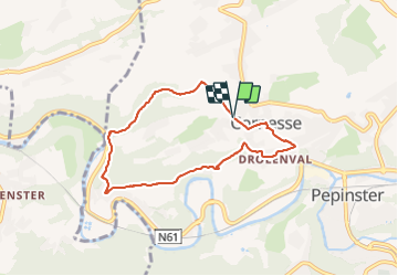
Trail Walking of 6.2 km to be discovered at Wallonia, Liège, Pepinster. This trail is proposed by pierreh01.
Description
Lundi 13 septeembre 2021
Balade en boucle, non balisée, au départ du cimetière de Cornesse.
Balade assez technique avec des dénivelés importants à aborder à son rythme et en regardant où on met ses pieds (cailloux, racines).
Beaux points de vue.
Positioning
Country:
Belgium
Region :
Wallonia
Department/Province :
Liège
Municipality :
Pepinster
Location:
Unknown
Start:(Dec)
Start:(UTM)
697262 ; 5606285 (31U) N.
Comments
Trails nearby
![Trail Walking Theux - Theux - Natura 2000, des sites qui valent le détour - LG22 - Photo](https://media.geolcdn.com/t/375/260/ext.jpg?maxdim=2&url=https%3A%2F%2Fservices.sitytrail.com%2FGeolivesWS%2FDownloadMedia.ashx%3FTrailID%3D612638%26Media%3D53072597-f13a-4b1e-b213-a2c1df094f1f.JPG)
![Walking Walking](https://static1.geolcdn.com/sitytour/trail-icons/101.png)
Theux - Natura 2000, des sites qui valent le détour - LG22
Walking
Medium
(6)
Theux,
Wallonia,
Liège,
Belgium
![](/images/other/stat-length.png)
12.7 km | 16.8 km-effort
3h 31min
![](https://static1.geolcdn.com/siteimages/upload/files/16400158638029165_repeat_loop_refresh_sync_direction_icon.png)
Yes
![Trail Walking Pepinster - RB-Lg-23_Soiron_via-racc-2 - Photo](https://media.geolcdn.com/t/375/260/ext.jpg?maxdim=2&url=https%3A%2F%2Fservices.sitytrail.com%2FGeolivesWS%2FDownloadMedia.ashx%3FTrailID%3D400856%26Media%3D1646b7fd-8650-448d-bc3d-5efa9ed8c932.jpg)
![Walking Walking](https://static1.geolcdn.com/sitytour/trail-icons/101.png)
RB-Lg-23_Soiron_via-racc-2
Walking
(8)
Pepinster,
Wallonia,
Liège,
Belgium
![](/images/other/stat-length.png)
13.4 km | 17.5 km-effort
3h 58min
![](https://static1.geolcdn.com/siteimages/upload/files/16400158638029165_repeat_loop_refresh_sync_direction_icon.png)
Yes
![Trail Walking Pepinster - RB-Lg-23_Soiron - Photo](https://media.geolcdn.com/t/375/260/ext.jpg?maxdim=2&url=https%3A%2F%2Fservices.sitytrail.com%2FGeolivesWS%2FDownloadMedia.ashx%3FTrailID%3D400853%26Media%3D1646b7fd-8650-448d-bc3d-5efa9ed8c932.jpg)
![Walking Walking](https://static1.geolcdn.com/sitytour/trail-icons/101.png)
![Trail Walking Trooz - RB-Lg-03 - Entre Vesdre et Hoëgne - Photo](https://media.geolcdn.com/t/375/260/ext.jpg?maxdim=2&url=https%3A%2F%2Fservices.sitytrail.com%2FGeolivesWS%2FDownloadMedia.ashx%3FTrailID%3D179559%26Media%3Dcef2de81-7d4f-4fcd-9e9d-f315370fe61f.jpg)
![Walking Walking](https://static1.geolcdn.com/sitytour/trail-icons/101.png)
RB-Lg-03 - Entre Vesdre et Hoëgne
Walking
Medium
(12)
Trooz,
Wallonia,
Liège,
Belgium
![](/images/other/stat-length.png)
22 km | 29 km-effort
6h 9min
![](https://static1.geolcdn.com/siteimages/upload/files/16400158638029165_repeat_loop_refresh_sync_direction_icon.png)
Yes
![Trail Walking Sprimont - Banneux - Rouge Thier - Adzeux - Photo](https://media.geolcdn.com/t/375/260/0f185ab2-d29a-4b49-b676-7a8415068951.jpg&format=jpg&maxdim=2)
![Walking Walking](https://static1.geolcdn.com/sitytour/trail-icons/101.png)
Banneux - Rouge Thier - Adzeux
Walking
Easy
(4)
Sprimont,
Wallonia,
Liège,
Belgium
![](/images/other/stat-length.png)
9.1 km | 11.3 km-effort
2h 34min
![](https://static1.geolcdn.com/siteimages/upload/files/16400158638029165_repeat_loop_refresh_sync_direction_icon.png)
Yes
![Trail Walking Pepinster - 2022-05-13_11h44m22_Cirkwi-Soiron_6___Tribomont,_Wegnez - Photo](https://media.geolcdn.com/t/375/260/ec8c930a-9871-4566-956d-2a2016034199.jpg&format=jpg&maxdim=2)
![Walking Walking](https://static1.geolcdn.com/sitytour/trail-icons/101.png)
2022-05-13_11h44m22_Cirkwi-Soiron_6___Tribomont,_Wegnez
Walking
Easy
(1)
Pepinster,
Wallonia,
Liège,
Belgium
![](/images/other/stat-length.png)
9.5 km | 12.5 km-effort
2h 50min
![](https://static1.geolcdn.com/siteimages/upload/files/16400158638029165_repeat_loop_refresh_sync_direction_icon.png)
Yes
![Walking Walking](https://static1.geolcdn.com/sitytour/trail-icons/101.png)
20220307 - Saint-Hadelin 8.8 Km
Walking
Medium
(1)
Olne,
Wallonia,
Liège,
Belgium
![](/images/other/stat-length.png)
8.4 km | 10.9 km-effort
2h 24min
![](https://static1.geolcdn.com/siteimages/upload/files/16400158638029165_repeat_loop_refresh_sync_direction_icon.png)
Yes
![Trail Walking Trooz - 2022-02-03_17h57m35_BaladedeFraipont - Photo](https://media.geolcdn.com/t/375/260/a22be754-a7d6-4ac7-b88b-6e30a6735908.jpg&format=jpg&maxdim=2)
![Walking Walking](https://static1.geolcdn.com/sitytour/trail-icons/101.png)
2022-02-03_17h57m35_BaladedeFraipont
Walking
Medium
(1)
Trooz,
Wallonia,
Liège,
Belgium
![](/images/other/stat-length.png)
12.3 km | 17.3 km-effort
3h 55min
![](https://static1.geolcdn.com/siteimages/upload/files/16400158638029165_repeat_loop_refresh_sync_direction_icon.png)
Yes
![Trail Walking Olne - 2021-03-10_16h10m11_1409 - Photo](https://media.geolcdn.com/t/375/260/8c16a020-3972-4fd4-95a4-e68b814bf4ee.jpg&format=jpg&maxdim=2)
![Walking Walking](https://static1.geolcdn.com/sitytour/trail-icons/101.png)
2021-03-10_16h10m11_1409
Walking
Medium
(3)
Olne,
Wallonia,
Liège,
Belgium
![](/images/other/stat-length.png)
11.7 km | 16.1 km-effort
3h 39min
![](https://static1.geolcdn.com/siteimages/upload/files/16400158638029165_repeat_loop_refresh_sync_direction_icon.png)
Yes