Trail Walking Thann - Le chemin de Compostelle en Franche-Comté - Photo

Le chemin de Compostelle en Franche-Comté

 erual71
erual71

User

© OpenStreetMap contributors
Length
Length
1181 km
Boucle
Boucle
No
Creation date :
2021-09-10 12:42:28.04
Updated on :
2021-09-10 12:44:13.308

(0 Reviews)

Walking
Walking
--
Difficulty : Very easy

Scan this QR Code to open this trail in the SityTrail application

FREE GPS app for hiking

Logo SityTrail SityTrail

IGN / Geographical institutes

Download SityTrail from the App Store Download SityTrail from Google Play

Logo SityTrail SityTrail World

The world is yours!

Download SityTrail from the App Store Download SityTrail from Google Play Download SityTrail on Huawei AppGallery

About

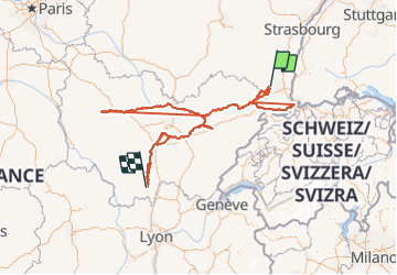
Trail Walking of 1181 km to be discovered at Grand Est, Haut-Rhin, Thann. This trail is proposed by erual71.

Description

Le chemin de Compostelle en Franche-Comté constitue le chaînon manquant reliant le chemin d'Alsace à celui de Cluny menant au Puy-en-Velay. De Angeot (Territoire de Belfort) à Saint-Jean-de-Losne (Côte-d'Or) il est fléché avec la coquille européenne jaune sur fond bleu.

Elevation profile

Positioning

Country:
France
Region :
Grand Est
Department/Province :
Haut-Rhin
Municipality :
Thann
Location:
Unknown
Start:(UTM)
358103 ; 5297112 (32T) N.

Trails nearby

Trail Other activity Steinbach - lac du ballon - Photo
Other activity
rodabruna

Other activity

Very easy
(1)
Steinbach, Grand Est, Haut-Rhin, France
33 km | 64 km-effort
5h 1min
No
Trail Walking Bourbach-le-Haut - 2024-01-12_14h17m14_239006910 - Photo
Walking
GUIDE
mumu.larandonneuse

Walking

Difficult
Bourbach-le-Haut, Grand Est, Haut-Rhin, France
11.4 km | 18.5 km-effort
4h 12min
Yes
Trail Walking Thann - SityTrail - 2489713 - thann-roche--albert--grumbachkopf - Photo
Walking
argonneuweg

Walking

Medium
(1)
Thann, Grand Est, Haut-Rhin, France
7.6 km | 12 km-effort
2h 28min
Yes
Trail On foot Bitschwiller-lès-Thann - Bitschwiller les Thann - Rehbrunnel - Abri du Becherkopf - Roche Albert - Photo
On foot
patrickbeyrath

On foot

Medium
(1)
Bitschwiller-lès-Thann, Grand Est, Haut-Rhin, France
10.3 km | 16.4 km-effort
Unknown
Yes
Trail Walking Bitschwiller-lès-Thann - 68 Col du Hundsrück  - FA Gsang - retour ThannerHubel - Photo
Walking

Walking

Medium
(1)
Bitschwiller-lès-Thann, Grand Est, Haut-Rhin, France
11.2 km | 18.4 km-effort
3h 48min
Yes
Trail Walking Thann - Entre Thann et le Molkenrain - Photo
Walking
oscar1

Walking

Difficult
Thann, Grand Est, Haut-Rhin, France
24 km | 39 km-effort
8h 47min
Yes
Trail Electric bike Thann - Thann lac de Kruth  - Photo
Electric bike
apa

Electric bike

Medium
Thann, Grand Est, Haut-Rhin, France
49 km | 58 km-effort
4h 2min
Yes
Trail Walking Steinbach - Rando CLAS du 02/11/2023 - Photo
Walking
boubou68

Walking

Very difficult
Steinbach, Grand Est, Haut-Rhin, France
17.7 km | 27 km-effort
4h 35min
Yes
Trail Walking Steinbach - Rando Marcheurs du 03/07/2023 par ALAIN - Photo
Walking
boubou68

Walking

Very difficult
Steinbach, Grand Est, Haut-Rhin, France
20 km | 34 km-effort
5h 1min
Yes


Close
My subscriptions