![](/images/other/stat-length.png)
![Trail Walking Mirabel-et-Blacons - Chapelle Saint-Christophe - Charsac - Photo](https://media.geolcdn.com/t/1900/400/ae3273a6-ec1d-4a9d-8789-176c8e22d28a.jpg&format=pjpeg&maxdim=2)
Chapelle Saint-Christophe - Charsac
Philindy26
User
![Length](/images/other/stat-length.png)
![Max alt](https://static1.geolcdn.com/siteimages/upload/files/1508320355ic_sort_altitude_max_24dp.png)
![Uphill gradient](https://static1.geolcdn.com/siteimages/upload/files/1508320355ic_sort_den_pos_24dp.png)
![Km-Effort](/images/other/stat-length.png)
![Min alt](https://static1.geolcdn.com/siteimages/upload/files/1508320355ic_sort_altitude_min_24dp.png)
![Downhill gradient](https://static1.geolcdn.com/siteimages/upload/files/1508320355ic_sort_den_neg_24dp.png)
![Boucle](https://static1.geolcdn.com/siteimages/upload/files/16400158638029165_repeat_loop_refresh_sync_direction_icon.png)
![Walking](https://static1.geolcdn.com/sitytour/trail-icons/101.png)
4h50
Difficulty : Difficult
![Scan this QR Code to open this trail in the SityTrail application](https://capi.geolives.com/qq0zvz2zws4bq2lad0pu/sitytour/trails/2929121/qr.png?size=200)
FREE GPS app for hiking
About
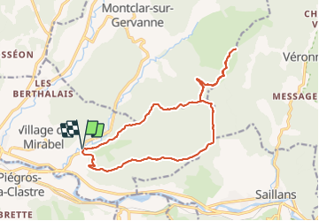
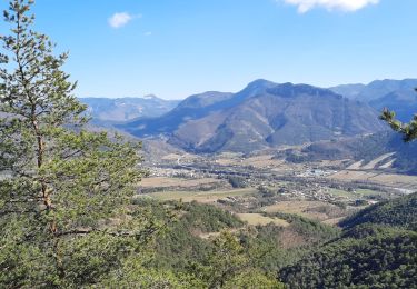
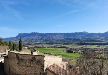
Trail Walking of 17.8 km to be discovered at Auvergne-Rhône-Alpes, Drôme, Mirabel-et-Blacons. This trail is proposed by Philindy26.
Description
Départ chemin de Sauzet, au bord de la D617, commune de Mirabel-et-Blacons (250 m)...
Géolocalisation (Google Maps) : https://goo.gl/maps/1hEeWjYsJKKdy9md6 .
Suivre la D617 au Sud, puis prendre le chemin de Sans Souci, passez le hameau puis suivre à droite un sentier qui vous emmènera sur les crêtes (suivre marque jaune).
Au Serre Peyplat (500 m) direction le col de Sauzet et le col de Pourcheton (610 m). Puis rejoindre le Serre des Trois Bornes (660 m). Là rejoindre la Chapelle Saint-Christophe (559 m) par le col de la Tuilerie (576 m).
Retour par le même chemin jusqu'au Serre des Trois Bornes.
Là prendre la direction du Pêcher...
Suivre le sentier toujours tout droit (marque jaune) jusqu'au Chemin de Sauzet.
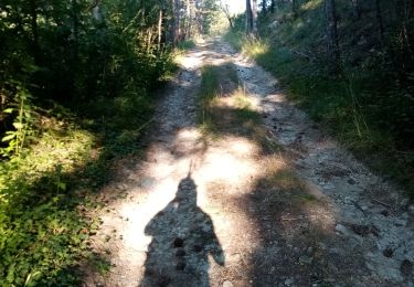
Positioning
Comments
Trails nearby
![Walking Walking](https://static1.geolcdn.com/sitytour/trail-icons/101.png)
Walking
![](/images/other/stat-length.png)
![](https://static1.geolcdn.com/siteimages/upload/files/16400158638029165_repeat_loop_refresh_sync_direction_icon.png)
![Trail Walking Piégros-la-Clastre - Pas de Lauzen Col de la Chaudière - Photo](https://media.geolcdn.com/t/375/260/ext.jpg?maxdim=2&url=https%3A%2F%2Fservices.sitytrail.com%2FGeolivesWS%2FDownloadMedia.ashx%3FTrailID%3D141403%26Media%3D20120724110938.jpeg)
![Walking Walking](https://static1.geolcdn.com/sitytour/trail-icons/101.png)
Walking
![](/images/other/stat-length.png)
![](https://static1.geolcdn.com/siteimages/upload/files/16400158638029165_repeat_loop_refresh_sync_direction_icon.png)
![Trail Walking Montclar-sur-Gervanne - Montclar sur Gervanne-Col Gerbe-Chple St Christophe 17km - Photo](https://media.geolcdn.com/t/375/260/1c8b8899-04e8-4a27-b14a-14d516682923.jpg&format=jpg&maxdim=2)
![Walking Walking](https://static1.geolcdn.com/sitytour/trail-icons/101.png)
Walking
![](/images/other/stat-length.png)
![](https://static1.geolcdn.com/siteimages/upload/files/16400158638029165_repeat_loop_refresh_sync_direction_icon.png)
![Trail Walking Montclar-sur-Gervanne - 2023-02-26_18h25m27_Montclar sur Gervanne 16km - Photo](https://media.geolcdn.com/t/375/260/ebf5c7b8-3682-4aaf-a165-5eb68ffb7b11.jpg&format=jpg&maxdim=2)
![Walking Walking](https://static1.geolcdn.com/sitytour/trail-icons/101.png)
Walking
![](/images/other/stat-length.png)
![](https://static1.geolcdn.com/siteimages/upload/files/16400158638029165_repeat_loop_refresh_sync_direction_icon.png)
![Trail Walking Piégros-la-Clastre - cht de Piegros, chap de Médard - Photo](https://media.geolcdn.com/t/375/260/9cd8a646-1714-40d6-bd7d-290d8ba4a2e6.jpg&format=jpg&maxdim=2)
![Walking Walking](https://static1.geolcdn.com/sitytour/trail-icons/101.png)
Walking
![](/images/other/stat-length.png)
![](https://static1.geolcdn.com/siteimages/upload/files/16400158638029165_repeat_loop_refresh_sync_direction_icon.png)
![Trail Walking Mirabel-et-Blacons - Mirabel et Balcons de la Drôme 16 km - Photo](https://media.geolcdn.com/t/375/260/963acc32-6a93-45d3-af60-bd090da1d225.jpg&format=jpg&maxdim=2)
![Walking Walking](https://static1.geolcdn.com/sitytour/trail-icons/101.png)
Walking
![](/images/other/stat-length.png)
![](https://static1.geolcdn.com/siteimages/upload/files/16400158638029165_repeat_loop_refresh_sync_direction_icon.png)
![Trail Walking Mirabel-et-Blacons - Mirabel et Balcons de La Drôme 18km - Photo](https://media.geolcdn.com/t/375/260/7ccb2739-851d-4c67-a22e-9a9b8b7642c6.jpg&format=jpg&maxdim=2)
![Walking Walking](https://static1.geolcdn.com/sitytour/trail-icons/101.png)
Walking
![](/images/other/stat-length.png)
![](https://static1.geolcdn.com/siteimages/upload/files/16400158638029165_repeat_loop_refresh_sync_direction_icon.png)
![Trail Walking Mirabel-et-Blacons - Col de Pourcheton - Photo](https://media.geolcdn.com/t/375/260/29397ae2-1f83-4231-8d6d-5acd5ad8814a.jpg&format=jpg&maxdim=2)
![Walking Walking](https://static1.geolcdn.com/sitytour/trail-icons/101.png)
Walking
![](/images/other/stat-length.png)
![](https://static1.geolcdn.com/siteimages/upload/files/16400158638029165_repeat_loop_refresh_sync_direction_icon.png)
![Trail Walking Mirabel-et-Blacons - Le vieux Mirabel - Photo](https://media.geolcdn.com/t/375/260/6283c72e-165b-49ca-8460-8f24dc97a5b9.jpg&format=jpg&maxdim=2)
![Walking Walking](https://static1.geolcdn.com/sitytour/trail-icons/101.png)
Walking
![](/images/other/stat-length.png)
![](https://static1.geolcdn.com/siteimages/upload/files/16400158638029165_repeat_loop_refresh_sync_direction_icon.png)