![](/images/other/stat-length.png)
![Trail Walking Plougoumelen - Randonnée le Traon - Photo](https://media.geolcdn.com/t/1900/400/f18e384f-74f4-4a6c-abee-ebddef7c86e2.jpg&format=pjpeg&maxdim=2)
Randonnée le Traon
jpbonnemains
User
![Length](/images/other/stat-length.png)
Length
19.2 km
![Max alt](https://static1.geolcdn.com/siteimages/upload/files/1508320355ic_sort_altitude_max_24dp.png)
Max alt
40 m
![Uphill gradient](https://static1.geolcdn.com/siteimages/upload/files/1508320355ic_sort_den_pos_24dp.png)
Uphill gradient
215 m
![Km-Effort](/images/other/stat-length.png)
Km-Effort
22 km
![Min alt](https://static1.geolcdn.com/siteimages/upload/files/1508320355ic_sort_altitude_min_24dp.png)
Min alt
-1 m
![Downhill gradient](https://static1.geolcdn.com/siteimages/upload/files/1508320355ic_sort_den_neg_24dp.png)
Downhill gradient
213 m
![Boucle](https://static1.geolcdn.com/siteimages/upload/files/16400158638029165_repeat_loop_refresh_sync_direction_icon.png)
Boucle
Yes
Creation date :
2021-09-05 08:04:16.0
Updated on :
2021-09-05 15:46:58.228
![Walking](https://static1.geolcdn.com/sitytour/trail-icons/101.png)
5h09
Difficulty : Unknown
![Scan this QR Code to open this trail in the SityTrail application](https://capi.geolives.com/qq0zvz2zws4bq2lad0pu/sitytour/trails/2926005/qr.png?size=200)
FREE GPS app for hiking
About
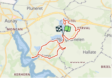
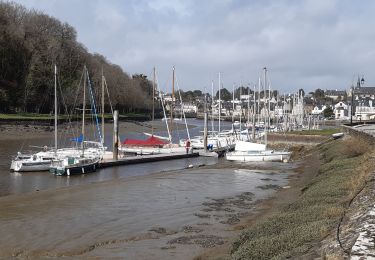
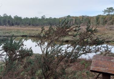
Trail Walking of 19.2 km to be discovered at Brittany, Morbihan, Plougoumelen. This trail is proposed by jpbonnemains.
Description
Magnifique et variées alternant forêt gouttière sentier côtier aber breton
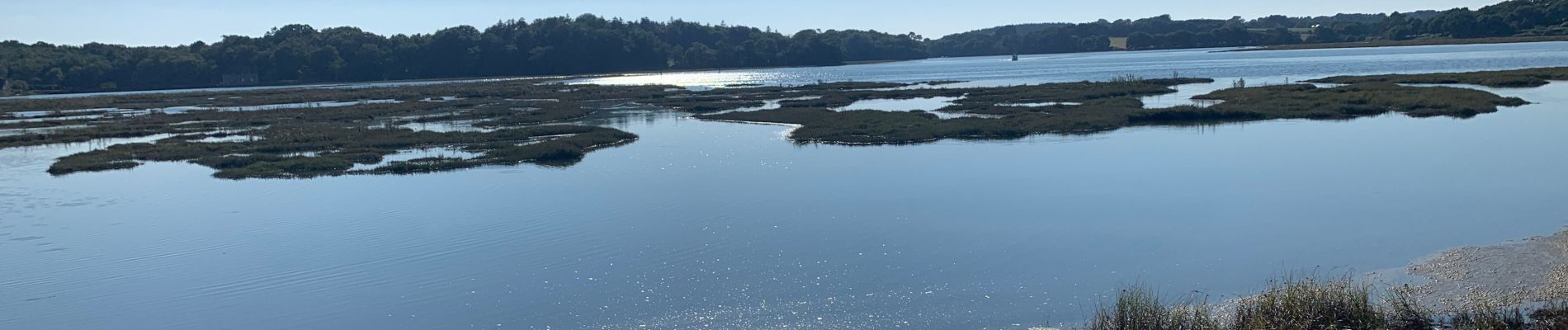
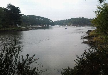
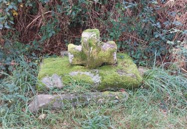
Positioning
Country:
France
Region :
Brittany
Department/Province :
Morbihan
Municipality :
Plougoumelen
Location:
Unknown
Start:(Dec)
Start:(UTM)
505602 ; 5277986 (30T) N.
Comments
Trails nearby
![Trail Walking Le Bono - Du Bono à la Chapelle de Saint-Avoye - Photo](https://media.geolcdn.com/t/375/260/ext.jpg?maxdim=2&url=https%3A%2F%2Fservices.sitytrail.com%2FGeolivesWS%2FDownloadMedia.ashx%3FTrailID%3D455675%26Media%3Dfix__20150807180035.jpg)
![Walking Walking](https://static1.geolcdn.com/sitytour/trail-icons/101.png)
Du Bono à la Chapelle de Saint-Avoye
Walking
Easy
(1)
Le Bono,
Brittany,
Morbihan,
France
![](/images/other/stat-length.png)
8 km | 9.3 km-effort
2h 47min
![](https://static1.geolcdn.com/siteimages/upload/files/16400158638029165_repeat_loop_refresh_sync_direction_icon.png)
Yes
![Trail Walking Pluneret - st Avoye - Photo](https://media.geolcdn.com/t/375/260/ext.jpg?maxdim=2&url=https%3A%2F%2Fservices.sitytrail.com%2FGeolivesWS%2FDownloadMedia.ashx%3FTrailID%3D159588%26Media%3D20121024110349.jpeg)
![Walking Walking](https://static1.geolcdn.com/sitytour/trail-icons/101.png)
![Trail Walking Ploeren - Ploeren - Photo](https://media.geolcdn.com/t/375/260/ext.jpg?maxdim=2&url=https%3A%2F%2Fstatic1.geolcdn.com%2Fsiteimages%2Fupload%2Ffiles%2F1553511878bg_sport_marche.png)
![Walking Walking](https://static1.geolcdn.com/sitytour/trail-icons/101.png)
Ploeren
Walking
Very easy
(1)
Ploeren,
Brittany,
Morbihan,
France
![](/images/other/stat-length.png)
5.4 km | 6.1 km-effort
1h 27min
![](https://static1.geolcdn.com/siteimages/upload/files/16400158638029165_repeat_loop_refresh_sync_direction_icon.png)
Yes
![Trail Walking Pluneret - PR_56_Pluneret_EA_06_Circuit1b_Tro-Ar-Vourch_20240227 - Photo](https://media.geolcdn.com/t/375/260/5d6bdb50-6a7c-4d72-8e80-1296b3e69841.jpg&format=jpg&maxdim=2)
![Walking Walking](https://static1.geolcdn.com/sitytour/trail-icons/101.png)
PR_56_Pluneret_EA_06_Circuit1b_Tro-Ar-Vourch_20240227
Walking
Very easy
Pluneret,
Brittany,
Morbihan,
France
![](/images/other/stat-length.png)
7.3 km | 8.2 km-effort
1h 51min
![](https://static1.geolcdn.com/siteimages/upload/files/16400158638029165_repeat_loop_refresh_sync_direction_icon.png)
Yes
![Trail Walking Plougoumelen - PR_56_Plougoumelen_CA_03_Circuit4a_Du-Boterff_20231011 - Photo](https://media.geolcdn.com/t/375/260/d3c418c5-7ec8-4dd5-81ed-a4f492fa39d3.jpg&format=jpg&maxdim=2)
![Walking Walking](https://static1.geolcdn.com/sitytour/trail-icons/101.png)
PR_56_Plougoumelen_CA_03_Circuit4a_Du-Boterff_20231011
Walking
Easy
Plougoumelen,
Brittany,
Morbihan,
France
![](/images/other/stat-length.png)
10 km | 11.8 km-effort
2h 40min
![](https://static1.geolcdn.com/siteimages/upload/files/16400158638029165_repeat_loop_refresh_sync_direction_icon.png)
Yes
![Trail Walking Pluneret - PR_56_Pluneret_DA_05_Circuit3b_La-Vallee-Du-Leran_20230917 - Photo](https://media.geolcdn.com/t/375/260/9a77fca7-543a-4364-a6bd-8fe7dbbc1f1d.jpg&format=jpg&maxdim=2)
![Walking Walking](https://static1.geolcdn.com/sitytour/trail-icons/101.png)
PR_56_Pluneret_DA_05_Circuit3b_La-Vallee-Du-Leran_20230917
Walking
Very easy
Pluneret,
Brittany,
Morbihan,
France
![](/images/other/stat-length.png)
9.8 km | 10.8 km-effort
2h 27min
![](https://static1.geolcdn.com/siteimages/upload/files/16400158638029165_repeat_loop_refresh_sync_direction_icon.png)
Yes
![Trail Walking Auray - port saint goustan,port bono - Photo](https://media.geolcdn.com/t/375/260/12116764-6d8c-4e87-8742-90bc6f2c0827.jpg&format=jpg&maxdim=2)
![Walking Walking](https://static1.geolcdn.com/sitytour/trail-icons/101.png)
port saint goustan,port bono
Walking
Easy
Auray,
Brittany,
Morbihan,
France
![](/images/other/stat-length.png)
14.3 km | 16.5 km-effort
3h 17min
![](https://static1.geolcdn.com/siteimages/upload/files/16400158638029165_repeat_loop_refresh_sync_direction_icon.png)
Yes
![Trail Walking Pluneret - PR_56_Pluneret_AB_04_Circuit1b_Les-Deux-Rivieres_20230221 - Photo](https://media.geolcdn.com/t/375/260/93c0f218-ebed-477b-bd47-1f60865f1de6.jpg&format=jpg&maxdim=2)
![Walking Walking](https://static1.geolcdn.com/sitytour/trail-icons/101.png)
PR_56_Pluneret_AB_04_Circuit1b_Les-Deux-Rivieres_20230221
Walking
Easy
Pluneret,
Brittany,
Morbihan,
France
![](/images/other/stat-length.png)
12.2 km | 13.9 km-effort
2h 52min
![](https://static1.geolcdn.com/siteimages/upload/files/16400158638029165_repeat_loop_refresh_sync_direction_icon.png)
Yes
![Trail Walking Pluneret - PR_56_Pluneret_CA_03_Circuit1b_Anse-Du-Teno_20221120 - Photo](https://media.geolcdn.com/t/375/260/bd8d16df-d91c-4abb-9d2b-d13070c275ca.jpg&format=jpg&maxdim=2)
![Walking Walking](https://static1.geolcdn.com/sitytour/trail-icons/101.png)
PR_56_Pluneret_CA_03_Circuit1b_Anse-Du-Teno_20221120
Walking
Easy
Pluneret,
Brittany,
Morbihan,
France
![](/images/other/stat-length.png)
9.5 km | 10.8 km-effort
2h 19min
![](https://static1.geolcdn.com/siteimages/upload/files/16400158638029165_repeat_loop_refresh_sync_direction_icon.png)
Yes