![](/images/other/stat-length.png)
![Trail Walking Peyreleau - Boucle de l'Ermitage St Michel - Photo](https://media.geolcdn.com/t/1900/400/ext.pjpeg?maxdim=2&url=https%3A%2F%2Fmedia.geolcdn.com%2Ff%2F3b03b276-0d5c-42f3-a569-050b6191c2ac.jpg)
Boucle de l'Ermitage St Michel
s0c7
User
![Length](/images/other/stat-length.png)
Length
10.7 km
![Max alt](https://static1.geolcdn.com/siteimages/upload/files/1508320355ic_sort_altitude_max_24dp.png)
Max alt
842 m
![Uphill gradient](https://static1.geolcdn.com/siteimages/upload/files/1508320355ic_sort_den_pos_24dp.png)
Uphill gradient
583 m
![Km-Effort](/images/other/stat-length.png)
Km-Effort
18.5 km
![Min alt](https://static1.geolcdn.com/siteimages/upload/files/1508320355ic_sort_altitude_min_24dp.png)
Min alt
402 m
![Downhill gradient](https://static1.geolcdn.com/siteimages/upload/files/1508320355ic_sort_den_neg_24dp.png)
Downhill gradient
579 m
![Boucle](https://static1.geolcdn.com/siteimages/upload/files/16400158638029165_repeat_loop_refresh_sync_direction_icon.png)
Boucle
Yes
Creation date :
2021-09-05 10:05:35.901
Updated on :
2021-09-05 15:12:56.173
![Walking](https://static1.geolcdn.com/sitytour/trail-icons/101.png)
5h06
Difficulty : Medium
![Scan this QR Code to open this trail in the SityTrail application](https://capi.geolives.com/qq0zvz2zws4bq2lad0pu/sitytour/trails/2925912/qr.png?size=200)
FREE GPS app for hiking
About
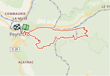
Trail Walking of 10.7 km to be discovered at Occitania, Aveyron, Peyreleau. This trail is proposed by s0c7.
Description
Beau parcours en boucle au départ de Peyreleau avec vue sur les Gorges de la Honte et la vallée du Tarn.
Belle perspective sur les vases de Chine et de Sèvre.
Chemin très agréable à parcourir.
Positioning
Country:
France
Region :
Occitania
Department/Province :
Aveyron
Municipality :
Peyreleau
Location:
Unknown
Start:(Dec)
Start:(UTM)
516695 ; 4892799 (31T) N.
Comments
Trails nearby
![Trail Walking Mostuéjouls - Cirque de Saint Marcellin - Mostuéjouls - Liaucous - Photo](https://media.geolcdn.com/t/375/260/ext.jpg?maxdim=2&url=https%3A%2F%2Fservices.sitytrail.com%2FGeolivesWS%2FDownloadMedia.ashx%3FTrailID%3D173134%26Media%3D14690_6.jpg)
![Walking Walking](https://static1.geolcdn.com/sitytour/trail-icons/101.png)
Cirque de Saint Marcellin - Mostuéjouls - Liaucous
Walking
Medium
(1)
Mostuéjouls,
Occitania,
Aveyron,
France
![](/images/other/stat-length.png)
15.4 km | 24 km-effort
5h 0min
![](https://static1.geolcdn.com/siteimages/upload/files/16400158638029165_repeat_loop_refresh_sync_direction_icon.png)
Yes
![Trail Walking Le Rozier - Causse et gorges au pays des vautours - Photo](https://media.geolcdn.com/t/375/260/ext.jpg?maxdim=2&url=https%3A%2F%2Fmedia.geolcdn.com%2Ff%2Fcab4842f-73f8-42f5-b236-9c9a4da22964.jpg)
![Walking Walking](https://static1.geolcdn.com/sitytour/trail-icons/101.png)
Causse et gorges au pays des vautours
Walking
Difficult
Le Rozier,
Occitania,
Lozère,
France
![](/images/other/stat-length.png)
27 km | 40 km-effort
7h 48min
![](https://static1.geolcdn.com/siteimages/upload/files/16400158638029165_repeat_loop_refresh_sync_direction_icon.png)
No
![Trail Walking Saint-Pierre-des-Tripiers - Cassagnes crête vallée Jonte et Tarn 12,2 km - Photo](https://media.geolcdn.com/t/375/260/ext.jpg?maxdim=2&url=https%3A%2F%2Fmedia.geolcdn.com%2Ff%2F9473c7ff-c94b-41a9-84a9-d12f53c1c0cb.jpg)
![Walking Walking](https://static1.geolcdn.com/sitytour/trail-icons/101.png)
Cassagnes crête vallée Jonte et Tarn 12,2 km
Walking
Medium
Saint-Pierre-des-Tripiers,
Occitania,
Lozère,
France
![](/images/other/stat-length.png)
12.6 km | 20 km-effort
5h 38min
![](https://static1.geolcdn.com/siteimages/upload/files/16400158638029165_repeat_loop_refresh_sync_direction_icon.png)
No
![Trail Walking Veyreau - J3 St Jean des Balmes Ermitage St Michel - Photo](https://media.geolcdn.com/t/375/260/ext.jpg?maxdim=2&url=https%3A%2F%2Fstatic1.geolcdn.com%2Fsiteimages%2Fupload%2Ffiles%2F1553511878bg_sport_marche.png)
![Walking Walking](https://static1.geolcdn.com/sitytour/trail-icons/101.png)
J3 St Jean des Balmes Ermitage St Michel
Walking
Easy
(2)
Veyreau,
Occitania,
Aveyron,
France
![](/images/other/stat-length.png)
9.6 km | 13.9 km-effort
3h 18min
![](https://static1.geolcdn.com/siteimages/upload/files/16400158638029165_repeat_loop_refresh_sync_direction_icon.png)
Yes
![Trail Walking Saint-Pierre-des-Tripiers - Les corniches du Méjean - Photo](https://media.geolcdn.com/t/375/260/ext.jpg?maxdim=2&url=https%3A%2F%2Fstatic1.geolcdn.com%2Fsiteimages%2Fupload%2Ffiles%2F1553511878bg_sport_marche.png)
![Walking Walking](https://static1.geolcdn.com/sitytour/trail-icons/101.png)
Les corniches du Méjean
Walking
Medium
(3)
Saint-Pierre-des-Tripiers,
Occitania,
Lozère,
France
![](/images/other/stat-length.png)
6 km | 9.5 km-effort
2h 31min
![](https://static1.geolcdn.com/siteimages/upload/files/16400158638029165_repeat_loop_refresh_sync_direction_icon.png)
Yes
![Trail Walking Saint-Pierre-des-Tripiers - LL34-Corniches du Méjean - Photo](https://media.geolcdn.com/t/375/260/ext.jpg?maxdim=2&url=https%3A%2F%2Fstatic1.geolcdn.com%2Fsiteimages%2Fupload%2Ffiles%2F1553511878bg_sport_marche.png)
![Walking Walking](https://static1.geolcdn.com/sitytour/trail-icons/101.png)
LL34-Corniches du Méjean
Walking
Difficult
(1)
Saint-Pierre-des-Tripiers,
Occitania,
Lozère,
France
![](/images/other/stat-length.png)
12.1 km | 25 km-effort
4h 51min
![](https://static1.geolcdn.com/siteimages/upload/files/16400158638029165_repeat_loop_refresh_sync_direction_icon.png)
Yes
![Trail Walking Saint-Pierre-des-Tripiers - vautour - Photo](https://media.geolcdn.com/t/375/260/ext.jpg?maxdim=2&url=https%3A%2F%2Fstatic1.geolcdn.com%2Fsiteimages%2Fupload%2Ffiles%2F1553511878bg_sport_marche.png)
![Walking Walking](https://static1.geolcdn.com/sitytour/trail-icons/101.png)
vautour
Walking
Medium
(1)
Saint-Pierre-des-Tripiers,
Occitania,
Lozère,
France
![](/images/other/stat-length.png)
7.1 km | 12.3 km-effort
2h 59min
![](https://static1.geolcdn.com/siteimages/upload/files/16400158638029165_repeat_loop_refresh_sync_direction_icon.png)
Yes
![Trail Walking Le Rozier - Sur Les Hauteurs De Peyreleau - Photo](https://media.geolcdn.com/t/375/260/ext.jpg?maxdim=2&url=https%3A%2F%2Fstatic1.geolcdn.com%2Fsiteimages%2Fupload%2Ffiles%2F1553511878bg_sport_marche.png)
![Walking Walking](https://static1.geolcdn.com/sitytour/trail-icons/101.png)
Sur Les Hauteurs De Peyreleau
Walking
Difficult
(2)
Le Rozier,
Occitania,
Lozère,
France
![](/images/other/stat-length.png)
10.4 km | 18.2 km-effort
4h 0min
![](https://static1.geolcdn.com/siteimages/upload/files/16400158638029165_repeat_loop_refresh_sync_direction_icon.png)
Yes
![Trail Walking Peyreleau - Le 815 - Peyreleau - Photo](https://media.geolcdn.com/t/375/260/ext.jpg?maxdim=2&url=https%3A%2F%2Fstatic1.geolcdn.com%2Fsiteimages%2Fupload%2Ffiles%2F1553511878bg_sport_marche.png)
![Walking Walking](https://static1.geolcdn.com/sitytour/trail-icons/101.png)
Le 815 - Peyreleau
Walking
Easy
(1)
Peyreleau,
Occitania,
Aveyron,
France
![](/images/other/stat-length.png)
5.5 km | 10.5 km-effort
2h 0min
![](https://static1.geolcdn.com/siteimages/upload/files/16400158638029165_repeat_loop_refresh_sync_direction_icon.png)
Yes