![](/images/other/stat-length.png)
![Trail Moto cross Réalmont - Roquecourbe, Pic de nore, Minerve - Photo](https://media.geolcdn.com/t/1900/400/e70284d5-3329-4fb7-a41a-d11af4aac54b.jpg&format=pjpeg&maxdim=2)
Roquecourbe, Pic de nore, Minerve
jpipacific
User
![Length](/images/other/stat-length.png)
Length
166 km
![Max alt](https://static1.geolcdn.com/siteimages/upload/files/1508320355ic_sort_altitude_max_24dp.png)
Max alt
1214 m
![Uphill gradient](https://static1.geolcdn.com/siteimages/upload/files/1508320355ic_sort_den_pos_24dp.png)
Uphill gradient
4405 m
![Km-Effort](/images/other/stat-length.png)
Km-Effort
225 km
![Min alt](https://static1.geolcdn.com/siteimages/upload/files/1508320355ic_sort_altitude_min_24dp.png)
Min alt
121 m
![Downhill gradient](https://static1.geolcdn.com/siteimages/upload/files/1508320355ic_sort_den_neg_24dp.png)
Downhill gradient
4495 m
![Boucle](https://static1.geolcdn.com/siteimages/upload/files/16400158638029165_repeat_loop_refresh_sync_direction_icon.png)
Boucle
No
Creation date :
2021-09-02 06:57:57.929
Updated on :
2021-09-03 12:59:51.206
![Moto cross](https://static1.geolcdn.com/sitytour/trail-icons/406.png)
6h09
Difficulty : Difficult
![Scan this QR Code to open this trail in the SityTrail application](https://capi.geolives.com/qq0zvz2zws4bq2lad0pu/sitytour/trails/2922566/qr.png?size=200)
FREE GPS app for hiking
About
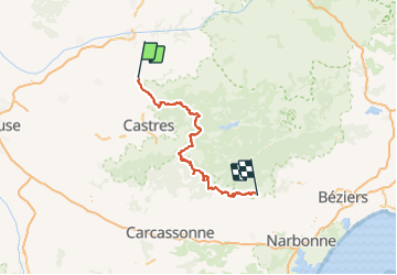
Trail Moto cross of 166 km to be discovered at Occitania, Tarn, Réalmont. This trail is proposed by jpipacific.
Description
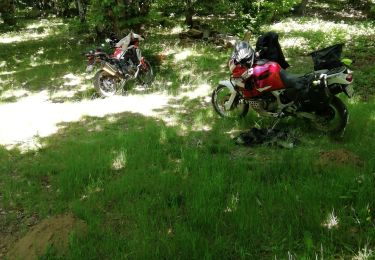
Randonnée faite avec Honda Africa Twin CRF 1000 DCT.
Une très belle randonnée.
Quelques passages un peu difficiles qui demandent de l'attention.
Quelques départs de chemin pas trop facile à trouver.
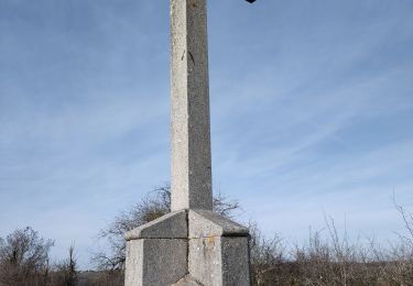
Paysages diversifiés et splendides.
Positioning
Country:
France
Region :
Occitania
Department/Province :
Tarn
Municipality :
Réalmont
Location:
Unknown
Start:(Dec)
Start:(UTM)
434608 ; 4847209 (31T) N.
Comments
Trails nearby
![Trail Walking Terre-de-Bancalié - 81_Saint Lieux Lafenasse - Photo](https://media.geolcdn.com/t/375/260/ext.jpg?maxdim=2&url=https%3A%2F%2Fstatic1.geolcdn.com%2Fsiteimages%2Fupload%2Ffiles%2F1553511878bg_sport_marche.png)
![Walking Walking](https://static1.geolcdn.com/sitytour/trail-icons/101.png)
81_Saint Lieux Lafenasse
Walking
Medium
(1)
Terre-de-Bancalié,
Occitania,
Tarn,
France
![](/images/other/stat-length.png)
18.1 km | 23 km-effort
4h 27min
![](https://static1.geolcdn.com/siteimages/upload/files/16400158638029165_repeat_loop_refresh_sync_direction_icon.png)
Yes
![Trail Moto cross Réalmont - Rando Monts de Lacaune, Laouzas, montagne noire. - Photo](https://media.geolcdn.com/t/375/260/11fc1da8-59d3-4b05-9dbc-670b2f23e8e6.jpg&format=jpg&maxdim=2)
![Moto cross Moto cross](https://static1.geolcdn.com/sitytour/trail-icons/406.png)
Rando Monts de Lacaune, Laouzas, montagne noire.
Moto cross
Difficult
Réalmont,
Occitania,
Tarn,
France
![](/images/other/stat-length.png)
178 km | 232 km-effort
4h 43min
![](https://static1.geolcdn.com/siteimages/upload/files/16400158638029165_repeat_loop_refresh_sync_direction_icon.png)
Yes
![Trail Moto cross Réalmont - Randonnée de reconnaissance Vabre St Pons - Photo](https://media.geolcdn.com/t/375/260/83189e89-3200-4ac5-ab66-38f75ce84633.jpg&format=jpg&maxdim=2)
![Moto cross Moto cross](https://static1.geolcdn.com/sitytour/trail-icons/406.png)
Randonnée de reconnaissance Vabre St Pons
Moto cross
Difficult
Réalmont,
Occitania,
Tarn,
France
![](/images/other/stat-length.png)
152 km | 202 km-effort
5h 33min
![](https://static1.geolcdn.com/siteimages/upload/files/16400158638029165_repeat_loop_refresh_sync_direction_icon.png)
No
![Trail Walking Lombers - Lombers - Photo](https://media.geolcdn.com/t/375/260/b0a7a518-d2a1-49cb-8c54-d41b2957fa13.jpg&format=jpg&maxdim=2)
![Walking Walking](https://static1.geolcdn.com/sitytour/trail-icons/101.png)
![Trail Moto cross Réalmont - Balade de juillet montagne noire - Photo](https://media.geolcdn.com/t/375/260/4e6c59cc-6840-4f1a-aa0a-11fa3c2db325.jpg&format=jpg&maxdim=2)
![Moto cross Moto cross](https://static1.geolcdn.com/sitytour/trail-icons/406.png)
Balade de juillet montagne noire
Moto cross
Easy
Réalmont,
Occitania,
Tarn,
France
![](/images/other/stat-length.png)
235 km | 307 km-effort
6h 0min
![](https://static1.geolcdn.com/siteimages/upload/files/16400158638029165_repeat_loop_refresh_sync_direction_icon.png)
Yes
![Trail Moto cross Réalmont - Ballade dans le parc du haut languedoc - Photo](https://media.geolcdn.com/t/375/260/68fa449d-4b95-401c-b792-98cdcd4b6c01.jpg&format=jpg&maxdim=2)
![Moto cross Moto cross](https://static1.geolcdn.com/sitytour/trail-icons/406.png)
Ballade dans le parc du haut languedoc
Moto cross
Medium
Réalmont,
Occitania,
Tarn,
France
![](/images/other/stat-length.png)
275 km | 358 km-effort
7h 43min
![](https://static1.geolcdn.com/siteimages/upload/files/16400158638029165_repeat_loop_refresh_sync_direction_icon.png)
No
![Trail Walking Terre-de-Bancalié - 2023-01-25_07h53m46_Cirkwi-Chemin_Des_Mineurs - Photo](https://media.geolcdn.com/t/375/260/ext.jpg?maxdim=2&url=https%3A%2F%2Fstatic1.geolcdn.com%2Fsiteimages%2Fupload%2Ffiles%2F1553511878bg_sport_marche.png)
![Walking Walking](https://static1.geolcdn.com/sitytour/trail-icons/101.png)
2023-01-25_07h53m46_Cirkwi-Chemin_Des_Mineurs
Walking
Difficult
Terre-de-Bancalié,
Occitania,
Tarn,
France
![](/images/other/stat-length.png)
10.4 km | 14 km-effort
3h 11min
![](https://static1.geolcdn.com/siteimages/upload/files/16400158638029165_repeat_loop_refresh_sync_direction_icon.png)
Yes
![Trail Walking Lombers - Lombers formation - Photo](https://media.geolcdn.com/t/375/260/ext.jpg?maxdim=2&url=https%3A%2F%2Fstatic1.geolcdn.com%2Fsiteimages%2Fupload%2Ffiles%2F1553511878bg_sport_marche.png)
![Walking Walking](https://static1.geolcdn.com/sitytour/trail-icons/101.png)
Lombers formation
Walking
Very easy
Lombers,
Occitania,
Tarn,
France
![](/images/other/stat-length.png)
6.4 km | 8.5 km-effort
1h 59min
![](https://static1.geolcdn.com/siteimages/upload/files/16400158638029165_repeat_loop_refresh_sync_direction_icon.png)
Yes
![Trail Motorbike Réalmont - rando 2 - Photo](https://media.geolcdn.com/t/375/260/ext.jpg?maxdim=2&url=https%3A%2F%2Fstatic1.geolcdn.com%2Fsiteimages%2Fupload%2Ffiles%2F1524743155moto.jpg)
![Motorbike Motorbike](https://static1.geolcdn.com/sitytour/trail-icons/402.png)