![](/images/other/stat-length.png)
![Trail Walking Chaumes-en-Retz - TraceGPS Issued Circuit des iles enchantees - Chemere - Photo](https://media.geolcdn.com/t/1900/400/ext.pjpeg?maxdim=2&url=https%3A%2F%2Fstatic1.geolcdn.com%2Fsiteimages%2Fupload%2Ffiles%2F1553511878bg_sport_marche.png)
TraceGPS Issued Circuit des iles enchantees - Chemere
neoroll44
User
![Length](/images/other/stat-length.png)
![Max alt](https://static1.geolcdn.com/siteimages/upload/files/1508320355ic_sort_altitude_max_24dp.png)
![Uphill gradient](https://static1.geolcdn.com/siteimages/upload/files/1508320355ic_sort_den_pos_24dp.png)
![Km-Effort](/images/other/stat-length.png)
![Min alt](https://static1.geolcdn.com/siteimages/upload/files/1508320355ic_sort_altitude_min_24dp.png)
![Downhill gradient](https://static1.geolcdn.com/siteimages/upload/files/1508320355ic_sort_den_neg_24dp.png)
![Boucle](https://static1.geolcdn.com/siteimages/upload/files/16400158638029165_repeat_loop_refresh_sync_direction_icon.png)
![Walking](https://static1.geolcdn.com/sitytour/trail-icons/101.png)
7h00
Difficulty : Difficult
![Cycle](https://static1.geolcdn.com/sitytour/trail-icons/200.png)
2h00
Difficulty : Easy
![Scan this QR Code to open this trail in the SityTrail application](https://capi.geolives.com/qq0zvz2zws4bq2lad0pu/sitytour/trails/2922394/qr.png?size=200)
FREE GPS app for hiking
About
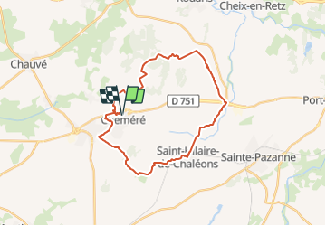
Trail Walking of 28 km to be discovered at Pays de la Loire, Loire-Atlantique, Chaumes-en-Retz. This trail is proposed by neoroll44.
Description
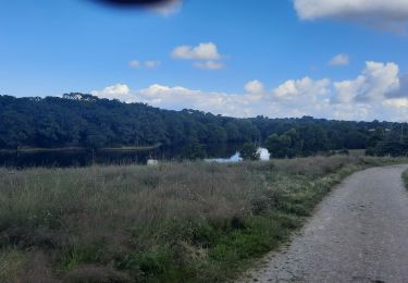
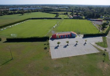
Départ du parc de loisirs dans le bourg de Chéméré qui à fusionnée avec Arthon-en-Retz pour former Chaumes-en-Retz. Découvrez de nombreux sites ayant marqué l’histoire de Pays de Retz : les ruines du Château de Princé, les Iles Enchantées aménagées au 17e siècle par Henri De Gondi, la forêt de Princé avec son calvaire édifié à la mémoire des massacres des guerres de Vendée. A 300 m du calvaire, découvrez le Menhir de la Pierre Levée. Après le Pont Béranger, admirez le château du Bois Rouaud avec sa toiture en forme de casque à pointe, et plus loin le calvaire de St Hilaire de Chaléons.
Positioning
Comments
Trails nearby
![Trail On foot Saint-Hilaire-de-Chaléons - Circuit des Templiers - Photo](https://media.geolcdn.com/t/375/260/d2ec675e-afb6-4d2c-b141-de8dacdba4f4.jpeg&format=jpg&maxdim=2)
![On foot On foot](https://static1.geolcdn.com/sitytour/trail-icons/100.png)
On foot
![](/images/other/stat-length.png)
![](https://static1.geolcdn.com/siteimages/upload/files/16400158638029165_repeat_loop_refresh_sync_direction_icon.png)
![Trail On foot Chaumes-en-Retz - Sentier pédestre des Iles Enchantées - Photo](https://media.geolcdn.com/t/375/260/8d9b3652-bedc-4903-8d23-e450b9c65d96.jpeg&format=jpg&maxdim=2)
![On foot On foot](https://static1.geolcdn.com/sitytour/trail-icons/100.png)
On foot
![](/images/other/stat-length.png)
![](https://static1.geolcdn.com/siteimages/upload/files/16400158638029165_repeat_loop_refresh_sync_direction_icon.png)
![Trail On foot Chaumes-en-Retz - Circuit des Chênes - Photo](https://media.geolcdn.com/t/375/260/7606bf5a-2198-4218-abf5-a4d4ae02cf42.jpeg&format=jpg&maxdim=2)
![On foot On foot](https://static1.geolcdn.com/sitytour/trail-icons/100.png)
On foot
![](/images/other/stat-length.png)
![](https://static1.geolcdn.com/siteimages/upload/files/16400158638029165_repeat_loop_refresh_sync_direction_icon.png)
![Trail Walking Chaumes-en-Retz - Arthon Chemere - Photo](https://media.geolcdn.com/t/375/260/5c2166da-4a74-4ba7-a499-c7af068420f8.jpg&format=jpg&maxdim=2)
![Walking Walking](https://static1.geolcdn.com/sitytour/trail-icons/101.png)
Walking
![](/images/other/stat-length.png)
![](https://static1.geolcdn.com/siteimages/upload/files/16400158638029165_repeat_loop_refresh_sync_direction_icon.png)
![Trail Mountain bike Chaumes-en-Retz - de Arthon en Retz par le Prépaud - Photo](https://media.geolcdn.com/t/375/260/ext.jpg?maxdim=2&url=https%3A%2F%2Fstatic1.geolcdn.com%2Fsiteimages%2Fupload%2Ffiles%2F1524743154velo.jpg)
![Mountain bike Mountain bike](https://static1.geolcdn.com/sitytour/trail-icons/202.png)
Mountain bike
![](/images/other/stat-length.png)
![](https://static1.geolcdn.com/siteimages/upload/files/16400158638029165_repeat_loop_refresh_sync_direction_icon.png)
![Trail Hybrid bike Chaumes-en-Retz - Belle Épine lac de Pornic - Photo](https://media.geolcdn.com/t/375/260/4196bce5-8058-43cf-9aa2-712e6b61de2a.jpg&format=jpg&maxdim=2)
![Hybrid bike Hybrid bike](https://static1.geolcdn.com/sitytour/trail-icons/203.png)
Hybrid bike
![](/images/other/stat-length.png)
![](https://static1.geolcdn.com/siteimages/upload/files/16400158638029165_repeat_loop_refresh_sync_direction_icon.png)
![Trail On foot Chaumes-en-Retz - D'Arthon à La Sicaudais - Photo](https://media.geolcdn.com/t/375/260/39754271-52c4-4067-8a63-e67370b7bbbe.jpeg&format=jpg&maxdim=2)
![On foot On foot](https://static1.geolcdn.com/sitytour/trail-icons/100.png)
On foot
![](/images/other/stat-length.png)
![](https://static1.geolcdn.com/siteimages/upload/files/16400158638029165_repeat_loop_refresh_sync_direction_icon.png)
![Trail On foot Chaumes-en-Retz - Circuit de Haute-Perche - Photo](https://media.geolcdn.com/t/375/260/39754271-52c4-4067-8a63-e67370b7bbbe.jpeg&format=jpg&maxdim=2)
![On foot On foot](https://static1.geolcdn.com/sitytour/trail-icons/100.png)
On foot
![](/images/other/stat-length.png)
![](https://static1.geolcdn.com/siteimages/upload/files/16400158638029165_repeat_loop_refresh_sync_direction_icon.png)
![Trail Mountain bike Chaumes-en-Retz - Belle épine/Ste Pazane - Photo](https://media.geolcdn.com/t/375/260/91857525-f683-4e66-91a0-3b82395a892f.jpg&format=jpg&maxdim=2)
![Mountain bike Mountain bike](https://static1.geolcdn.com/sitytour/trail-icons/202.png)
Mountain bike
![](/images/other/stat-length.png)
![](https://static1.geolcdn.com/siteimages/upload/files/16400158638029165_repeat_loop_refresh_sync_direction_icon.png)