Trail Running Toul - Gne - Photo
© OpenStreetMap contributors
Length
Length
3.9 km
Max alt
Max alt
305 m
Uphill gradient
Uphill gradient
97 m
Km-Effort
Km-Effort  
5.1 km
Min alt
Min alt
224 m
Downhill gradient
Downhill gradient
73 m
Boucle
Boucle
No
Creation date :
2021-08-30 16:38:24.0
Updated on :
2021-08-30 17:06:56.044

(0 Reviews)

Running
Running
26m
Difficulty : Very easy

Scan this QR Code to open this trail in the SityTrail application

FREE GPS app for hiking

Logo SityTrail SityTrail

IGN / Geographical institutes

Download SityTrail from the App Store Download SityTrail from Google Play

Logo SityTrail SityTrail World

The world is yours!

Download SityTrail from the App Store Download SityTrail from Google Play Download SityTrail on Huawei AppGallery

About

Trail Running of 3.9 km to be discovered at Grand Est, Meurthe-et-Moselle, Toul. This trail is proposed by Octave Daburon.

Description

Je me suis arrêté en cours de chemin 22m00 au dernier checkpoint

-fourmi dans le pied droit

Elevation profile

Positioning

Country:
France
Region :
Grand Est
Department/Province :
Meurthe-et-Moselle
Municipality :
Toul
Location:
Unknown
Start:(UTM)
712932 ; 5396548 (31U) N.

Trails nearby

Trail On foot Bruley - Circuit de la Petite Linotte - Photo
On foot
GUIDE+

On foot

Easy
Bruley, Grand Est, Meurthe-et-Moselle, France
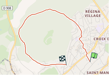
9.2 km | 12 km-effort
2h 43min
No
Trail Mountain bike Toul - Côtes de Toul 50k 2012 - Photo
Mountain bike
virginieHurpeau

Mountain bike

Difficult
(2)
Toul, Grand Est, Meurthe-et-Moselle, France
59 km | 75 km-effort
5h 15min
Yes
Trail Mountain bike Écrouves - 1 ère rando VTT - Photo
Mountain bike
ericsnoopy

Mountain bike

Very easy
(1)
Écrouves, Grand Est, Meurthe-et-Moselle, France
7.5 km | 9.5 km-effort
Unknown
Yes
Trail On foot Choloy-Ménillot - Boucle des Sources - Photo
On foot
GUIDE+

On foot

Easy
Choloy-Ménillot, Grand Est, Meurthe-et-Moselle, France
10.4 km | 11.9 km-effort
2h 42min
No
Trail On foot Lucey - Circuit des Vignes - Photo
On foot
GUIDE+

On foot

Easy
Lucey, Grand Est, Meurthe-et-Moselle, France
4.2 km | 5.2 km-effort
1h 11min
Yes
Trail On foot Dommartin-lès-Toul - Circuit du Luxembourg - Photo
On foot
GUIDE+

On foot

Easy
Dommartin-lès-Toul, Grand Est, Meurthe-et-Moselle, France
12.5 km | 15.3 km-effort
3h 28min
No
Trail On foot Pagney-derrière-Barine - Circuit du Val des Nonnes - Photo
On foot
GUIDE+

On foot

Easy
Pagney-derrière-Barine, Grand Est, Meurthe-et-Moselle, France
14.9 km | 19 km-effort
4h 19min
Yes
Trail On foot Chaudeney-sur-Moselle - Circuit du Bois Gaillard - Photo
On foot
GUIDE+

On foot

Easy
Chaudeney-sur-Moselle, Grand Est, Meurthe-et-Moselle, France
6.6 km | 7.5 km-effort
1h 42min
Yes
Trail On foot Écrouves - Sentier Toul-Thiaucourt - Photo
On foot
GUIDE+

On foot

Medium
Écrouves, Grand Est, Meurthe-et-Moselle, France
22 km | 24 km-effort
5h 28min
No


Close
My subscriptions