![](/images/other/stat-length.png)
![Trail Walking Vallehermoso - Canaries - La Gomera - Vallehermoso/Santa Clara - jour 8 - Photo](https://media.geolcdn.com/t/1900/400/ext.pjpeg?maxdim=2&url=https%3A%2F%2Fstatic1.geolcdn.com%2Fsiteimages%2Fupload%2Ffiles%2F1553511878bg_sport_marche.png)
Canaries - La Gomera - Vallehermoso/Santa Clara - jour 8
fhascoet
User
![Length](/images/other/stat-length.png)
![Max alt](https://static1.geolcdn.com/siteimages/upload/files/1508320355ic_sort_altitude_max_24dp.png)
![Uphill gradient](https://static1.geolcdn.com/siteimages/upload/files/1508320355ic_sort_den_pos_24dp.png)
![Km-Effort](/images/other/stat-length.png)
![Min alt](https://static1.geolcdn.com/siteimages/upload/files/1508320355ic_sort_altitude_min_24dp.png)
![Downhill gradient](https://static1.geolcdn.com/siteimages/upload/files/1508320355ic_sort_den_neg_24dp.png)
![Boucle](https://static1.geolcdn.com/siteimages/upload/files/16400158638029165_repeat_loop_refresh_sync_direction_icon.png)
![Walking](https://static1.geolcdn.com/sitytour/trail-icons/101.png)
6h30
Difficulty : Difficult
![Scan this QR Code to open this trail in the SityTrail application](https://capi.geolives.com/qq0zvz2zws4bq2lad0pu/sitytour/trails/2917646/qr.png?size=200)
FREE GPS app for hiking
About
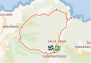
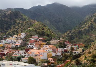
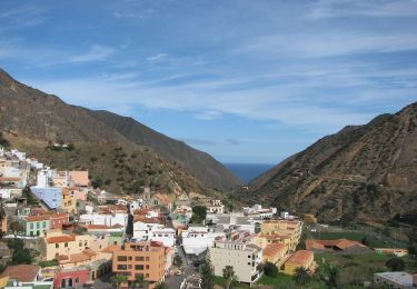
Trail Walking of 14.1 km to be discovered at Canary Islands, Santa Cruz de Tenerife, Vallehermoso. This trail is proposed by fhascoet.
Description
Montée en quittant le village vers le bel espace aménagé à l'ermitage de Santa Clara.
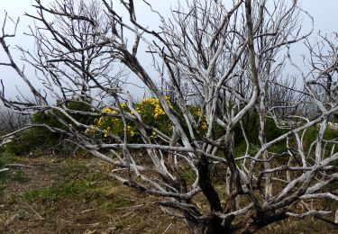
Randonnée facile sur la crète avec de beaux points de vue
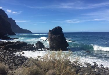
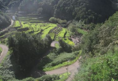
Puis descente très raide vers la plage où une superbe piscine d'eau de mer vous attend.
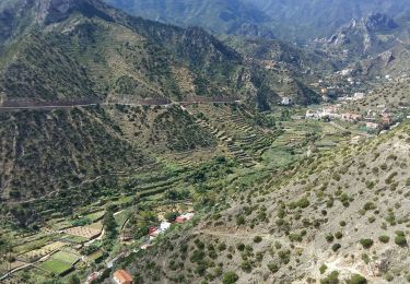
Retour vers Vallehermoso par un chemin qui longe le fond de la vallée, a travers les plantations.
Durée avec arret déjeuner compris
Positioning
Comments
Trails nearby
![Trail Walking Vallehermoso - gomera taso - Photo](https://media.geolcdn.com/t/375/260/ext.jpg?maxdim=2&url=https%3A%2F%2Fservices.sitytrail.com%2FGeolivesWS%2FDownloadMedia.ashx%3FTrailID%3D480545%26Media%3D20151008113700.jpg)
![Walking Walking](https://static1.geolcdn.com/sitytour/trail-icons/101.png)
Walking
![](/images/other/stat-length.png)
![](https://static1.geolcdn.com/siteimages/upload/files/16400158638029165_repeat_loop_refresh_sync_direction_icon.png)
![Trail On foot Vallehermoso - Ruta 04 - Photo](https://media.geolcdn.com/t/375/260/877b4429-1a8a-4993-91f0-1f9ba1237b8e.jpeg&format=jpg&maxdim=2)
![On foot On foot](https://static1.geolcdn.com/sitytour/trail-icons/100.png)
On foot
![](/images/other/stat-length.png)
![](https://static1.geolcdn.com/siteimages/upload/files/16400158638029165_repeat_loop_refresh_sync_direction_icon.png)
![Trail Walking Vallehermoso - La Gomera - Valhermoso Santa Clara (4) 8/5/2019 - Photo](https://media.geolcdn.com/t/375/260/30434ec8-9caa-4226-b188-f68ed5492556.jpg&format=jpg&maxdim=2)
![Walking Walking](https://static1.geolcdn.com/sitytour/trail-icons/101.png)
Walking
![](/images/other/stat-length.png)
![](https://static1.geolcdn.com/siteimages/upload/files/16400158638029165_repeat_loop_refresh_sync_direction_icon.png)
![Trail Walking Vallehermoso - gomera taso - Photo](https://media.geolcdn.com/t/375/260/ext.jpg?maxdim=2&url=https%3A%2F%2Fservices.sitytrail.com%2FGeolivesWS%2FDownloadMedia.ashx%3FTrailID%3D1110143%26Media%3D20151008113700.jpg)
![Walking Walking](https://static1.geolcdn.com/sitytour/trail-icons/101.png)
Walking
![](/images/other/stat-length.png)
![](https://static1.geolcdn.com/siteimages/upload/files/16400158638029165_repeat_loop_refresh_sync_direction_icon.png)
![Trail On foot Vallehermoso - Ruta 38 - Photo](https://media.geolcdn.com/t/375/260/a5114c43-9390-43db-ae2f-f55e2339105d.jpeg&format=jpg&maxdim=2)
![On foot On foot](https://static1.geolcdn.com/sitytour/trail-icons/100.png)
On foot
![](/images/other/stat-length.png)
![](https://static1.geolcdn.com/siteimages/upload/files/16400158638029165_repeat_loop_refresh_sync_direction_icon.png)
![Trail On foot Hermigua - Reventón Oscuro - El Cedro - Photo](https://media.geolcdn.com/t/375/260/894e2729-5fef-471c-801f-1eaa4ed76d4c.jpeg&format=jpg&maxdim=2)
![On foot On foot](https://static1.geolcdn.com/sitytour/trail-icons/100.png)
On foot
![](/images/other/stat-length.png)
![](https://static1.geolcdn.com/siteimages/upload/files/16400158638029165_repeat_loop_refresh_sync_direction_icon.png)
![Trail On foot Hermigua - Ruta 9: El Contadero - Chorro del Cedro - Photo](https://media.geolcdn.com/t/375/260/170a792b-f466-4df4-95eb-754e8c2f554c.jpeg&format=jpg&maxdim=2)
![On foot On foot](https://static1.geolcdn.com/sitytour/trail-icons/100.png)
On foot
![](/images/other/stat-length.png)
![](https://static1.geolcdn.com/siteimages/upload/files/16400158638029165_repeat_loop_refresh_sync_direction_icon.png)
![Trail On foot Hermigua - Ruta 11: La Meseta de Hermigua - Chorro del Cedro - Photo](https://media.geolcdn.com/t/375/260/9ee5583b-8203-4e03-a5fc-f7ea80c15335.jpeg&format=jpg&maxdim=2)
![On foot On foot](https://static1.geolcdn.com/sitytour/trail-icons/100.png)
On foot
![](/images/other/stat-length.png)
![](https://static1.geolcdn.com/siteimages/upload/files/16400158638029165_repeat_loop_refresh_sync_direction_icon.png)
![Trail On foot Valle Gran Rey - Cañada de Jorge - Photo](https://media.geolcdn.com/t/375/260/579162eb-caab-490a-aca6-b48da9d89d76.jpeg&format=jpg&maxdim=2)
![On foot On foot](https://static1.geolcdn.com/sitytour/trail-icons/100.png)
On foot
![](/images/other/stat-length.png)
![](https://static1.geolcdn.com/siteimages/upload/files/16400158638029165_repeat_loop_refresh_sync_direction_icon.png)