![](/images/other/stat-length.png)
![Trail Walking Hermigua - Canaries - La Gomera - El Cedro - jour 7 - Photo](https://media.geolcdn.com/t/1900/400/7697a606-f099-4be7-9c1b-9518519b3af3.jpg&format=pjpeg&maxdim=2)
Canaries - La Gomera - El Cedro - jour 7
fhascoet
User
![Length](/images/other/stat-length.png)
Length
9.4 km
![Max alt](https://static1.geolcdn.com/siteimages/upload/files/1508320355ic_sort_altitude_max_24dp.png)
Max alt
999 m
![Uphill gradient](https://static1.geolcdn.com/siteimages/upload/files/1508320355ic_sort_den_pos_24dp.png)
Uphill gradient
584 m
![Km-Effort](/images/other/stat-length.png)
Km-Effort
17.2 km
![Min alt](https://static1.geolcdn.com/siteimages/upload/files/1508320355ic_sort_altitude_min_24dp.png)
Min alt
489 m
![Downhill gradient](https://static1.geolcdn.com/siteimages/upload/files/1508320355ic_sort_den_neg_24dp.png)
Downhill gradient
584 m
![Boucle](https://static1.geolcdn.com/siteimages/upload/files/16400158638029165_repeat_loop_refresh_sync_direction_icon.png)
Boucle
Yes
Creation date :
2021-08-28 09:17:01.082
Updated on :
2021-09-06 17:31:42.976
![Walking](https://static1.geolcdn.com/sitytour/trail-icons/101.png)
5h30
Difficulty : Medium
![Scan this QR Code to open this trail in the SityTrail application](https://capi.geolives.com/qq0zvz2zws4bq2lad0pu/sitytour/trails/2915988/qr.png?size=200)
FREE GPS app for hiking
About
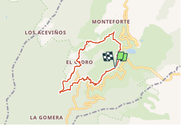
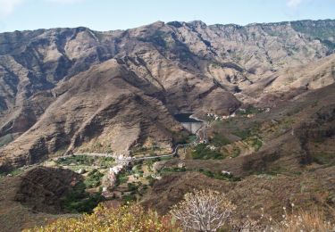
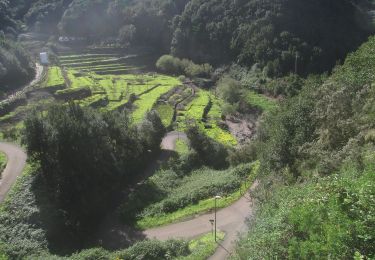
Trail Walking of 9.4 km to be discovered at Canary Islands, Santa Cruz de Tenerife, Hermigua. This trail is proposed by fhascoet.
Description
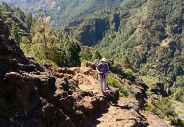
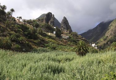
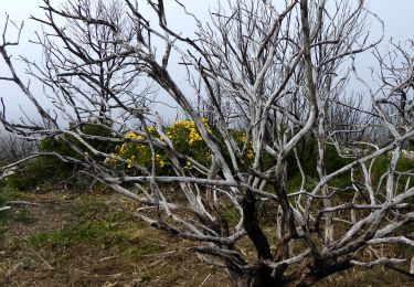
Randonnée très agréable dans la foret de lauriers et de bruyères arborescentes
Jolie cascade après la retenue d'eau.
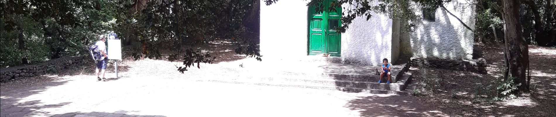
L'ermitage de Lourdes au sud est un endroit joli et très fréquenté avec des tables pour dejeuner.
Positioning
Country:
Spain
Region :
Canary Islands
Department/Province :
Santa Cruz de Tenerife
Municipality :
Hermigua
Location:
Unknown
Start:(Dec)
Start:(UTM)
283727 ; 3114051 (28R) N.
Comments
Trails nearby
![Trail Walking Hermigua - Ibo Alvaro - Vallehermoso - Photo](https://media.geolcdn.com/t/375/260/dde858dd-4e70-43e2-9f8b-6a43896be5d6.jpg&format=jpg&maxdim=2)
![Walking Walking](https://static1.geolcdn.com/sitytour/trail-icons/101.png)
Ibo Alvaro - Vallehermoso
Walking
Difficult
Hermigua,
Canary Islands,
Santa Cruz de Tenerife,
Spain
![](/images/other/stat-length.png)
16.9 km | 31 km-effort
6h 25min
![](https://static1.geolcdn.com/siteimages/upload/files/16400158638029165_repeat_loop_refresh_sync_direction_icon.png)
No
![Trail Walking San Sebastián de la Gomera - La Gomera - La Zarcita la Laja el Bailadero 7/5/2019 - Photo](https://media.geolcdn.com/t/375/260/f8d4614d-4c66-4ecc-89c4-7f24d5cd179e.jpg&format=jpg&maxdim=2)
![Walking Walking](https://static1.geolcdn.com/sitytour/trail-icons/101.png)
La Gomera - La Zarcita la Laja el Bailadero 7/5/2019
Walking
Medium
San Sebastián de la Gomera,
Canary Islands,
Santa Cruz de Tenerife,
Spain
![](/images/other/stat-length.png)
8.7 km | 17.8 km-effort
3h 39min
![](https://static1.geolcdn.com/siteimages/upload/files/16400158638029165_repeat_loop_refresh_sync_direction_icon.png)
Yes
![Trail On foot San Sebastián de la Gomera - Ruta 31 - Photo](https://media.geolcdn.com/t/375/260/a2ad51f1-33e3-4b11-a53c-eb0fc685fb27.jpeg&format=jpg&maxdim=2)
![On foot On foot](https://static1.geolcdn.com/sitytour/trail-icons/100.png)
Ruta 31
On foot
Easy
San Sebastián de la Gomera,
Canary Islands,
Santa Cruz de Tenerife,
Spain
![](/images/other/stat-length.png)
5.1 km | 9.4 km-effort
2h 7min
![](https://static1.geolcdn.com/siteimages/upload/files/16400158638029165_repeat_loop_refresh_sync_direction_icon.png)
No
![Trail On foot Hermigua - Ruta 37 - Photo](https://media.geolcdn.com/t/375/260/86efd7c3-9675-4951-afc6-abaa1b072042.jpeg&format=jpg&maxdim=2)
![On foot On foot](https://static1.geolcdn.com/sitytour/trail-icons/100.png)
Ruta 37
On foot
Easy
Hermigua,
Canary Islands,
Santa Cruz de Tenerife,
Spain
![](/images/other/stat-length.png)
3.2 km | 8.5 km-effort
1h 56min
![](https://static1.geolcdn.com/siteimages/upload/files/16400158638029165_repeat_loop_refresh_sync_direction_icon.png)
No
![Trail On foot Agulo - PR LG 3 - Photo](https://media.geolcdn.com/t/375/260/afef9a1d-8886-4d58-be0c-78363cbd237a.jpeg&format=jpg&maxdim=2)
![On foot On foot](https://static1.geolcdn.com/sitytour/trail-icons/100.png)
PR LG 3
On foot
Easy
Agulo,
Canary Islands,
Santa Cruz de Tenerife,
Spain
![](/images/other/stat-length.png)
5.2 km | 7 km-effort
1h 35min
![](https://static1.geolcdn.com/siteimages/upload/files/16400158638029165_repeat_loop_refresh_sync_direction_icon.png)
No
![Trail On foot Hermigua - Ruta 32 - Photo](https://media.geolcdn.com/t/375/260/91c0beb8-ab87-4461-86a4-75e9d6c23f39.jpeg&format=jpg&maxdim=2)
![On foot On foot](https://static1.geolcdn.com/sitytour/trail-icons/100.png)
Ruta 32
On foot
Easy
Hermigua,
Canary Islands,
Santa Cruz de Tenerife,
Spain
![](/images/other/stat-length.png)
4.4 km | 6.4 km-effort
1h 26min
![](https://static1.geolcdn.com/siteimages/upload/files/16400158638029165_repeat_loop_refresh_sync_direction_icon.png)
No
![Trail On foot Hermigua - Ruta 33 - Photo](https://media.geolcdn.com/t/375/260/cf4876e3-19d3-4520-8999-19226e345e35.jpeg&format=jpg&maxdim=2)
![On foot On foot](https://static1.geolcdn.com/sitytour/trail-icons/100.png)
Ruta 33
On foot
Easy
Hermigua,
Canary Islands,
Santa Cruz de Tenerife,
Spain
![](/images/other/stat-length.png)
5.1 km | 8.5 km-effort
1h 56min
![](https://static1.geolcdn.com/siteimages/upload/files/16400158638029165_repeat_loop_refresh_sync_direction_icon.png)
No
![Trail On foot Hermigua - Reventón Oscuro - El Cedro - Photo](https://media.geolcdn.com/t/375/260/894e2729-5fef-471c-801f-1eaa4ed76d4c.jpeg&format=jpg&maxdim=2)
![On foot On foot](https://static1.geolcdn.com/sitytour/trail-icons/100.png)
Reventón Oscuro - El Cedro
On foot
Easy
Hermigua,
Canary Islands,
Santa Cruz de Tenerife,
Spain
![](/images/other/stat-length.png)
3.2 km | 6.3 km-effort
1h 25min
![](https://static1.geolcdn.com/siteimages/upload/files/16400158638029165_repeat_loop_refresh_sync_direction_icon.png)
No
![Trail On foot Hermigua - Ruta 9: El Contadero - Chorro del Cedro - Photo](https://media.geolcdn.com/t/375/260/170a792b-f466-4df4-95eb-754e8c2f554c.jpeg&format=jpg&maxdim=2)
![On foot On foot](https://static1.geolcdn.com/sitytour/trail-icons/100.png)
Ruta 9: El Contadero - Chorro del Cedro
On foot
Easy
Hermigua,
Canary Islands,
Santa Cruz de Tenerife,
Spain
![](/images/other/stat-length.png)
5.8 km | 11.4 km-effort
2h 35min
![](https://static1.geolcdn.com/siteimages/upload/files/16400158638029165_repeat_loop_refresh_sync_direction_icon.png)
No