![](/images/other/stat-length.png)
![Trail On foot Lésigny - SityTrail - R 14 - R13 Modifié - 8.76km bois notre dame - Photo](https://media.geolcdn.com/t/1900/400/ext.pjpeg?maxdim=2&url=https%3A%2F%2Fstatic1.geolcdn.com%2Fsiteimages%2Fupload%2Ffiles%2F1545311037marcheuse_200dpi.jpg)
SityTrail - R 14 - R13 Modifié - 8.76km bois notre dame
Les 1000 pattes
Club randonnées SERVON
![Length](/images/other/stat-length.png)
Length
8.1 km
![Max alt](https://static1.geolcdn.com/siteimages/upload/files/1508320355ic_sort_altitude_max_24dp.png)
Max alt
109 m
![Uphill gradient](https://static1.geolcdn.com/siteimages/upload/files/1508320355ic_sort_den_pos_24dp.png)
Uphill gradient
45 m
![Km-Effort](/images/other/stat-length.png)
Km-Effort
8.7 km
![Min alt](https://static1.geolcdn.com/siteimages/upload/files/1508320355ic_sort_altitude_min_24dp.png)
Min alt
98 m
![Downhill gradient](https://static1.geolcdn.com/siteimages/upload/files/1508320355ic_sort_den_neg_24dp.png)
Downhill gradient
45 m
![Boucle](https://static1.geolcdn.com/siteimages/upload/files/16400158638029165_repeat_loop_refresh_sync_direction_icon.png)
Boucle
Yes
Creation date :
2021-07-09 13:17:44.904
Updated on :
2023-06-21 15:36:35.186
![On foot](https://static1.geolcdn.com/sitytour/trail-icons/100.png)
1h30
Difficulty : Very difficult
![Scan this QR Code to open this trail in the SityTrail application](https://capi.geolives.com/qq0zvz2zws4bq2lad0pu/sitytour/trails/2915774/qr.png?size=200)
FREE GPS app for hiking
About
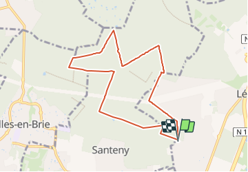
Trail On foot of 8.1 km to be discovered at Ile-de-France, Seine-et-Marne, Lésigny. This trail is proposed by Les 1000 pattes.
Description
Voiture jusqu'au parking Rue du Lys à Santeny ( Château d'eau du domaine : Ville-Jardin de Grattepeau )
Positioning
Country:
France
Region :
Ile-de-France
Department/Province :
Seine-et-Marne
Municipality :
Lésigny
Location:
Unknown
Start:(Dec)
Start:(UTM)
470280 ; 5398223 (31U) N.
Comments
Trails nearby
![Trail On foot Marolles-en-Brie - L 48 Les Bagaudes et parcours sportif de Sucy 5,7 km - Photo](https://media.geolcdn.com/t/375/260/ext.jpg?maxdim=2&url=https%3A%2F%2Fstatic1.geolcdn.com%2Fsiteimages%2Fupload%2Ffiles%2F1545311037marcheuse_200dpi.jpg)
![On foot On foot](https://static1.geolcdn.com/sitytour/trail-icons/100.png)
L 48 Les Bagaudes et parcours sportif de Sucy 5,7 km
On foot
Very easy
(5)
Marolles-en-Brie,
Ile-de-France,
Val-de-Marne,
France
![](/images/other/stat-length.png)
6 km | 6.6 km-effort
1h 29min
![](https://static1.geolcdn.com/siteimages/upload/files/16400158638029165_repeat_loop_refresh_sync_direction_icon.png)
Yes
![Trail Walking Servon - J 22 12.00 km Lésigny intempéries - Photo](https://media.geolcdn.com/t/375/260/ext.jpg?maxdim=2&url=https%3A%2F%2Fstatic1.geolcdn.com%2Fsiteimages%2Fupload%2Ffiles%2F1553511878bg_sport_marche.png)
![Walking Walking](https://static1.geolcdn.com/sitytour/trail-icons/101.png)
J 22 12.00 km Lésigny intempéries
Walking
Medium
(5)
Servon,
Ile-de-France,
Seine-et-Marne,
France
![](/images/other/stat-length.png)
12.6 km | 14.2 km-effort
3h 10min
![](https://static1.geolcdn.com/siteimages/upload/files/16400158638029165_repeat_loop_refresh_sync_direction_icon.png)
Yes
![Trail On foot Lésigny - L 14 5.5 km boucle autour de L'orée de lésigny - Photo](https://media.geolcdn.com/t/375/260/ext.jpg?maxdim=2&url=https%3A%2F%2Fstatic1.geolcdn.com%2Fsiteimages%2Fupload%2Ffiles%2F1545311037marcheuse_200dpi.jpg)
![On foot On foot](https://static1.geolcdn.com/sitytour/trail-icons/100.png)
L 14 5.5 km boucle autour de L'orée de lésigny
On foot
Very easy
(5)
Lésigny,
Ile-de-France,
Seine-et-Marne,
France
![](/images/other/stat-length.png)
5.8 km | 6.2 km-effort
1h 24min
![](https://static1.geolcdn.com/siteimages/upload/files/16400158638029165_repeat_loop_refresh_sync_direction_icon.png)
Yes
![Trail On foot Villecresnes - L 20 boucle golf villecresnes et ancienne voie de chemin de fer - Photo](https://media.geolcdn.com/t/375/260/ext.jpg?maxdim=2&url=https%3A%2F%2Fstatic1.geolcdn.com%2Fsiteimages%2Fupload%2Ffiles%2F1545311037marcheuse_200dpi.jpg)
![On foot On foot](https://static1.geolcdn.com/sitytour/trail-icons/100.png)
L 20 boucle golf villecresnes et ancienne voie de chemin de fer
On foot
Very easy
(6)
Villecresnes,
Ile-de-France,
Val-de-Marne,
France
![](/images/other/stat-length.png)
6.5 km | 7.7 km-effort
1h 44min
![](https://static1.geolcdn.com/siteimages/upload/files/16400158638029165_repeat_loop_refresh_sync_direction_icon.png)
Yes
![Trail On foot Servon - nom_fic (49) - Photo](https://media.geolcdn.com/t/375/260/b5894e46-d1cd-485b-a28c-446d5e91d239.jpg&format=jpg&maxdim=2)
![On foot On foot](https://static1.geolcdn.com/sitytour/trail-icons/100.png)
nom_fic (49)
On foot
Very easy
(6)
Servon,
Ile-de-France,
Seine-et-Marne,
France
![](/images/other/stat-length.png)
6.6 km | 7.6 km-effort
1h 43min
![](https://static1.geolcdn.com/siteimages/upload/files/16400158638029165_repeat_loop_refresh_sync_direction_icon.png)
Yes
![Trail Walking Marolles-en-Brie - GRP CV-IDF 05 - Photo](https://media.geolcdn.com/t/375/260/3f1bdad2-a959-4f32-b201-59b2c8841688.jpg&format=jpg&maxdim=2)
![Walking Walking](https://static1.geolcdn.com/sitytour/trail-icons/101.png)
GRP CV-IDF 05
Walking
Difficult
(1)
Marolles-en-Brie,
Ile-de-France,
Val-de-Marne,
France
![](/images/other/stat-length.png)
13.5 km | 15.2 km-effort
3h 27min
![](https://static1.geolcdn.com/siteimages/upload/files/16400158638029165_repeat_loop_refresh_sync_direction_icon.png)
No
![Trail Walking Mandres-les-Roses - J 26 Mandres, Boussy , Brunoy le chemin des fresques - Photo](https://media.geolcdn.com/t/375/260/a7099e05-5a69-431c-83ab-49f9701f5dd5.jpg&format=jpg&maxdim=2)
![Walking Walking](https://static1.geolcdn.com/sitytour/trail-icons/101.png)
J 26 Mandres, Boussy , Brunoy le chemin des fresques
Walking
Medium
(2)
Mandres-les-Roses,
Ile-de-France,
Val-de-Marne,
France
![](/images/other/stat-length.png)
12.2 km | 13.8 km-effort
3h 7min
![](https://static1.geolcdn.com/siteimages/upload/files/16400158638029165_repeat_loop_refresh_sync_direction_icon.png)
Yes
![On foot On foot](https://static1.geolcdn.com/sitytour/trail-icons/100.png)
J 01 11.97 km les 5 châteaux
On foot
Easy
(3)
Servon,
Ile-de-France,
Seine-et-Marne,
France
![](/images/other/stat-length.png)
11.3 km | 12.7 km-effort
2h 53min
![](https://static1.geolcdn.com/siteimages/upload/files/16400158638029165_repeat_loop_refresh_sync_direction_icon.png)
Yes
![Trail On foot Servon - R 04 - 8 km - Servon, Santeny, Servon - Photo](https://media.geolcdn.com/t/375/260/b334c7b2-5ac3-4f3d-879c-3237cd85e14e.jpg&format=jpg&maxdim=2)
![On foot On foot](https://static1.geolcdn.com/sitytour/trail-icons/100.png)
R 04 - 8 km - Servon, Santeny, Servon
On foot
Very difficult
(5)
Servon,
Ile-de-France,
Seine-et-Marne,
France
![](/images/other/stat-length.png)
7.9 km | 9.1 km-effort
2h 3min
![](https://static1.geolcdn.com/siteimages/upload/files/16400158638029165_repeat_loop_refresh_sync_direction_icon.png)
Yes