Trail Walking Le Crotoy - Balade au Crotoy - Photo
 murph
murph

User

© OpenStreetMap contributors
Length
Length
10.2 km
Max alt
Max alt
12 m
Uphill gradient
Uphill gradient
47 m
Km-Effort
Km-Effort  
10.8 km
Min alt
Min alt
0 m
Downhill gradient
Downhill gradient
47 m
Boucle
Boucle
Yes
Creation date :
2021-08-28 06:35:51.316
Updated on :
2021-08-28 06:37:00.523

(0 Reviews)

Walking
Walking
2h27
Difficulty : Medium

Scan this QR Code to open this trail in the SityTrail application

FREE GPS app for hiking

Logo SityTrail SityTrail

IGN / Geographical institutes

Download SityTrail from the App Store Download SityTrail from Google Play

Logo SityTrail SityTrail World

The world is yours!

Download SityTrail from the App Store Download SityTrail from Google Play Download SityTrail on Huawei AppGallery

About

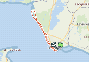
Trail Walking of 10.2 km to be discovered at Hauts-de-France, Somme, Le Crotoy. This trail is proposed by murph.

Description

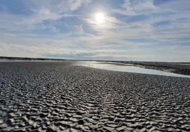
Vous aimerez : longer la mer et revenir caché derrière la dune !Découvrir près de la mer, un marais à la flore adaptée, animé par de nombreux oiseaux et les chevaux typiques de la baie : les Henson. Vous longerez la baie et mer si elle est haute sur toute la première partie du circuit jusqu'à l'entrée de la Réserve Naturelle de la Baie de Somme. Le retour se fait derrière les dunes sur le sentier du littoral, de beaux passages sous les pins puis dans les dunes pour terminer le long du marais dit de "La Bassée".

Elevation profile

Positioning

Country:
France
Region :
Hauts-de-France
Department/Province :
Somme
Municipality :
Le Crotoy
Location:
Unknown
Start:(UTM)
402111 ; 5563345 (31U) N.

Trails nearby

Trail Walking Saint-Valery-sur-Somme - Balade à Saint-Valéry-sur-Somme - Photo
Walking
GUIDE
Desrumaux

Walking

Easy
(4)
Saint-Valery-sur-Somme, Hauts-de-France, Somme, France
10.4 km | 12.2 km-effort
2h 41min
Yes
Trail Walking Le Crotoy - CDT80-3 - Photo
Walking

Walking

Medium
(2)
Le Crotoy, Hauts-de-France, Somme, France
6 km | 6.1 km-effort
1h 23min
Yes
Trail Walking Cayeux-sur-Mer - Le Hourdel V2 - Photo
Walking
tracegps

Walking

Difficult
(1)
Cayeux-sur-Mer, Hauts-de-France, Somme, France
8 km | 8.4 km-effort
2h 30min
Yes
Trail Walking Saint-Valery-sur-Somme - Balade à Saint-Valery sur Somme - Photo
Walking
tracegps

Walking

Medium
(3)
Saint-Valery-sur-Somme, Hauts-de-France, Somme, France
7.1 km | 8.6 km-effort
2h 19min
Yes
Trail Walking Favières - Circuit de Morlay - Photo
Walking
tracegps

Walking

Difficult
(1)
Favières, Hauts-de-France, Somme, France
12.4 km | 12.8 km-effort
4h 0min
Yes
Trail Walking Saint-Valery-sur-Somme - Traversée Baie de Somme 11/08/2021 - Photo
Walking
GUIDE
R@ph

Walking

Medium
Saint-Valery-sur-Somme, Hauts-de-France, Somme, France
8.5 km | 8.8 km-effort
2h 0min
No
Trail Walking Saint-Valery-sur-Somme - w-frankrijk-over-dijken-en-kwelders - Photo
Walking
gpstracks

Walking

Very easy
(2)
Saint-Valery-sur-Somme, Hauts-de-France, Somme, France
13.8 km | 14.9 km-effort
Unknown
Yes
Trail Mountain bike Saint-Valery-sur-Somme - Gravelot Baie de sommes - Photo
Mountain bike
Jeanlouisbray

Mountain bike

Easy
(1)
Saint-Valery-sur-Somme, Hauts-de-France, Somme, France
44 km | 47 km-effort
4h 56min
Yes
Trail Equestrian Le Crotoy - de la Maye vers marquenterre - Photo
Equestrian
ioudina

Equestrian

Very easy
(4)
Le Crotoy, Hauts-de-France, Somme, France
20 km | 21 km-effort
2h 43min
No


Close
My subscriptions