![](/images/other/stat-length.png)
![Trail Walking Feissons-sur-Salins - Feissons sur salins / Bois du sapey - Photo](https://media.geolcdn.com/t/1900/400/372d571c-3325-4051-9cd3-72995a78efc6.jpg&format=pjpeg&maxdim=2)
Feissons sur salins / Bois du sapey
ricou1964
User
![Length](/images/other/stat-length.png)
Length
15.2 km
![Max alt](https://static1.geolcdn.com/siteimages/upload/files/1508320355ic_sort_altitude_max_24dp.png)
Max alt
1736 m
![Uphill gradient](https://static1.geolcdn.com/siteimages/upload/files/1508320355ic_sort_den_pos_24dp.png)
Uphill gradient
550 m
![Km-Effort](/images/other/stat-length.png)
Km-Effort
23 km
![Min alt](https://static1.geolcdn.com/siteimages/upload/files/1508320355ic_sort_altitude_min_24dp.png)
Min alt
1262 m
![Downhill gradient](https://static1.geolcdn.com/siteimages/upload/files/1508320355ic_sort_den_neg_24dp.png)
Downhill gradient
553 m
![Boucle](https://static1.geolcdn.com/siteimages/upload/files/16400158638029165_repeat_loop_refresh_sync_direction_icon.png)
Boucle
Yes
Creation date :
2021-08-27 08:35:08.994
Updated on :
2021-08-28 15:31:07.083
![Walking](https://static1.geolcdn.com/sitytour/trail-icons/101.png)
4h02
Difficulty : Medium
![Scan this QR Code to open this trail in the SityTrail application](https://capi.geolives.com/qq0zvz2zws4bq2lad0pu/sitytour/trails/2914798/qr.png?size=200)
FREE GPS app for hiking
About
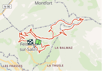
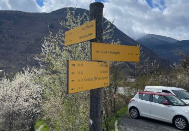
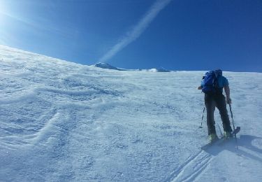
Trail Walking of 15.2 km to be discovered at Auvergne-Rhône-Alpes, Savoy, Feissons-sur-Salins. This trail is proposed by ricou1964.
Description
Balade principalement sur chemin forestier donc pas trop de difficultés. Quelques dénivelés un peu costauds mais de courte durée.
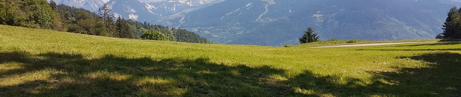
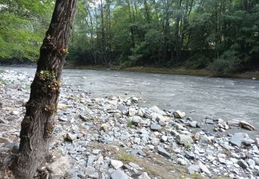
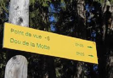
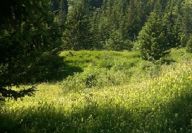
De jolis paysages
Positioning
Country:
France
Region :
Auvergne-Rhône-Alpes
Department/Province :
Savoy
Municipality :
Feissons-sur-Salins
Location:
Unknown
Start:(Dec)
Start:(UTM)
309530 ; 5038083 (32T) N.
Comments
Trails nearby
![Trail Walking Feissons-sur-Salins - Rando à Feissons - Photo](https://media.geolcdn.com/t/375/260/063eb2f4-6bf4-4b4a-a131-fc9697177278.jpg&format=jpg&maxdim=2)
![Walking Walking](https://static1.geolcdn.com/sitytour/trail-icons/101.png)
Rando à Feissons
Walking
Easy
Feissons-sur-Salins,
Auvergne-Rhône-Alpes,
Savoy,
France
![](/images/other/stat-length.png)
4.8 km | 7.5 km-effort
1h 33min
![](https://static1.geolcdn.com/siteimages/upload/files/16400158638029165_repeat_loop_refresh_sync_direction_icon.png)
Yes
![Trail Walking Feissons-sur-Salins - Croix de Feissons - Photo](https://media.geolcdn.com/t/375/260/ext.jpg?maxdim=2&url=https%3A%2F%2Fservices.sitytrail.com%2FGeolivesWS%2FDownloadMedia.ashx%3FTrailID%3D958597%26Media%3D3ded4b2c-a6b8-4dd9-b494-9ab426781ec1.jpg)
![Walking Walking](https://static1.geolcdn.com/sitytour/trail-icons/101.png)
Croix de Feissons
Walking
Easy
(1)
Feissons-sur-Salins,
Auvergne-Rhône-Alpes,
Savoy,
France
![](/images/other/stat-length.png)
4.6 km | 7.3 km-effort
1h 0min
![](https://static1.geolcdn.com/siteimages/upload/files/16400158638029165_repeat_loop_refresh_sync_direction_icon.png)
Yes
![Trail Walking Hautecour - Le sentier artistique de Hautecour - Photo](https://media.geolcdn.com/t/375/260/ext.jpg?maxdim=2&url=https%3A%2F%2Fstatic1.geolcdn.com%2Fsiteimages%2Fupload%2Ffiles%2F1553511878bg_sport_marche.png)
![Walking Walking](https://static1.geolcdn.com/sitytour/trail-icons/101.png)
Le sentier artistique de Hautecour
Walking
Easy
(1)
Hautecour,
Auvergne-Rhône-Alpes,
Savoy,
France
![](/images/other/stat-length.png)
4.2 km | 7.2 km-effort
1h 32min
![](https://static1.geolcdn.com/siteimages/upload/files/16400158638029165_repeat_loop_refresh_sync_direction_icon.png)
Yes
![Trail Mountain bike Les Allues - Col de la Lune depuis Le Villard - Photo](https://media.geolcdn.com/t/375/260/ext.jpg?maxdim=2&url=https%3A%2F%2Fstatic1.geolcdn.com%2Fsiteimages%2Fupload%2Ffiles%2F1524743154velo.jpg)
![Mountain bike Mountain bike](https://static1.geolcdn.com/sitytour/trail-icons/202.png)
Col de la Lune depuis Le Villard
Mountain bike
Difficult
(1)
Les Allues,
Auvergne-Rhône-Alpes,
Savoy,
France
![](/images/other/stat-length.png)
10.2 km | 18.1 km-effort
4h 0min
![](https://static1.geolcdn.com/siteimages/upload/files/16400158638029165_repeat_loop_refresh_sync_direction_icon.png)
Yes
![Trail Walking Brides-les-Bains - Brides les Bains - Photo](https://media.geolcdn.com/t/375/260/d966be4d-7a5e-462b-885b-72f95b4b7992.jpg&format=jpg&maxdim=2)
![Walking Walking](https://static1.geolcdn.com/sitytour/trail-icons/101.png)
Brides les Bains
Walking
Medium
Brides-les-Bains,
Auvergne-Rhône-Alpes,
Savoy,
France
![](/images/other/stat-length.png)
5.3 km | 8.4 km-effort
1h 25min
![](https://static1.geolcdn.com/siteimages/upload/files/16400158638029165_repeat_loop_refresh_sync_direction_icon.png)
Yes
![Trail Walking Grand-Aigueblanche - Cascade du Morel-20-07-22 - Photo](https://media.geolcdn.com/t/375/260/f72b1eaf-d1a3-4853-ba57-b26ebe92f90e.jpg&format=jpg&maxdim=2)
![Walking Walking](https://static1.geolcdn.com/sitytour/trail-icons/101.png)
Cascade du Morel-20-07-22
Walking
Medium
Grand-Aigueblanche,
Auvergne-Rhône-Alpes,
Savoy,
France
![](/images/other/stat-length.png)
12.1 km | 15.9 km-effort
2h 38min
![](https://static1.geolcdn.com/siteimages/upload/files/16400158638029165_repeat_loop_refresh_sync_direction_icon.png)
Yes
![On foot On foot](https://static1.geolcdn.com/sitytour/trail-icons/100.png)
Le Dou de la Motte en boucle depuis le Refuge de la Traye
On foot
Very easy
Les Allues,
Auvergne-Rhône-Alpes,
Savoy,
France
![](/images/other/stat-length.png)
4.5 km | 7.6 km-effort
1h 30min
![](https://static1.geolcdn.com/siteimages/upload/files/16400158638029165_repeat_loop_refresh_sync_direction_icon.png)
Yes
![Trail Walking Les Allues - les Allues à Combe Cure - Photo](https://media.geolcdn.com/t/375/260/ext.jpg?maxdim=2&url=https%3A%2F%2Fservices.sitytrail.com%2FGeolivesWS%2FDownloadMedia.ashx%3FTrailID%3D596392%26Media%3Dfix__20160711110233.jpg)
![Walking Walking](https://static1.geolcdn.com/sitytour/trail-icons/101.png)
les Allues à Combe Cure
Walking
Medium
Les Allues,
Auvergne-Rhône-Alpes,
Savoy,
France
![](/images/other/stat-length.png)
9.7 km | 17.8 km-effort
4h 4min
![](https://static1.geolcdn.com/siteimages/upload/files/16400158638029165_repeat_loop_refresh_sync_direction_icon.png)
Yes
![Trail Other activity Notre-Dame-du-Pré - mont jovet par lez mont des archets - Photo](https://media.geolcdn.com/t/375/260/ext.jpg?maxdim=2&url=https%3A%2F%2Fservices.sitytrail.com%2FGeolivesWS%2FDownloadMedia.ashx%3FTrailID%3D563684%26Media%3Dfix__20160504091838.jpg)
![Other activity Other activity](https://static1.geolcdn.com/sitytour/trail-icons/900.png)
mont jovet par lez mont des archets
Other activity
Very easy
Notre-Dame-du-Pré,
Auvergne-Rhône-Alpes,
Savoy,
France
![](/images/other/stat-length.png)
6.5 km | 15.4 km-effort
2h 53min
![](https://static1.geolcdn.com/siteimages/upload/files/16400158638029165_repeat_loop_refresh_sync_direction_icon.png)
No