![](/images/other/stat-length.png)
![Trail Walking Gigny - Gigny Andelot - Photo](https://media.geolcdn.com/t/1900/400/15180df1-3b9d-4a33-a8c9-c04406d679c2.jpg&format=pjpeg&maxdim=2)
Gigny Andelot
dominiq
User
![Length](/images/other/stat-length.png)
Length
18.7 km
![Max alt](https://static1.geolcdn.com/siteimages/upload/files/1508320355ic_sort_altitude_max_24dp.png)
Max alt
560 m
![Uphill gradient](https://static1.geolcdn.com/siteimages/upload/files/1508320355ic_sort_den_pos_24dp.png)
Uphill gradient
445 m
![Km-Effort](/images/other/stat-length.png)
Km-Effort
25 km
![Min alt](https://static1.geolcdn.com/siteimages/upload/files/1508320355ic_sort_altitude_min_24dp.png)
Min alt
363 m
![Downhill gradient](https://static1.geolcdn.com/siteimages/upload/files/1508320355ic_sort_den_neg_24dp.png)
Downhill gradient
446 m
![Boucle](https://static1.geolcdn.com/siteimages/upload/files/16400158638029165_repeat_loop_refresh_sync_direction_icon.png)
Boucle
Yes
Creation date :
2021-08-26 06:49:36.0
Updated on :
2021-08-26 18:33:43.8
![Walking](https://static1.geolcdn.com/sitytour/trail-icons/101.png)
5h32
Difficulty : Easy
![Scan this QR Code to open this trail in the SityTrail application](https://capi.geolives.com/qq0zvz2zws4bq2lad0pu/sitytour/trails/2913589/qr.png?size=200)
FREE GPS app for hiking
About
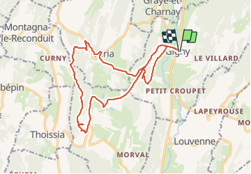
Trail Walking of 18.7 km to be discovered at Bourgogne-Franche-Comté, Jura, Gigny. This trail is proposed by dominiq.
Description
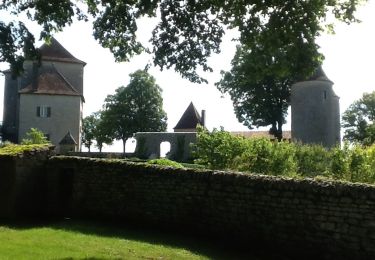
Très belle randonnée qui part de Gigny pour aller au château d'Andelot en Montagne avec retour par Vériat.
Petit tour au belvédère d'Andelot pour la vue sur la vallée du Suran.
Positioning
Country:
France
Region :
Bourgogne-Franche-Comté
Department/Province :
Jura
Municipality :
Gigny
Location:
Unknown
Start:(Dec)
Start:(UTM)
689021 ; 5147199 (31T) N.
Comments
Trails nearby
![Trail Horseback riding Dramelay - Jour 2 Rando Petite Écurie - Photo](https://media.geolcdn.com/t/375/260/0ed65ef1-41b4-4ec6-a37d-69f117609a02.jpg&format=jpg&maxdim=2)
![Horseback riding Horseback riding](https://static1.geolcdn.com/sitytour/trail-icons/301.png)
Jour 2 Rando Petite Écurie
Horseback riding
Easy
Dramelay,
Bourgogne-Franche-Comté,
Jura,
France
![](/images/other/stat-length.png)
23 km | 29 km-effort
5h 34min
![](https://static1.geolcdn.com/siteimages/upload/files/16400158638029165_repeat_loop_refresh_sync_direction_icon.png)
No
![Trail Walking Marigna-sur-Valouse - Marigna-Monnetay - Photo](https://media.geolcdn.com/t/375/260/ext.jpg?maxdim=2&url=https%3A%2F%2Fservices.sitytrail.com%2FGeolivesWS%2FDownloadMedia.ashx%3FTrailID%3D939235%26Media%3Dfix__20180408172638.jpg)
![Walking Walking](https://static1.geolcdn.com/sitytour/trail-icons/101.png)
Marigna-Monnetay
Walking
Very easy
Marigna-sur-Valouse,
Bourgogne-Franche-Comté,
Jura,
France
![](/images/other/stat-length.png)
6.5 km | 9.5 km-effort
2h 1min
![](https://static1.geolcdn.com/siteimages/upload/files/16400158638029165_repeat_loop_refresh_sync_direction_icon.png)
No
![Trail Walking Andelot-Morval - Andelot-Morval 20160620 - Photo](https://media.geolcdn.com/t/375/260/ext.jpg?maxdim=2&url=https%3A%2F%2Fservices.sitytrail.com%2FGeolivesWS%2FDownloadMedia.ashx%3FTrailID%3D586950%26Media%3D20160620103846.jpg)
![Walking Walking](https://static1.geolcdn.com/sitytour/trail-icons/101.png)
Andelot-Morval 20160620
Walking
Easy
Andelot-Morval,
Bourgogne-Franche-Comté,
Jura,
France
![](/images/other/stat-length.png)
11.5 km | 15.3 km-effort
3h 17min
![](https://static1.geolcdn.com/siteimages/upload/files/16400158638029165_repeat_loop_refresh_sync_direction_icon.png)
Yes
![Trail Walking Graye-et-Charnay - Graye en sous-bois - Photo](https://media.geolcdn.com/t/375/260/ext.jpg?maxdim=2&url=https%3A%2F%2Fstatic1.geolcdn.com%2Fsiteimages%2Fupload%2Ffiles%2F1553511878bg_sport_marche.png)
![Walking Walking](https://static1.geolcdn.com/sitytour/trail-icons/101.png)
Graye en sous-bois
Walking
Very easy
Graye-et-Charnay,
Bourgogne-Franche-Comté,
Jura,
France
![](/images/other/stat-length.png)
6.3 km | 8.3 km-effort
1h 42min
![](https://static1.geolcdn.com/siteimages/upload/files/16400158638029165_repeat_loop_refresh_sync_direction_icon.png)
Yes
![Trail Walking Gigny - gigny réel - Photo](https://media.geolcdn.com/t/375/260/ext.jpg?maxdim=2&url=https%3A%2F%2Fstatic1.geolcdn.com%2Fsiteimages%2Fupload%2Ffiles%2F1553511878bg_sport_marche.png)
![Walking Walking](https://static1.geolcdn.com/sitytour/trail-icons/101.png)
gigny réel
Walking
Very difficult
Gigny,
Bourgogne-Franche-Comté,
Jura,
France
![](/images/other/stat-length.png)
18.1 km | 24 km-effort
5h 35min
![](https://static1.geolcdn.com/siteimages/upload/files/16400158638029165_repeat_loop_refresh_sync_direction_icon.png)
Yes
![Trail Walking Gigny - gigny - Photo](https://media.geolcdn.com/t/375/260/ext.jpg?maxdim=2&url=https%3A%2F%2Fstatic1.geolcdn.com%2Fsiteimages%2Fupload%2Ffiles%2F1553511878bg_sport_marche.png)
![Walking Walking](https://static1.geolcdn.com/sitytour/trail-icons/101.png)
gigny
Walking
Medium
Gigny,
Bourgogne-Franche-Comté,
Jura,
France
![](/images/other/stat-length.png)
18.4 km | 24 km-effort
6h 34min
![](https://static1.geolcdn.com/siteimages/upload/files/16400158638029165_repeat_loop_refresh_sync_direction_icon.png)
Yes
![Trail Walking Andelot-Morval - Angelot les St Amour-Nantey - Photo](https://media.geolcdn.com/t/375/260/ext.jpg?maxdim=2&url=https%3A%2F%2Fstatic1.geolcdn.com%2Fsiteimages%2Fupload%2Ffiles%2F1553511878bg_sport_marche.png)
![Walking Walking](https://static1.geolcdn.com/sitytour/trail-icons/101.png)
Angelot les St Amour-Nantey
Walking
Easy
Andelot-Morval,
Bourgogne-Franche-Comté,
Jura,
France
![](/images/other/stat-length.png)
12.7 km | 17.1 km-effort
3h 46min
![](https://static1.geolcdn.com/siteimages/upload/files/16400158638029165_repeat_loop_refresh_sync_direction_icon.png)
Yes
![Trail Walking Val-d'Épy - Val d'Epy départ - Photo](https://media.geolcdn.com/t/375/260/7c7a18d9-23e7-4bb1-b0ee-17c0ae3c3c19.jpg&format=jpg&maxdim=2)
![Walking Walking](https://static1.geolcdn.com/sitytour/trail-icons/101.png)
Val d'Epy départ
Walking
Easy
Val-d'Épy,
Bourgogne-Franche-Comté,
Jura,
France
![](/images/other/stat-length.png)
14.2 km | 18.6 km-effort
3h 56min
![](https://static1.geolcdn.com/siteimages/upload/files/16400158638029165_repeat_loop_refresh_sync_direction_icon.png)
Yes
![Trail Walking Véria - veria - Photo](https://media.geolcdn.com/t/375/260/ext.jpg?maxdim=2&url=https%3A%2F%2Fstatic1.geolcdn.com%2Fsiteimages%2Fupload%2Ffiles%2F1553511878bg_sport_marche.png)
![Walking Walking](https://static1.geolcdn.com/sitytour/trail-icons/101.png)
veria
Walking
Difficult
Véria,
Bourgogne-Franche-Comté,
Jura,
France
![](/images/other/stat-length.png)
22 km | 28 km-effort
4h 34min
![](https://static1.geolcdn.com/siteimages/upload/files/16400158638029165_repeat_loop_refresh_sync_direction_icon.png)
No