Trail Horseback riding Villandry - Location history from 2021-08-21 to 2021-08-21 - Photo

Location history from 2021-08-21 to 2021-08-21

 mattr91
mattr91

User

© OpenStreetMap contributors
Length
Length
16.7 km
Max alt
Max alt
99 m
Uphill gradient
Uphill gradient
147 m
Km-Effort
Km-Effort  
18.6 km
Min alt
Min alt
39 m
Downhill gradient
Downhill gradient
144 m
Boucle
Boucle
Yes
Creation date :
2021-08-22 16:54:01.942
Updated on :
2021-08-23 07:23:30.548

(1 Reviews)

Horseback riding
Horseback riding
2h27
Difficulty : Easy
Coupling
Coupling
3h00
Difficulty : Easy

Scan this QR Code to open this trail in the SityTrail application

FREE GPS app for hiking

Logo SityTrail SityTrail

IGN / Geographical institutes

Download SityTrail from the App Store Download SityTrail from Google Play

Logo SityTrail SityTrail World

The world is yours!

Download SityTrail from the App Store Download SityTrail from Google Play Download SityTrail on Huawei AppGallery

About

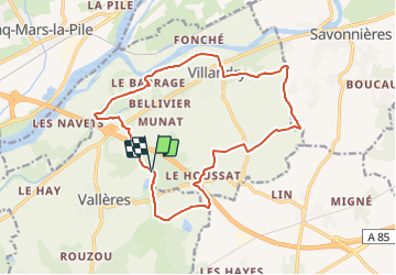
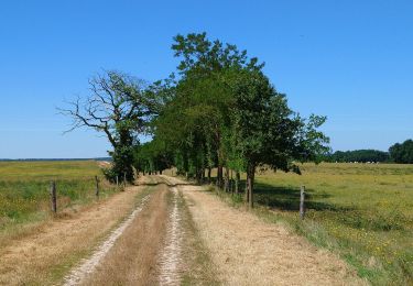
Trail Horseback riding of 16.7 km to be discovered at Centre-Loire Valley, Indre-et-Loire, Villandry. This trail is proposed by mattr91.

Elevation profile

Positioning

Country:
France
Region :
Centre-Loire Valley
Department/Province :
Indre-et-Loire
Municipality :
Villandry
Location:
Unknown
Start:(UTM)
310334 ; 5243566 (31T) N.

Comments

Please log in to post a review or rate the element


Top. Pas mal de route mais super sympa


Trails nearby

Trail Walking Savonnières - Saveniére - Photo
Walking
jouhan

Walking

Medium
Savonnières, Centre-Loire Valley, Indre-et-Loire, France
5.8 km | 6.9 km-effort
1h 38min
No
Trail On foot Villandry - Villandry - Photo
On foot
fustier

On foot

Medium
(1)
Villandry, Centre-Loire Valley, Indre-et-Loire, France
22 km | 24 km-effort
Unknown
Yes
Trail Walking Villandry - villandry - Photo
Walking
dporcher

Walking

Very easy
Villandry, Centre-Loire Valley, Indre-et-Loire, France
11.3 km | 12.7 km-effort
2h 18min
Yes
Trail Walking Villandry - A L'Orée Du Chateau De Villandry - Photo
Walking
Patakk

Walking

Easy
Villandry, Centre-Loire Valley, Indre-et-Loire, France
11.6 km | 13 km-effort
2h 15min
Yes
Trail Equestrian Villandry - Autour de Vallères - Photo
Equestrian
tracegps

Equestrian

Medium
Villandry, Centre-Loire Valley, Indre-et-Loire, France
9.3 km | 10.8 km-effort
2h 30min
Yes
Trail Equestrian Villandry - Château de Villandry - Photo
Equestrian
tracegps

Equestrian

Medium
Villandry, Centre-Loire Valley, Indre-et-Loire, France
12.8 km | 14.6 km-effort
3h 0min
Yes
Trail Equestrian Villandry - Boucle à Vallères - Photo
Equestrian
tracegps

Equestrian

Medium
Villandry, Centre-Loire Valley, Indre-et-Loire, France
6.5 km | 7.6 km-effort
1h 30min
Yes
Trail Equestrian Villandry - Les bords de Loire - Villandry - Photo
Equestrian
tracegps

Equestrian

Medium
Villandry, Centre-Loire Valley, Indre-et-Loire, France
12.3 km | 14 km-effort
3h 0min
Yes
Trail Mountain bike Cinq-Mars-la-Pile - Cinq Mars la Pile, Maziéres de Touraine, Langeais - Photo
Mountain bike
tracegps

Mountain bike

Difficult
Cinq-Mars-la-Pile, Centre-Loire Valley, Indre-et-Loire, France
26 km | 31 km-effort
1h 45min
Yes


Close
My subscriptions