Trail Walking Hauteluce - AnyConv.com__montagne_d_outray_-pointe_sud - Photo

AnyConv.com__montagne_d_outray_-pointe_sud

 jpb83
jpb83

User

© OpenStreetMap contributors
Length
Length
4.6 km
Max alt
Max alt
2318 m
Uphill gradient
Uphill gradient
699 m
Km-Effort
Km-Effort  
12.3 km
Min alt
Min alt
1626 m
Downhill gradient
Downhill gradient
214 m
Boucle
Boucle
No
Creation date :
2021-08-18 20:01:46.435
Updated on :
2021-08-18 20:04:12.569

(0 Reviews)

Walking
Walking
2h48
Difficulty : Medium

Scan this QR Code to open this trail in the SityTrail application

FREE GPS app for hiking

Logo SityTrail SityTrail

IGN / Geographical institutes

Download SityTrail from the App Store Download SityTrail from Google Play

Logo SityTrail SityTrail World

The world is yours!

Download SityTrail from the App Store Download SityTrail from Google Play Download SityTrail on Huawei AppGallery

About

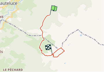
Trail Walking of 4.6 km to be discovered at Auvergne-Rhône-Alpes, Savoy, Hauteluce. This trail is proposed by jpb83.

Description

Point culminant de la Montagne d'Outray. la Pointe Sud est "assez facile" d'accès par cet itinéraire, elle domine Beaufort, Hauteluce, Roselend et vous offrira un magnifique panorama..

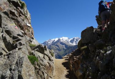
Pas de réelles difficultés techniques sur cette rando mais dernière montée raide sur une sente et quelques passages aériens sur la crête vers le sommet.

Montée

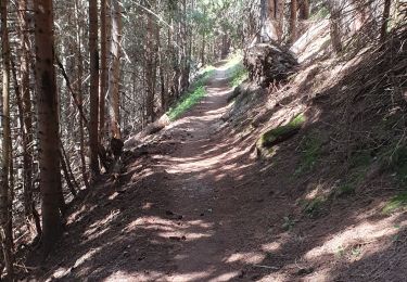
Au parking du Sapin on trouve un panneau (1618m) suivre le Pas d’Outray par la piste forestière (sud-ouest).

La piste se termine au lieu-dit la Journée (1693m), panneau, suivre le Pas d’Outray par le sentier.

Plus loin on croise un autre panneau Outray (1820m), toujours suivre Pas d’Outray.

Arrivé au Pas d’Outray (2182m), panneau, suivre Col du Sallestet et à l’entrée de l’alpage d’Outray prendre une petite sente à gauche.

Cette sente devient un sentier plus marqué en passant au dessus du petit chalet-abri des chasseurs (abri des trois moineaux) et se dirige à flanc sous la Montagne d’Outray.

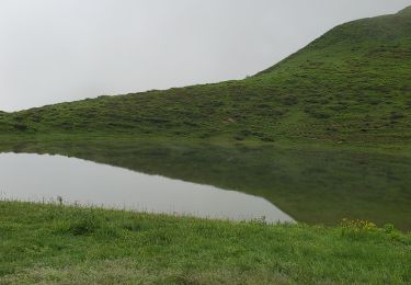
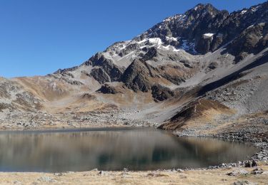
On passe vers une petite gouille (2200m) avant de poursuivre la montée au pied de l’arête sud-est de la Pointe Sud.

Une petite sente permet d’atteindre la crête que l’on longera (sud-ouest) jusqu’à la pointe sommitale de la Montagne d’Outray (2346m). Quelques passages aériens à négocier prudemment.

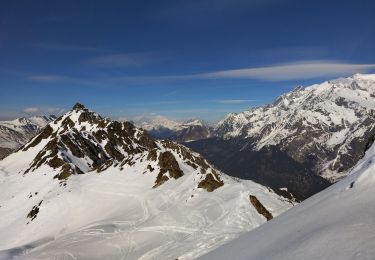
Par grand beau temps la vue porte loin sur cette pointe, vers le Mont Blanc, Vanoise, Ecrins, Meije, Belledonne, Bauges, Bornes, Aravis, Platé/Fiz, Giffre, Aiguilles Rouges....et une grande partie Beaufortain.
Retour par le même itinéraire

Elevation profile

Points of interest

Point of interest Hauteluce - Départ - Photo
jpb83
HAUTELUCE 
Point of interest Beaufort - Le Pas d'Outray - Photo
jpb83
BEAUFORT 
Point of interest Hauteluce - Pointe Sud - Photo
jpb83
HAUTELUCE 

Positioning

Country:
France
Region :
Auvergne-Rhône-Alpes
Department/Province :
Savoy
Municipality :
Hauteluce
Location:
Unknown
Start:(UTM)
314176 ; 5068585 (32T) N.

Trails nearby

Trail Touring skiing Hauteluce - Col de cicle en passant par un couloir et col de la fenêtre  - Photo
Touring skiing
GUIDE
nadd73

Touring skiing

Medium
Hauteluce, Auvergne-Rhône-Alpes, Savoy, France
19 km | 33 km-effort
5h 33min
Yes
Trail Touring skiing Hauteluce - Rocher des enclaves et montagne d'outray - Photo
Touring skiing
GUIDE
nadd73

Touring skiing

Medium
Hauteluce, Auvergne-Rhône-Alpes, Savoy, France
14 km | 33 km-effort
6h 4min
Yes
Trail Walking Hauteluce - SityTrail - col de la fenêtre  - Photo
Walking
bob2023

Walking

Medium
(1)
Hauteluce, Auvergne-Rhône-Alpes, Savoy, France
7.8 km | 12.4 km-effort
2h 34min
Yes
Trail Walking Hauteluce - Hauteluce - Photo
Walking
albertville

Walking

Very easy
(2)
Hauteluce, Auvergne-Rhône-Alpes, Savoy, France
4.1 km | 7.4 km-effort
1h 54min
Yes
Trail Walking Hauteluce - Mont Clocher - Photo
Walking
aglagla5

Walking

Very easy
(2)
Hauteluce, Auvergne-Rhône-Alpes, Savoy, France
7.3 km | 10.4 km-effort
1h 47min
Yes
Trail Mountain bike Hauteluce - tour lac girote - Photo
Mountain bike
tintin73

Mountain bike

Medium
Hauteluce, Auvergne-Rhône-Alpes, Savoy, France
21 km | 36 km-effort
2h 20min
Yes
Trail Walking Hauteluce - lacs jovet col de joly 1015m 20kms  - Photo
Walking
GUIDE
Danielba

Walking

Medium
Hauteluce, Auvergne-Rhône-Alpes, Savoy, France
18.7 km | 31 km-effort
8h 11min
Yes
Trail Walking Hauteluce - val d arly mont clocher - Photo
Walking
anniediot

Walking

Very easy
(1)
Hauteluce, Auvergne-Rhône-Alpes, Savoy, France
9.6 km | 13.4 km-effort
3h 35min
Yes
Trail Walking Les Contamines-Montjoie - lacs Jovet par le col de la fenêtre  - Photo
Walking
fafa74

Walking

Difficult
Les Contamines-Montjoie, Auvergne-Rhône-Alpes, Upper Savoy, France
16.9 km | 30 km-effort
5h 32min
Yes


Close
My subscriptions