Trail Walking Sainte-Olive - Ste olive genevieve - Photo
 maclobar
maclobar

User

© OpenStreetMap contributors
Length
Length
14.4 km
Max alt
Max alt
299 m
Uphill gradient
Uphill gradient
79 m
Km-Effort
Km-Effort  
15.5 km
Min alt
Min alt
268 m
Downhill gradient
Downhill gradient
79 m
Boucle
Boucle
Yes
Creation date :
2021-08-18 07:56:22.471
Updated on :
2021-08-18 15:20:56.437

(0 Reviews)

Walking
Walking
4h14
Difficulty : Difficult

Scan this QR Code to open this trail in the SityTrail application

FREE GPS app for hiking

Logo SityTrail SityTrail

IGN / Geographical institutes

Download SityTrail from the App Store Download SityTrail from Google Play

Logo SityTrail SityTrail World

The world is yours!

Download SityTrail from the App Store Download SityTrail from Google Play Download SityTrail on Huawei AppGallery

About

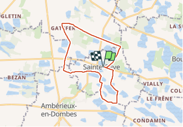
Trail Walking of 14.4 km to be discovered at Auvergne-Rhône-Alpes, Ain, Sainte-Olive. This trail is proposed by maclobar.

Elevation profile

Positioning

Country:
France
Region :
Auvergne-Rhône-Alpes
Department/Province :
Ain
Municipality :
Sainte-Olive
Location:
Unknown
Start:(UTM)
649624 ; 5097953 (31T) N.

Comments

Please log in to post a review or rate the element


agréable randonnée en pleine campagne.


Trails nearby

Trail Motor Sainte-Olive - journée solex du 26 juin 2024 - Photo
Motor
michelrongier

Motor

Very easy
Sainte-Olive, Auvergne-Rhône-Alpes, Ain, France
66 km | 71 km-effort
Unknown
Yes
Trail Horseback riding Saint-Trivier-sur-Moignans - Poneys Aventure Ferme Passion - Photo
Horseback riding
Ferme-Passion

Horseback riding

Easy
Saint-Trivier-sur-Moignans, Auvergne-Rhône-Alpes, Ain, France
17.3 km | 19.2 km-effort
2h 31min
No
Trail Walking Ambérieux-en-Dombes - Amberieux en Dombes - Photo
Walking
Thomasdanielle

Walking

Easy
Ambérieux-en-Dombes, Auvergne-Rhône-Alpes, Ain, France
18.5 km | 20 km-effort
4h 55min
Yes
Trail Walking Sainte-Olive - 01 - SAINTE-OLIVE - Photo
Walking
AndreLACOMBE

Walking

Very easy
Sainte-Olive, Auvergne-Rhône-Alpes, Ain, France
6.6 km | 7.1 km-effort
2h 29min
Yes
Trail Walking Bouligneux - Bouligneux-Etang de la petite Bozonnière-Ain - Photo
Walking
ThierryJ01

Walking

Medium
Bouligneux, Auvergne-Rhône-Alpes, Ain, France
7 km | 7.6 km-effort
1h 43min
Yes
Trail Walking Sainte-Olive - Sainte Olive-Etang de Chardonnet-Ain - Photo
Walking
ThierryJ01

Walking

Medium
Sainte-Olive, Auvergne-Rhône-Alpes, Ain, France
6.5 km | 7 km-effort
1h 35min
Yes
Trail Cycle Ambérieux-en-Dombes - Amberieux-en-Dombes - Photo
Cycle
doclocjl

Cycle

Very easy
Ambérieux-en-Dombes, Auvergne-Rhône-Alpes, Ain, France
41 km | 45 km-effort
3h 44min
Yes
Trail Walking Bouligneux - Les étangs de Bouligneux - Photo
Walking
florent43

Walking

Easy
(3)
Bouligneux, Auvergne-Rhône-Alpes, Ain, France
7.2 km | 7.8 km-effort
4h 0min
Yes
Trail Motor Sainte-Olive - Journée Solex du 26 Juin rectif 2 - Photo
Motor
BGO

Motor

Very easy
Sainte-Olive, Auvergne-Rhône-Alpes, Ain, France
68 km | 74 km-effort
Unknown
Yes


Close
My subscriptions