Trail Mountain bike Saint-Brice-Courcelles - vtt  - Photo
 dencol
dencol

User

© OpenStreetMap contributors
Length
Length
19.7 km
Max alt
Max alt
137 m
Uphill gradient
Uphill gradient
166 m
Km-Effort
Km-Effort  
22 km
Min alt
Min alt
67 m
Downhill gradient
Downhill gradient
160 m
Boucle
Boucle
No
Creation date :
2021-08-15 08:23:17.343
Updated on :
2021-08-15 09:42:12.988

(0 Reviews)

Mountain bike
Mountain bike
1h18
Difficulty : Medium

Scan this QR Code to open this trail in the SityTrail application

FREE GPS app for hiking

Logo SityTrail SityTrail

IGN / Geographical institutes

Download SityTrail from the App Store Download SityTrail from Google Play

Logo SityTrail SityTrail World

The world is yours!

Download SityTrail from the App Store Download SityTrail from Google Play Download SityTrail on Huawei AppGallery

About

Trail Mountain bike of 19.7 km to be discovered at Grand Est, Marne, Saint-Brice-Courcelles. This trail is proposed by dencol.

Description

vtt reims

Elevation profile

Positioning

Country:
France
Region :
Grand Est
Department/Province :
Marne
Municipality :
Saint-Brice-Courcelles
Location:
Unknown
Start:(UTM)
572293 ; 5459217 (31U) N.

Trails nearby

Trail Walking Chenay - chenay  - Photo
Walking
0674628622

Walking

Difficult
(3)
Chenay, Grand Est, Marne, France
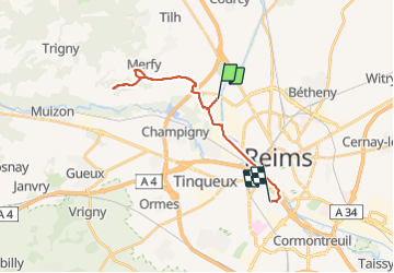
15.9 km | 19.4 km-effort
3h 42min
Yes
Trail Hybrid bike Reims - Balade à vélo au cœur de la capitale Champenoise - Photo
Hybrid bike
Bntg

Hybrid bike

Very easy
Reims, Grand Est, Marne, France
15.2 km | 16.8 km-effort
Unknown
Yes
Trail Walking Merfy - Merfy - Reims  - Photo
Walking
GUIDE
VANDERPUTTENMi

Walking

Very easy
Merfy, Grand Est, Marne, France
11 km | 11.9 km-effort
2h 38min
No
Trail Cycle Reims - Reims - Epernay (Montagne de Reims) - Photo
Cycle
pinkzebra

Cycle

Medium
Reims, Grand Est, Marne, France
47 km | 53 km-effort
3h 5min
No
Trail Walking Reims - La Via Francigena - Reims - Châlons en Champagne - Photo
Walking
tracegps

Walking

Medium
Reims, Grand Est, Marne, France
61 km | 69 km-effort
12h 30min
No
Trail Walking Reims - Chemin de Compostelle, Voie de Vézelay GR654® De Reims à Verzy - Photo
Walking
tracegps

Walking

Difficult
(2)
Reims, Grand Est, Marne, France
25 km | 28 km-effort
5h 0min
No
Trail sport Courcy - Étape 1 Courcy jusqu’à Conde s Marne - Photo
sport
Roydger

sport

Very easy
(1)
Courcy, Grand Est, Marne, France
52 km | 58 km-effort
Unknown
No
Trail Walking Reims - Reims balade historique - Photo
Walking
GUIDE
chessyca

Walking

Medium
Reims, Grand Est, Marne, France
9.1 km | 9.8 km-effort
2h 42min
No
Trail Hybrid bike Reims - Compostelle 4 Reims a Bailly le franc  - Photo
Hybrid bike
Roydger

Hybrid bike

Very difficult
Reims, Grand Est, Marne, France
151 km | 167 km-effort
Unknown
No


Close
My subscriptions