Trail Walking Saint-Mury-Monteymond - Boucle :  Lac du crozet depuis parking de la Pra - Photo

Boucle : Lac du crozet depuis parking de la Pra

 manumax
manumax

User

© OpenStreetMap contributors
Length
Length
12.4 km
Max alt
Max alt
2368 m
Uphill gradient
Uphill gradient
982 m
Km-Effort
Km-Effort  
25 km
Min alt
Min alt
1433 m
Downhill gradient
Downhill gradient
983 m
Boucle
Boucle
Yes
Creation date :
2021-08-12 20:16:57.062
Updated on :
2021-08-23 20:22:05.407

(0 Reviews)

Walking
Walking
5h47
Difficulty : Very difficult

Scan this QR Code to open this trail in the SityTrail application

FREE GPS app for hiking

Logo SityTrail SityTrail

IGN / Geographical institutes

Download SityTrail from the App Store Download SityTrail from Google Play

Logo SityTrail SityTrail World

The world is yours!

Download SityTrail from the App Store Download SityTrail from Google Play Download SityTrail on Huawei AppGallery

About

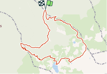
Trail Walking of 12.4 km to be discovered at Auvergne-Rhône-Alpes, Isère, Saint-Mury-Monteymond. This trail is proposed by manumax.

Description

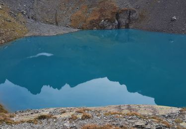
Randonnée à faire, une variante de la boucle du lac du crozet

Elevation profile

Positioning

Country:
France
Region :
Auvergne-Rhône-Alpes
Department/Province :
Isère
Municipality :
Saint-Mury-Monteymond
Location:
Unknown
Start:(UTM)
730155 ; 5008660 (31T) N.

Trails nearby

Trail On foot La Combe-de-Lancey - Chemin de Découverte (boucle Basse) - Photo
On foot
PRO

On foot

Easy
La Combe-de-Lancey, Auvergne-Rhône-Alpes, Isère, France
3.5 km | 5.1 km-effort
1h 9min
Yes
Trail On foot La Combe-de-Lancey - Chemin de Découverte (boucle Haute) - Photo
On foot
PRO

On foot

Easy
La Combe-de-Lancey, Auvergne-Rhône-Alpes, Isère, France
3.5 km | 5.4 km-effort
1h 13min
Yes
Trail On foot Saint-Jean-le-Vieux - La Tour de Revel (par le Mollard) - Photo
On foot
PRO

On foot

Easy
Saint-Jean-le-Vieux, Auvergne-Rhône-Alpes, Isère, France
7.9 km | 13.4 km-effort
3h 2min
No
Trail Touring skiing Laval-en-Belledonne - col du Rafour et couloir ouest de la montagne de Barlet - Photo
Touring skiing
GUIDE
nadd73

Touring skiing

Difficult
Laval-en-Belledonne, Auvergne-Rhône-Alpes, Isère, France
10.9 km | 26 km-effort
6h 29min
No
Trail Walking Saint-Martin-d'Uriage - Les Seiglières. Circuit des Gardes n°9 raccourci à 8 km - Photo
Walking
patjobou

Walking

Medium
Saint-Martin-d'Uriage, Auvergne-Rhône-Alpes, Isère, France
8.1 km | 12.6 km-effort
2h 51min
Yes
Trail Walking La Combe-de-Lancey - Col du Pré du Molard - Photo
Walking
flip38

Walking

Difficult
La Combe-de-Lancey, Auvergne-Rhône-Alpes, Isère, France
17.8 km | 33 km-effort
5h 19min
Yes
Trail Walking Saint-Mury-Monteymond - Lac Blanc au pied de Belledonne - Photo
Walking
GuyVachet

Walking

Very difficult
Saint-Mury-Monteymond, Auvergne-Rhône-Alpes, Isère, France
12.2 km | 26 km-effort
5h 49min
Yes
Trail Walking Revel - Montagne 15/08/2023 - Photo
Walking
cater38

Walking

Difficult
Revel, Auvergne-Rhône-Alpes, Isère, France
16.2 km | 32 km-effort
6h 36min
Yes
Trail Walking Saint-Mury-Monteymond - Col et Pointe de la Sitre - Photo
Walking
ranchoup

Walking

Very difficult
Saint-Mury-Monteymond, Auvergne-Rhône-Alpes, Isère, France
11.2 km | 23 km-effort
5h 14min
Yes


Close
My subscriptions