![](/images/other/stat-length.png)
![Trail Mountain bike Castries - Autour de Castries - 4152 - UtagawaVTT.com - Photo](https://media.geolcdn.com/t/1900/400/ext.pjpeg?maxdim=2&url=https%3A%2F%2Fstatic1.geolcdn.com%2Fsiteimages%2Fupload%2Ffiles%2F1524743154velo.jpg)
Autour de Castries - 4152 - UtagawaVTT.com
touareg3400
User
![Length](/images/other/stat-length.png)
![Max alt](https://static1.geolcdn.com/siteimages/upload/files/1508320355ic_sort_altitude_max_24dp.png)
![Uphill gradient](https://static1.geolcdn.com/siteimages/upload/files/1508320355ic_sort_den_pos_24dp.png)
![Km-Effort](/images/other/stat-length.png)
![Min alt](https://static1.geolcdn.com/siteimages/upload/files/1508320355ic_sort_altitude_min_24dp.png)
![Downhill gradient](https://static1.geolcdn.com/siteimages/upload/files/1508320355ic_sort_den_neg_24dp.png)
![Boucle](https://static1.geolcdn.com/siteimages/upload/files/16400158638029165_repeat_loop_refresh_sync_direction_icon.png)
![Mountain bike](https://static1.geolcdn.com/sitytour/trail-icons/202.png)
--
Difficulty : Unknown
![Scan this QR Code to open this trail in the SityTrail application](https://capi.geolives.com/qq0zvz2zws4bq2lad0pu/sitytour/trails/2895998/qr.png?size=200)
FREE GPS app for hiking
About
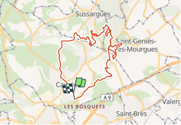
Trail Mountain bike of 22 km to be discovered at Occitania, Hérault, Castries. This trail is proposed by touareg3400.
Description
https://www.utagawavtt.com/randonnee-vtt-gps/Autour-de-Castries-4152
Itinéraire
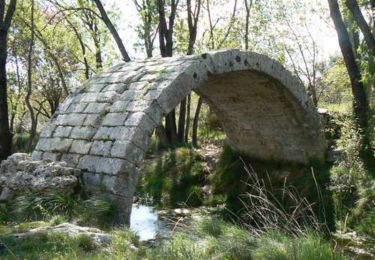
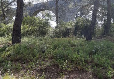
Itinéraire permettant d'emmener des gens dans du technique sans les dégoûter et de découvrir un peu le secteur. Cette boucle reprend un mélange de tracés existants et une fin pour passer le long du viaduc de Castries. Un long moment de plat pour mettre en jambe et de grands chemins pour finir. Un passage vers l'ermitage de Saint Léonard. Balade s'effectuant en sens inverse des aiguilles d'une montre excepté la petite boucle de Saint Genies. Pour personne étant déjà à l'aise en VTT.
Accès au départ
Parking de l'ancienne gare de Castries.
Remarques
Grand parking, aucun souci sauf jour de marché aux puces.
Remarques sur la difficulté
Possibilité d'enlever la petite boucle de Saint Genies. c'est l'endroit du dénivelé le plus important (relatif). Mais les chemins en valent la peine.
Remarques sur l'engagement
Plutôt facile. Attention dans les carrières et aux quelques marches pour les débutants.
Remarques sur le portage
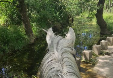
De tout petits portages suivant le niveau. Si trop d'eau au passage à gué, remontez un peu pour traverser.
Commentaire de l'auteur sur la sortie
Découverte et plaisir, avec une longueur de sortie très accessible.
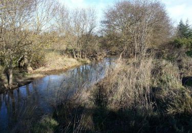
parcours en sous bois et monotraces alternant roulant et
technique
Positioning
Comments
Trails nearby
![Trail Mountain bike Castries - Près du Truc de l'Empereur - Fondespierre - Photo](https://media.geolcdn.com/t/375/260/ext.jpg?maxdim=2&url=https%3A%2F%2Fservices.sitytrail.com%2FGeolivesWS%2FDownloadMedia.ashx%3FTrailID%3D317565%26Media%3D16823_3.jpg)
![Mountain bike Mountain bike](https://static1.geolcdn.com/sitytour/trail-icons/202.png)
Mountain bike
![](/images/other/stat-length.png)
![](https://static1.geolcdn.com/siteimages/upload/files/16400158638029165_repeat_loop_refresh_sync_direction_icon.png)
![Trail Mountain bike Le Crès - Balade entre villages et garrigue - Le Crès - Photo](https://media.geolcdn.com/t/375/260/ext.jpg?maxdim=2&url=https%3A%2F%2Fservices.sitytrail.com%2FGeolivesWS%2FDownloadMedia.ashx%3FTrailID%3D118705%26Media%3D12880_2.jpg)
![Mountain bike Mountain bike](https://static1.geolcdn.com/sitytour/trail-icons/202.png)
Mountain bike
![](/images/other/stat-length.png)
![](https://static1.geolcdn.com/siteimages/upload/files/16400158638029165_repeat_loop_refresh_sync_direction_icon.png)
![Trail Walking Castries - 2022-12-01_18h50m59_Le tour de Bannières par les petits chemins - Photo](https://media.geolcdn.com/t/375/260/ext.jpg?maxdim=2&url=https%3A%2F%2Fstatic1.geolcdn.com%2Fsiteimages%2Fupload%2Ffiles%2F1553511878bg_sport_marche.png)
![Walking Walking](https://static1.geolcdn.com/sitytour/trail-icons/101.png)
Walking
![](/images/other/stat-length.png)
![](https://static1.geolcdn.com/siteimages/upload/files/16400158638029165_repeat_loop_refresh_sync_direction_icon.png)
![Trail Horseback riding Teyran - Teyran - domaine des Restinclières boucle - Photo](https://media.geolcdn.com/t/375/260/70e62699-5ded-495a-b1e7-d8ad791f0b3d.jpg&format=jpg&maxdim=2)
![Horseback riding Horseback riding](https://static1.geolcdn.com/sitytour/trail-icons/301.png)
Horseback riding
![](/images/other/stat-length.png)
![](https://static1.geolcdn.com/siteimages/upload/files/16400158638029165_repeat_loop_refresh_sync_direction_icon.png)
![Trail Walking Saint-Geniès-des-Mourgues - 30 beaulieu - Photo](https://media.geolcdn.com/t/375/260/e48acc05-ba85-4785-a34a-e2be2133d057.jpg&format=jpg&maxdim=2)
![Walking Walking](https://static1.geolcdn.com/sitytour/trail-icons/101.png)
Walking
![](/images/other/stat-length.png)
![](https://static1.geolcdn.com/siteimages/upload/files/16400158638029165_repeat_loop_refresh_sync_direction_icon.png)
![Trail Walking Castries - castries - Photo](https://media.geolcdn.com/t/375/260/06705112-3ee7-43dd-9317-ff37f2b0ce5e.jpg&format=jpg&maxdim=2)
![Walking Walking](https://static1.geolcdn.com/sitytour/trail-icons/101.png)
![Trail On foot Castries - Gazette: Castries le chemin de l'eau - Photo](https://media.geolcdn.com/t/375/260/ext.jpg?maxdim=2&url=https%3A%2F%2Fstatic1.geolcdn.com%2Fsiteimages%2Fupload%2Ffiles%2F1545311037marcheuse_200dpi.jpg)
![On foot On foot](https://static1.geolcdn.com/sitytour/trail-icons/100.png)
On foot
![](/images/other/stat-length.png)
![](https://static1.geolcdn.com/siteimages/upload/files/16400158638029165_repeat_loop_refresh_sync_direction_icon.png)
![Trail Walking Castries - 34 aqueducs de castrie - Photo](https://media.geolcdn.com/t/375/260/44ccf99b-49a8-4d97-9838-86cc5470db64.jpg&format=jpg&maxdim=2)
![Walking Walking](https://static1.geolcdn.com/sitytour/trail-icons/101.png)
Walking
![](/images/other/stat-length.png)
![](https://static1.geolcdn.com/siteimages/upload/files/16400158638029165_repeat_loop_refresh_sync_direction_icon.png)
![Trail Walking Le Crès - le Cres Lac et Salaison - Photo](https://media.geolcdn.com/t/375/260/ext.jpg?maxdim=2&url=https%3A%2F%2Fservices.sitytrail.com%2FGeolivesWS%2FDownloadMedia.ashx%3FTrailID%3D861189%26Media%3Dfix__20171112161650.jpg)
![Walking Walking](https://static1.geolcdn.com/sitytour/trail-icons/101.png)
Walking
![](/images/other/stat-length.png)
![](https://static1.geolcdn.com/siteimages/upload/files/16400158638029165_repeat_loop_refresh_sync_direction_icon.png)