Trail Trail Mamoudzou - Traversée S-N Jour 2 - Option2 - Photo

Traversée S-N Jour 2 - Option2

© OpenStreetMap contributors
Length
Length
38 km
Max alt
Max alt
567 m
Uphill gradient
Uphill gradient
1450 m
Km-Effort
Km-Effort  
58 km
Min alt
Min alt
9 m
Downhill gradient
Downhill gradient
1791 m
Boucle
Boucle
No
Creation date :
2021-08-11 08:01:34.088
Updated on :
2021-08-26 06:49:18.478

(0 Reviews)

Trail
Trail
5h00
Difficulty : Medium

Scan this QR Code to open this trail in the SityTrail application

FREE GPS app for hiking

Logo SityTrail SityTrail

IGN / Geographical institutes

Download SityTrail from the App Store Download SityTrail from Google Play

Logo SityTrail SityTrail World

The world is yours!

Download SityTrail from the App Store Download SityTrail from Google Play Download SityTrail on Huawei AppGallery

About

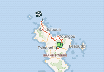
Trail Trail of 38 km to be discovered at Mayotte, Unknown, Mamoudzou. This trail is proposed by gromain1000.

Description

Seconde étape de la traversée de Mayotte sud-nord sur sentiers (principalement GR, mais aussi autres sentiers)

Elevation profile

Positioning

Country:
France
Region :
Mayotte
Department/Province :
Unknown
Municipality :
Mamoudzou
Location:
Unknown
Start:(UTM)
516783 ; 8584268 (38L) S.

Trails nearby

Trail Walking Tsingoni - Cascade de soulou - Combani - Photo
Walking
fsaysset

Walking

Medium
Tsingoni, Mayotte, Unknown, France
15.1 km | 19.6 km-effort
4h 30min
No
Trail Walking Tsingoni - Mont Combarieu - Photo
Walking
fsaysset

Walking

Difficult
Tsingoni, Mayotte, Unknown, France
7.5 km | 11.4 km-effort
1h 59min
No
Trail Walking Dembéni - Test - Photo
Walking
Elisa Lahely

Walking

Easy
Dembéni, Mayotte, Unknown, France
63 m | 63 m-effort
1min
No
Trail Mountain bike Tsingoni - retenu collinaire - Photo
Mountain bike
Pascalbahuaud

Mountain bike

Easy
Tsingoni, Mayotte, Unknown, France
1.1 km | 1.3 km-effort
21min
No


Close
My subscriptions