Trail Walking Molines-en-Queyras - Boucle du canal aux hameaux de Prats - Photo

Boucle du canal aux hameaux de Prats

 jpb83
jpb83

User

© OpenStreetMap contributors
Length
Length
8.7 km
Max alt
Max alt
1878 m
Uphill gradient
Uphill gradient
339 m
Km-Effort
Km-Effort  
13.3 km
Min alt
Min alt
1617 m
Downhill gradient
Downhill gradient
346 m
Boucle
Boucle
Yes
Creation date :
2021-08-09 06:57:26.627
Updated on :
2021-08-09 06:58:39.222

(0 Reviews)

Walking
Walking
3h00
Difficulty : Easy

Scan this QR Code to open this trail in the SityTrail application

FREE GPS app for hiking

Logo SityTrail SityTrail

IGN / Geographical institutes

Download SityTrail from the App Store Download SityTrail from Google Play

Logo SityTrail SityTrail World

The world is yours!

Download SityTrail from the App Store Download SityTrail from Google Play Download SityTrail on Huawei AppGallery

About

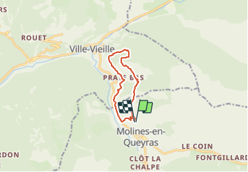
Trail Walking of 8.7 km to be discovered at Provence-Alpes-Côte d'Azur, Hautes-Alpes, Molines-en-Queyras. This trail is proposed by jpb83.

Description

On stationne au hameau Gaudissart qui domine Molines sur la route du Col Agnel. On se gare vers l'hôtel et les terrains de sport.

(D/A) On longe d'abord sur un sentier le canal de Pierre Dimanche, encore plein de neige en cette fin avril.

(1) Premier croisement, on va sur la gauche pour suivre le canal. On alterne entre balcons et forêts jusqu'au hameau de Prats Hauts.

(2) Sortie de Prats Hauts, on emprunte la route à droite en impasse, puis on prend à gauche la direction des panneaux Jaunes. On entre en forêt et là, le sentier est étonnamment balisé par une série de quelques cairns.

(3) Au croisement, on prend à gauche pour attaquer la descente en forêt.

(4) On arrive dans une petite clairière en rejoignant brièvement la piste forestière. Tout de suite, il faut partir sur la gauche pour remonter légèrement en forêt.

(5) On traverse la route pour poursuivre dans le chemin. Possibilité également de traverser le hameau de Prats Bas par la route puis, à la sortie, de rejoindre le GR®.

(6) On prend le chemin du milieu. Une fois la D5 rejointe, il faut soit revenir au point de départ (D/A) en longeant la route jusqu'à Gaudissart (il est possible de marcher dans l'herbe sur le côté gauche), soit couper à hauteur de l'hôtel visible plus haut (option représentée sur le tracé). Dans ce cas, on prend 150m de dénivelé d'un coup et sans répit.

Elevation profile

Points of interest

Point of interest Molines-en-Queyras - Parking terrain de sport - Photo
jpb83
MOLINES-EN-QUEYRAS 
Point of interest Molines-en-Queyras - Suivre le canal - Photo
jpb83
MOLINES-EN-QUEYRAS 
Point of interest Château-Ville-Vieille - À droite vers l'impasse - Photo
jpb83
CHÂTEAU-VILLE-VIEILLE 
Point of interest Château-Ville-Vieille - A gauche direction Aiguilles. - Photo
jpb83
CHÂTEAU-VILLE-VIEILLE 
Point of interest Château-Ville-Vieille - Descendre à gauche - Photo
jpb83
CHÂTEAU-VILLE-VIEILLE 
Point of interest Château-Ville-Vieille - Prendre à gauche vers le sentier - Photo
jpb83
CHÂTEAU-VILLE-VIEILLE 
Point of interest Château-Ville-Vieille - Traverser la route - Photo
jpb83
CHÂTEAU-VILLE-VIEILLE 
Point of interest Château-Ville-Vieille - Prendre au milieu. - Photo
jpb83
CHÂTEAU-VILLE-VIEILLE 
Point of interest Château-Ville-Vieille - Chemin du milieu - Photo
jpb83
CHÂTEAU-VILLE-VIEILLE 
Point of interest Molines-en-Queyras - Parking terrain de sport - Photo
jpb83
MOLINES-EN-QUEYRAS 

Positioning

Country:
France
Region :
Provence-Alpes-Côte d'Azur
Department/Province :
Hautes-Alpes
Municipality :
Molines-en-Queyras
Location:
Unknown
Start:(UTM)
329165 ; 4955801 (32T) N.

Trails nearby

Trail Walking Château-Ville-Vieille - Queyras j1 - Photo
Walking
Ninie38MD

Walking

Medium
(1)
Château-Ville-Vieille, Provence-Alpes-Côte d'Azur, Hautes-Alpes, France
19.1 km | 36 km-effort
8h 6min
No
Trail Walking Saint-Véran - Pic de Château Renard 2989 m - Photo
Walking
astro45

Walking

Medium
(1)
Saint-Véran, Provence-Alpes-Côte d'Azur, Hautes-Alpes, France
6.9 km | 16.1 km-effort
2h 43min
No
Trail Walking Saint-Véran - boucle St Veran - Refuge de la blanche - Photo
Walking
gildascb

Walking

Medium
(1)
Saint-Véran, Provence-Alpes-Côte d'Azur, Hautes-Alpes, France
19.3 km | 28 km-effort
5h 15min
Yes
Trail Mountain bike Château-Ville-Vieille - Tour du Queyras - Photo
Mountain bike
tracegps

Mountain bike

Very difficult
(1)
Château-Ville-Vieille, Provence-Alpes-Côte d'Azur, Hautes-Alpes, France
32 km | 50 km-effort
3h 0min
Yes
Trail Snowshoes Saint-Véran - Saint Véran - Col de Chamoussière - Pic de Caramantran - Refuge de la Blanche - Photo
Snowshoes
GUIDE
Pierre Lefèvre

Snowshoes

Difficult
Saint-Véran, Provence-Alpes-Côte d'Azur, Hautes-Alpes, France
22 km | 38 km-effort
5h 30min
Yes
Trail Snowshoes Molines-en-Queyras - Pont de Lariane - Col de Longet - Observatoire et Pic de Château Renard - Photo
Snowshoes
GUIDE
Pierre Lefèvre

Snowshoes

Medium
Molines-en-Queyras, Provence-Alpes-Côte d'Azur, Hautes-Alpes, France
16.1 km | 30 km-effort
5h 0min
Yes
Trail Walking Château-Ville-Vieille - Ville-vieille - Ceillac - Photo
Walking
GUIDE
romanceline

Walking

Medium
Château-Ville-Vieille, Provence-Alpes-Côte d'Azur, Hautes-Alpes, France
17.4 km | 31 km-effort
6h 51min
No
Trail Other activity Molines-en-Queyras - ski tour du Rouchon - Photo
Other activity
CYCLOHC

Other activity

Medium
(2)
Molines-en-Queyras, Provence-Alpes-Côte d'Azur, Hautes-Alpes, France
8.6 km | 20 km-effort
5h 24min
No
Trail Walking Saint-Véran - saint véranda les hameaux le champ et le raux - Photo
Walking
marchev

Walking

Easy
Saint-Véran, Provence-Alpes-Côte d'Azur, Hautes-Alpes, France
4.9 km | 7.9 km-effort
1h 44min
No


Close
My subscriptions