![](/images/other/stat-length.png)
![Trail On foot Méhers - Mehers 8 août 2021 - Photo](https://media.geolcdn.com/t/1900/400/2c27c651-b144-43b7-9d95-1f985e6049d3.jpg&format=pjpeg&maxdim=2)
Mehers 8 août 2021
Roro41
User
![Length](/images/other/stat-length.png)
Length
10.9 km
![Max alt](https://static1.geolcdn.com/siteimages/upload/files/1508320355ic_sort_altitude_max_24dp.png)
Max alt
98 m
![Uphill gradient](https://static1.geolcdn.com/siteimages/upload/files/1508320355ic_sort_den_pos_24dp.png)
Uphill gradient
57 m
![Km-Effort](/images/other/stat-length.png)
Km-Effort
11.7 km
![Min alt](https://static1.geolcdn.com/siteimages/upload/files/1508320355ic_sort_altitude_min_24dp.png)
Min alt
79 m
![Downhill gradient](https://static1.geolcdn.com/siteimages/upload/files/1508320355ic_sort_den_neg_24dp.png)
Downhill gradient
58 m
![Boucle](https://static1.geolcdn.com/siteimages/upload/files/16400158638029165_repeat_loop_refresh_sync_direction_icon.png)
Boucle
Yes
Creation date :
2021-08-08 06:39:01.386
Updated on :
2021-08-09 15:19:10.24
![On foot](https://static1.geolcdn.com/sitytour/trail-icons/100.png)
2h39
Difficulty : Easy
![Scan this QR Code to open this trail in the SityTrail application](https://capi.geolives.com/qq0zvz2zws4bq2lad0pu/sitytour/trails/2889726/qr.png?size=200)
FREE GPS app for hiking
About
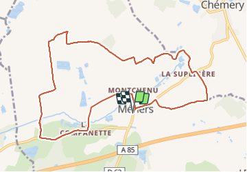
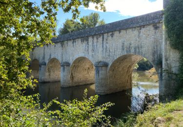
Trail On foot of 10.9 km to be discovered at Centre-Loire Valley, Loir-et-Cher, Méhers. This trail is proposed by Roro41.
Description
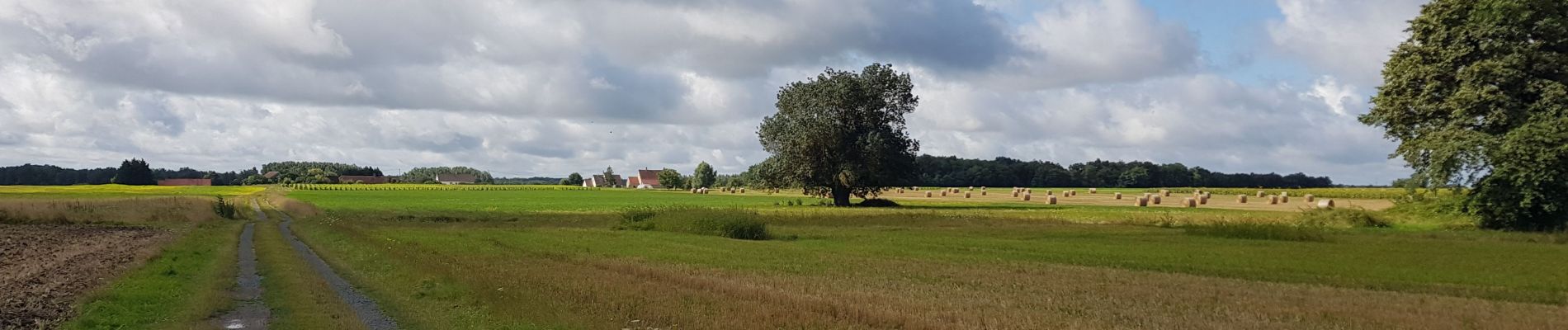
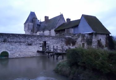
Marche en plaine entre cultures et vignobles. Passage près du château manoir de Beauregard construit dans les premières années du 16e siècle.
Positioning
Country:
France
Region :
Centre-Loire Valley
Department/Province :
Loir-et-Cher
Municipality :
Méhers
Location:
Unknown
Start:(Dec)
Start:(UTM)
383338 ; 5242671 (31T) N.
Comments
Trails nearby
![Trail sport Chémery - Sob 11 chemery selles sur cher - Photo](https://media.geolcdn.com/t/375/260/023ea4d6-5f56-416d-95d9-c67d7bc970f7.jpg&format=jpg&maxdim=2)
Sob 11 chemery selles sur cher
sport
Very easy
Chémery,
Centre-Loire Valley,
Loir-et-Cher,
France
![](/images/other/stat-length.png)
24 km | 27 km-effort
Unknown
![](https://static1.geolcdn.com/siteimages/upload/files/16400158638029165_repeat_loop_refresh_sync_direction_icon.png)
No
![Trail Walking Chémery - chemery 2019 - Photo](https://media.geolcdn.com/t/375/260/74a7a3af-7994-42bd-8d40-b60aa8c3cfc3.jpg&format=jpg&maxdim=2)
![Walking Walking](https://static1.geolcdn.com/sitytour/trail-icons/101.png)
chemery 2019
Walking
Very easy
Chémery,
Centre-Loire Valley,
Loir-et-Cher,
France
![](/images/other/stat-length.png)
14.8 km | 16.3 km-effort
2h 59min
![](https://static1.geolcdn.com/siteimages/upload/files/16400158638029165_repeat_loop_refresh_sync_direction_icon.png)
Yes
![Trail On foot Chémery - chemery GS 2024 petit - Photo](https://media.geolcdn.com/t/375/260/ext.jpg?maxdim=2&url=https%3A%2F%2Fstatic1.geolcdn.com%2Fsiteimages%2Fupload%2Ffiles%2F1545311037marcheuse_200dpi.jpg)
![On foot On foot](https://static1.geolcdn.com/sitytour/trail-icons/100.png)
chemery GS 2024 petit
On foot
Easy
Chémery,
Centre-Loire Valley,
Loir-et-Cher,
France
![](/images/other/stat-length.png)
10.1 km | 10.9 km-effort
2h 28min
![](https://static1.geolcdn.com/siteimages/upload/files/16400158638029165_repeat_loop_refresh_sync_direction_icon.png)
Yes
![Trail Walking Couddes - couddes GS 03 2023 - Photo](https://media.geolcdn.com/t/375/260/ext.jpg?maxdim=2&url=https%3A%2F%2Fstatic1.geolcdn.com%2Fsiteimages%2Fupload%2Ffiles%2F1553511878bg_sport_marche.png)
![Walking Walking](https://static1.geolcdn.com/sitytour/trail-icons/101.png)
couddes GS 03 2023
Walking
Easy
Couddes,
Centre-Loire Valley,
Loir-et-Cher,
France
![](/images/other/stat-length.png)
13.6 km | 14.9 km-effort
3h 0min
![](https://static1.geolcdn.com/siteimages/upload/files/16400158638029165_repeat_loop_refresh_sync_direction_icon.png)
Yes
![Trail Walking Chémery - chémery - Photo](https://media.geolcdn.com/t/375/260/ext.jpg?maxdim=2&url=https%3A%2F%2Fstatic1.geolcdn.com%2Fsiteimages%2Fupload%2Ffiles%2F1553511878bg_sport_marche.png)
![Walking Walking](https://static1.geolcdn.com/sitytour/trail-icons/101.png)
chémery
Walking
Medium
Chémery,
Centre-Loire Valley,
Loir-et-Cher,
France
![](/images/other/stat-length.png)
26 km | 28 km-effort
4h 18min
![](https://static1.geolcdn.com/siteimages/upload/files/16400158638029165_repeat_loop_refresh_sync_direction_icon.png)
Yes
![Trail Walking Chémery - çhemery - Photo](https://media.geolcdn.com/t/375/260/ext.jpg?maxdim=2&url=https%3A%2F%2Fstatic1.geolcdn.com%2Fsiteimages%2Fupload%2Ffiles%2F1553511878bg_sport_marche.png)
![Walking Walking](https://static1.geolcdn.com/sitytour/trail-icons/101.png)
çhemery
Walking
Easy
Chémery,
Centre-Loire Valley,
Loir-et-Cher,
France
![](/images/other/stat-length.png)
19.6 km | 22 km-effort
3h 17min
![](https://static1.geolcdn.com/siteimages/upload/files/16400158638029165_repeat_loop_refresh_sync_direction_icon.png)
Yes
![Trail On foot Chémery - chemery GS 2022 - Photo](https://media.geolcdn.com/t/375/260/ext.jpg?maxdim=2&url=https%3A%2F%2Fstatic1.geolcdn.com%2Fsiteimages%2Fupload%2Ffiles%2F1545311037marcheuse_200dpi.jpg)
![On foot On foot](https://static1.geolcdn.com/sitytour/trail-icons/100.png)
chemery GS 2022
On foot
Easy
Chémery,
Centre-Loire Valley,
Loir-et-Cher,
France
![](/images/other/stat-length.png)
14.5 km | 15.5 km-effort
3h 0min
![](https://static1.geolcdn.com/siteimages/upload/files/16400158638029165_repeat_loop_refresh_sync_direction_icon.png)
Yes
![Trail Walking Saint-Romain-sur-Cher - st romain GS 02/11/2021 petit - Photo](https://media.geolcdn.com/t/375/260/ext.jpg?maxdim=2&url=https%3A%2F%2Fstatic1.geolcdn.com%2Fsiteimages%2Fupload%2Ffiles%2F1553511878bg_sport_marche.png)
![Walking Walking](https://static1.geolcdn.com/sitytour/trail-icons/101.png)
st romain GS 02/11/2021 petit
Walking
Difficult
Saint-Romain-sur-Cher,
Centre-Loire Valley,
Loir-et-Cher,
France
![](/images/other/stat-length.png)
13.4 km | 15.2 km-effort
3h 27min
![](https://static1.geolcdn.com/siteimages/upload/files/16400158638029165_repeat_loop_refresh_sync_direction_icon.png)
Yes
![Trail Walking Chémery - chemery - Photo](https://media.geolcdn.com/t/375/260/ext.jpg?maxdim=2&url=https%3A%2F%2Fstatic1.geolcdn.com%2Fsiteimages%2Fupload%2Ffiles%2F1553511878bg_sport_marche.png)
![Walking Walking](https://static1.geolcdn.com/sitytour/trail-icons/101.png)
chemery
Walking
Very easy
Chémery,
Centre-Loire Valley,
Loir-et-Cher,
France
![](/images/other/stat-length.png)
14.4 km | 15.5 km-effort
2h 50min
![](https://static1.geolcdn.com/siteimages/upload/files/16400158638029165_repeat_loop_refresh_sync_direction_icon.png)
Yes