Trail Walking Val-des-Prés - le rosier - ravin de l'enrouye - la vachette - Photo

le rosier - ravin de l'enrouye - la vachette

 hueco
hueco

User

© OpenStreetMap contributors
Length
Length
5.9 km
Max alt
Max alt
1621 m
Uphill gradient
Uphill gradient
339 m
Km-Effort
Km-Effort  
10.5 km
Min alt
Min alt
1356 m
Downhill gradient
Downhill gradient
365 m
Boucle
Boucle
No
Creation date :
2021-08-07 13:19:10.43
Updated on :
2021-08-07 15:15:38.672

(0 Reviews)

Walking
Walking
1h54
Difficulty : Medium

Scan this QR Code to open this trail in the SityTrail application

FREE GPS app for hiking

Logo SityTrail SityTrail

IGN / Geographical institutes

Download SityTrail from the App Store Download SityTrail from Google Play

Logo SityTrail SityTrail World

The world is yours!

Download SityTrail from the App Store Download SityTrail from Google Play Download SityTrail on Huawei AppGallery

About

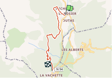
Trail Walking of 5.9 km to be discovered at Provence-Alpes-Côte d'Azur, Hautes-Alpes, Val-des-Prés. This trail is proposed by hueco.

Description

le dénivelé positif de 240m se fait sur 1km au panneau La Vachette 5km

Elevation profile

Positioning

Country:
France
Region :
Provence-Alpes-Côte d'Azur
Department/Province :
Hautes-Alpes
Municipality :
Val-des-Prés
Location:
Unknown
Start:(UTM)
317037 ; 4978890 (32T) N.

Trails nearby

Trail Walking Montgenèvre - Le Chaberton - Photo
Walking
GUIDE
R@ph

Walking

Difficult
(2)
Montgenèvre, Provence-Alpes-Côte d'Azur, Hautes-Alpes, France
15.4 km | 32 km-effort
6h 15min
Yes
Trail Walking Briançon - Briançon Schappe-3 têtes - Photo
Walking
GUIDE
Orcal37

Walking

Easy
(2)
Briançon, Provence-Alpes-Côte d'Azur, Hautes-Alpes, France
6.5 km | 11 km-effort
2h 5min
Yes
Trail Mountain bike Val-des-Prés - Montgenèvre et col de la Lauze - Photo
Mountain bike
tracegps

Mountain bike

Very difficult
(1)
Val-des-Prés, Provence-Alpes-Côte d'Azur, Hautes-Alpes, France
38 km | 57 km-effort
3h 30min
Yes
Trail Walking Montgenèvre - Montgenevre Replat du Gondran 240830 - Photo
Walking
GUIDE
Specialized77

Walking

Easy
Montgenèvre, Provence-Alpes-Côte d'Azur, Hautes-Alpes, France
9.1 km | 14 km-effort
3h 10min
No
Trail Walking Montgenèvre - Mont Chaberton (Hautes-Alpes) - Photo
Walking
GUIDE
toutankhcarton

Walking

Difficult
Montgenèvre, Provence-Alpes-Côte d'Azur, Hautes-Alpes, France
15 km | 32 km-effort
5h 7min
Yes
Trail Walking Montgenèvre - le mont Chaberton - Photo
Walking
GUIDE
amiral13

Walking

Medium
(1)
Montgenèvre, Provence-Alpes-Côte d'Azur, Hautes-Alpes, France
16.4 km | 33 km-effort
8h 48min
Yes
Trail Walking Montgenèvre - Les crêtes du Chalvet - Photo
Walking
GUIDE
amiral13

Walking

Medium
Montgenèvre, Provence-Alpes-Côte d'Azur, Hautes-Alpes, France
12 km | 23 km-effort
6h 3min
Yes
Trail Walking Montgenèvre - le sommet de Château Jouan et le fort de Janus - Photo
Walking
GUIDE
amiral13

Walking

Difficult
Montgenèvre, Provence-Alpes-Côte d'Azur, Hautes-Alpes, France
13.8 km | 24 km-effort
4h 15min
Yes
Trail Walking Briançon - Circuit: Fort des 3 Têtes et Fort Dauphin - Photo
Walking
GUIDE
lhomme.ph

Walking

Easy
(2)
Briançon, Provence-Alpes-Côte d'Azur, Hautes-Alpes, France
7.4 km | 11.9 km-effort
2h 40min
Yes


Close
My subscriptions