Trail Walking Montgenèvre - 2021-08-07_09h12m55_le-tour-du-bois-de-sestrieres - Photo

2021-08-07_09h12m55_le-tour-du-bois-de-sestrieres

 jpb83
jpb83

User

© OpenStreetMap contributors
Length
Length
7.4 km
Max alt
Max alt
1848 m
Uphill gradient
Uphill gradient
287 m
Km-Effort
Km-Effort  
11.2 km
Min alt
Min alt
1613 m
Downhill gradient
Downhill gradient
287 m
Boucle
Boucle
Yes
Creation date :
2021-08-07 07:12:55.788
Updated on :
2021-08-07 19:57:53.133

(0 Reviews)

Walking
Walking
2h32
Difficulty : Very easy
Running
Running
--
Difficulty : Easy

Scan this QR Code to open this trail in the SityTrail application

FREE GPS app for hiking

Logo SityTrail SityTrail

IGN / Geographical institutes

Download SityTrail from the App Store Download SityTrail from Google Play

Logo SityTrail SityTrail World

The world is yours!

Download SityTrail from the App Store Download SityTrail from Google Play Download SityTrail on Huawei AppGallery

About

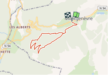
Trail Walking of 7.4 km to be discovered at Provence-Alpes-Côte d'Azur, Hautes-Alpes, Montgenèvre. This trail is proposed by jpb83.

Description

Cette jolie petite balade familiale vous fera découvrir une forêt de mélèzes sur un itinéraire large et peu pentu jusqu’à un point de vue sur Briançon et ses forts.
Cet itinéraire vous fera descendre en direction du lieu dit de Pierre Verte avant de remonter jusqu'au belvédère où un magnifique panorama sur le fort Dauphin, le fort des Têtes et le début de la vallée de la Clarée vous attend.
Départ / Arrivée : Parking des Chalmettes, Montgenèvre
Depuis le le parking des Chalmettes:

   Rejoindre le centre Durancia. Emprunter le sentier qui longe le bâtiment sur la gauche (direction Espace multi-activité).
   Au pont de la Durance, tourner à droite sur le chemin du bois de Sestrières.
   Tout de suite après l'aire de pique-nique, emprunter le sentier qui descend sur la droite (direction le tour du bois). Descendre jusqu'à Pierre verte.
   Là, tourner à gauche direction Montgenèvre pour suivre une piste qui remonte en lacets jusqu'au belvédère pour profiter d'une magnifique vue sur le fort Dauphin et le fort des Têtes.
   Au belvédère, poursuivre la piste forestière jusqu'à votre point de départ.

Elevation profile

Positioning

Country:
France
Region :
Provence-Alpes-Côte d'Azur
Department/Province :
Hautes-Alpes
Municipality :
Montgenèvre
Location:
Unknown
Start:(UTM)
319659 ; 4977572 (32T) N.

Trails nearby

Trail Walking Montgenèvre - Le Chaberton - Photo
Walking
GUIDE
R@ph

Walking

Difficult
(2)
Montgenèvre, Provence-Alpes-Côte d'Azur, Hautes-Alpes, France
15.4 km | 32 km-effort
6h 15min
Yes
Trail Mountain bike Val-des-Prés - Montgenèvre et col de la Lauze - Photo
Mountain bike
tracegps

Mountain bike

Very difficult
(1)
Val-des-Prés, Provence-Alpes-Côte d'Azur, Hautes-Alpes, France
38 km | 57 km-effort
3h 30min
Yes
Trail Walking Montgenèvre - Montgenevre Replat du Gondran 240830 - Photo
Walking
GUIDE
Specialized77

Walking

Easy
Montgenèvre, Provence-Alpes-Côte d'Azur, Hautes-Alpes, France
9.1 km | 14 km-effort
3h 10min
No
Trail Walking Montgenèvre - Mont Chaberton (Hautes-Alpes) - Photo
Walking
GUIDE
toutankhcarton

Walking

Difficult
Montgenèvre, Provence-Alpes-Côte d'Azur, Hautes-Alpes, France
15 km | 32 km-effort
5h 7min
Yes
Trail Walking Montgenèvre - le mont Chaberton - Photo
Walking
GUIDE
amiral13

Walking

Medium
(1)
Montgenèvre, Provence-Alpes-Côte d'Azur, Hautes-Alpes, France
16.4 km | 33 km-effort
8h 48min
Yes
Trail Walking Montgenèvre - Les crêtes du Chalvet - Photo
Walking
GUIDE
amiral13

Walking

Medium
Montgenèvre, Provence-Alpes-Côte d'Azur, Hautes-Alpes, France
12 km | 23 km-effort
6h 3min
Yes
Trail Walking Val-des-Prés - le Chenaillet et le grand charvia - Photo
Walking
GUIDE
amiral13

Walking

Medium
Val-des-Prés, Provence-Alpes-Côte d'Azur, Hautes-Alpes, France
11.3 km | 19.5 km-effort
4h 17min
No
Trail Walking Montgenèvre - le sommet de Château Jouan et le fort de Janus - Photo
Walking
GUIDE
amiral13

Walking

Difficult
Montgenèvre, Provence-Alpes-Côte d'Azur, Hautes-Alpes, France
13.8 km | 24 km-effort
4h 15min
Yes
Trail Mountain bike Montgenèvre - tour de montgenevre - Photo
Mountain bike
Vincentetourmy

Mountain bike

Very difficult
(1)
Montgenèvre, Provence-Alpes-Côte d'Azur, Hautes-Alpes, France
32 km | 50 km-effort
3h 15min
Yes


Close
My subscriptions