Trail Walking Briançon - 2021-08-07_09h09m02_la-via-guisane - Photo

2021-08-07_09h09m02_la-via-guisane

 jpb83
jpb83

User

© OpenStreetMap contributors
Length
Length
9.7 km
Max alt
Max alt
1342 m
Uphill gradient
Uphill gradient
179 m
Km-Effort
Km-Effort  
12.1 km
Min alt
Min alt
1206 m
Downhill gradient
Downhill gradient
177 m
Boucle
Boucle
Yes
Creation date :
2021-08-07 07:09:02.111
Updated on :
2021-08-07 19:55:08.655

(0 Reviews)

Walking
Walking
2h44
Difficulty : Very easy
Running
Running
1h00
Difficulty : Very easy

Scan this QR Code to open this trail in the SityTrail application

FREE GPS app for hiking

Logo SityTrail SityTrail

IGN / Geographical institutes

Download SityTrail from the App Store Download SityTrail from Google Play

Logo SityTrail SityTrail World

The world is yours!

Download SityTrail from the App Store Download SityTrail from Google Play Download SityTrail on Huawei AppGallery

About

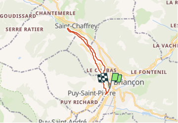
Trail Walking of 9.7 km to be discovered at Provence-Alpes-Côte d'Azur, Hautes-Alpes, Briançon. This trail is proposed by jpb83.

Description

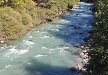
Le parcours des canaux sur le versant nord permet de faire un parcours dont une bonne partie est en forêt entre Briançon et Chantemerle.
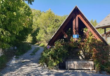
Parcours au coeur de la forêt et longeant canal et rivière.
Départ : Avenue René Froger, Briançon
Arrivée : Avenue René Froger Briançon
Communes traversées : Briançon, Saint-Chaffrey, Puy-Saint-Pierre
Stationner votre véhicule et longer la Guisane jusqu'à rejoindre le magasin de bricolage situé sur l'avenue de Provence.

   Prendre le sentier qui se situe à côté du pont sur la Guisane jusqu’à l’intersection du chemin de Forville (à 1 km).
   Suivre la route vers la gauche en descendant. Laisser le pont pour continuer tout droit le long de la route sous les pins jusqu’au virage en épingle (pont du Martinet).
   Laisser la route pour emprunter le sentier longeant la rivière en direction de pont Carles par le sentier « Guisane ».
   Traverser successivement le pont (au-dessus du torrent du Verdarel) puis le pont Carles (au-dessus de la Guisane).
Désormais sur la rive droite de la Guisane, prendre le canal des Queyrelles et poursuivre jusqu'à rejoindre la route qui monte à Puy Saint Pierre.

Redescendre pour traverser le carrefour et rejoindre le parking

Elevation profile

Positioning

Country:
France
Region :
Provence-Alpes-Côte d'Azur
Department/Province :
Hautes-Alpes
Municipality :
Briançon
Location:
Unknown
Start:(UTM)
312918 ; 4974024 (32T) N.

Trails nearby

Trail Walking Briançon - Briançon Schappe-3 têtes - Photo
Walking
GUIDE
Orcal37

Walking

Easy
(2)
Briançon, Provence-Alpes-Côte d'Azur, Hautes-Alpes, France
6.5 km | 11 km-effort
2h 5min
Yes
Trail Mountain bike Val-des-Prés - Montgenèvre et col de la Lauze - Photo
Mountain bike
tracegps

Mountain bike

Very difficult
(1)
Val-des-Prés, Provence-Alpes-Côte d'Azur, Hautes-Alpes, France
38 km | 57 km-effort
3h 30min
Yes
Trail Trail Puy-Saint-André - Clos du Vas - Puy Chalvin - Photo
Trail
GUIDE
toutankhcarton

Trail

Medium
Puy-Saint-André, Provence-Alpes-Côte d'Azur, Hautes-Alpes, France
7.4 km | 13.4 km-effort
1h 30min
Yes
Trail Running Puy-Saint-André - Clos du Vas - St Blaise - Briançon - Villar St Pancrace (Hautes-Alpes) - Photo
Running
GUIDE
toutankhcarton

Running

Medium
Puy-Saint-André, Provence-Alpes-Côte d'Azur, Hautes-Alpes, France
8 km | 10 km-effort
1h 7min
Yes
Trail Walking Saint-Chaffrey - Chantemerle-la Salle les Aples 13-08-2018 - Photo
Walking
GUIDE
fredetpascale

Walking

Easy
(1)
Saint-Chaffrey, Provence-Alpes-Côte d'Azur, Hautes-Alpes, France
9.7 km | 15.9 km-effort
2h 56min
No
Trail Walking Puy-Saint-André - cime de la condamine - Photo
Walking
GUIDE
amiral13

Walking

Difficult
Puy-Saint-André, Provence-Alpes-Côte d'Azur, Hautes-Alpes, France
13.7 km | 28 km-effort
5h 59min
Yes
Trail Walking Briançon - Circuit: Fort des 3 Têtes et Fort Dauphin - Photo
Walking
GUIDE
lhomme.ph

Walking

Easy
(2)
Briançon, Provence-Alpes-Côte d'Azur, Hautes-Alpes, France
7.4 km | 11.9 km-effort
2h 40min
Yes
Trail Walking Briançon - Briancon: Fort des Trois tètes - Photo
Walking
GUIDE
lhomme.ph

Walking

Very easy
Briançon, Provence-Alpes-Côte d'Azur, Hautes-Alpes, France
5 km | 8.5 km-effort
2h 8min
Yes
Trail Walking Briançon - Briancon: Le tour du Fort des 3 Têtes   - Photo
Walking
GUIDE
lhomme.ph

Walking

Medium
(1)
Briançon, Provence-Alpes-Côte d'Azur, Hautes-Alpes, France
7.7 km | 12.7 km-effort
1h 50min
Yes


Close
My subscriptions