Trail Walking La Salle-les-Alpes - 2021-08-07_08h55m47_la-cime-de-puy-la-salle - Photo

2021-08-07_08h55m47_la-cime-de-puy-la-salle

 jpb83
jpb83

User

© OpenStreetMap contributors
Length
Length
7 km
Max alt
Max alt
1983 m
Uphill gradient
Uphill gradient
537 m
Km-Effort
Km-Effort  
14.1 km
Min alt
Min alt
1438 m
Downhill gradient
Downhill gradient
537 m
Boucle
Boucle
Yes
Creation date :
2021-08-07 06:55:47.898
Updated on :
2021-08-07 19:49:56.167

(0 Reviews)

Walking
Walking
3h12
Difficulty : Difficult

Scan this QR Code to open this trail in the SityTrail application

FREE GPS app for hiking

Logo SityTrail SityTrail

IGN / Geographical institutes

Download SityTrail from the App Store Download SityTrail from Google Play

Logo SityTrail SityTrail World

The world is yours!

Download SityTrail from the App Store Download SityTrail from Google Play Download SityTrail on Huawei AppGallery

About

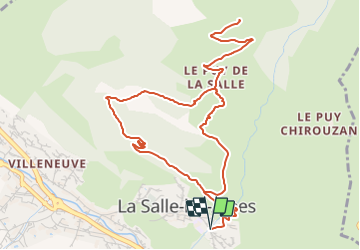
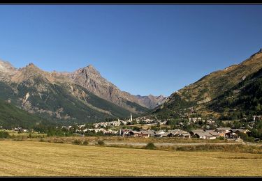
Trail Walking of 7 km to be discovered at Provence-Alpes-Côte d'Azur, Hautes-Alpes, La Salle-les-Alpes. This trail is proposed by jpb83.

Description

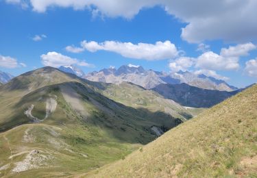
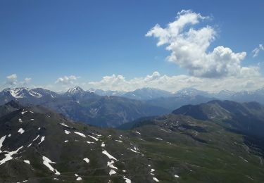
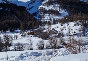
Promenade courte à proximité de Villeneuve, beau point de vue sur le massif et le domaine d'altitude.
Sur le versant sud, cette promenade chemine progressivement le long du Torrent de la Salle.
Départ / Arrivée : Entrée du village de la Salle - Coté Sud
Emprunter le chemin carrossable qui s'élève juste avant le pont, à l'entrée sud du village de La Salle.

Monter en direction des maisons de "Rivo".

1- Après avoir traverser le torrent continuer avant de bifurquer à droite en direction des Tures.

Aux chalets des Thures tenir le sentier à droite et continuer la progression jusqu'aux chalets d'alpage de Puy la Salle (1880 m).
Gagner ensuite la Cime de Puy la Salle, 100 mètres plus haut (1980 m).

2 - Pour le retour, emprunter le sentier qui redescend vers "le Piré" puis revenir par une autre route de terre qui revient au village de la Salle.

Elevation profile

Positioning

Country:
France
Region :
Provence-Alpes-Côte d'Azur
Department/Province :
Hautes-Alpes
Municipality :
La Salle-les-Alpes
Location:
Unknown
Start:(UTM)
308605 ; 4979588 (32T) N.

Trails nearby

Trail Walking Saint-Chaffrey - le Prorel au départ de la Serre Chevalier - Photo
Walking
GUIDE
amiral13

Walking

Easy
Saint-Chaffrey, Provence-Alpes-Côte d'Azur, Hautes-Alpes, France
7.9 km | 13.8 km-effort
3h 41min
Yes
Trail Walking La Salle-les-Alpes - le grand Aréa (boucle) - Photo
Walking
GUIDE
amiral13

Walking

Medium
La Salle-les-Alpes, Provence-Alpes-Côte d'Azur, Hautes-Alpes, France
7.7 km | 17.1 km-effort
4h 49min
Yes
Trail Walking La Salle-les-Alpes - Grand AREA 21/06/18 - Photo
Walking
GUIDE
R@ph

Walking

Difficult
La Salle-les-Alpes, Provence-Alpes-Côte d'Azur, Hautes-Alpes, France
9.4 km | 18.5 km-effort
3h 41min
Yes
Trail Mountain bike Saint-Chaffrey - granons tronchet - Photo
Mountain bike
Vincentetourmy

Mountain bike

Difficult
(1)
Saint-Chaffrey, Provence-Alpes-Côte d'Azur, Hautes-Alpes, France
15.5 km | 24 km-effort
1h 52min
No
Trail Walking Le Monêtier-les-Bains - tour de la cucumelle  - Photo
Walking
tchoua

Walking

Medium
Le Monêtier-les-Bains, Provence-Alpes-Côte d'Azur, Hautes-Alpes, France
21 km | 38 km-effort
5h 5min
Yes
Trail Walking Le Monêtier-les-Bains - Les Boussardes - Photo
Walking
LANDRIEU

Walking

Easy
Le Monêtier-les-Bains, Provence-Alpes-Côte d'Azur, Hautes-Alpes, France
15.7 km | 19.2 km-effort
5h 1min
No
Trail Walking Saint-Chaffrey - col du granon-croix de la cime - Photo
Walking
RayFab

Walking

Medium
Saint-Chaffrey, Provence-Alpes-Côte d'Azur, Hautes-Alpes, France
6.5 km | 10.7 km-effort
1h 59min
Yes
Trail Walking Le Monêtier-les-Bains - Grand Aréa - Photo
Walking
flip38

Walking

Difficult
Le Monêtier-les-Bains, Provence-Alpes-Côte d'Azur, Hautes-Alpes, France
25 km | 46 km-effort
8h 1min
Yes
Trail Walking Le Monêtier-les-Bains - 20210229 - Photo
Walking
Georges Mathys

Walking

Easy
Le Monêtier-les-Bains, Provence-Alpes-Côte d'Azur, Hautes-Alpes, France
3.6 km | 6.3 km-effort
1h 27min
No


Close
My subscriptions