Trail Walking Laviolle - le Villaret - Photo
© OpenStreetMap contributors
Length
Length
13.9 km
Max alt
Max alt
975 m
Uphill gradient
Uphill gradient
482 m
Km-Effort
Km-Effort  
21 km
Min alt
Min alt
425 m
Downhill gradient
Downhill gradient
684 m
Boucle
Boucle
No
Creation date :
2021-08-05 08:24:06.403
Updated on :
2021-08-05 11:44:26.282

(0 Reviews)

Walking
Walking
2h40
Difficulty : Medium

Scan this QR Code to open this trail in the SityTrail application

FREE GPS app for hiking

Logo SityTrail SityTrail

IGN / Geographical institutes

Download SityTrail from the App Store Download SityTrail from Google Play

Logo SityTrail SityTrail World

The world is yours!

Download SityTrail from the App Store Download SityTrail from Google Play Download SityTrail on Huawei AppGallery

About

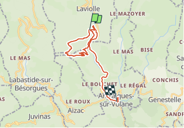
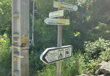
Trail Walking of 13.9 km to be discovered at Auvergne-Rhône-Alpes, Ardèche, Laviolle. This trail is proposed by Mariecoco.

Description

Calade montante pendant 2 km puis descente à travers bois jusqu'à la Volane et retour au Villaret.

Elevation profile

Positioning

Country:
France
Region :
Auvergne-Rhône-Alpes
Department/Province :
Ardèche
Municipality :
Laviolle
Location:
Unknown
Start:(UTM)
606037 ; 4956283 (31T) N.

Trails nearby

Trail Walking Vallées-d'Antraigues-Asperjoc - 07 antraigues - Photo
Walking
GUIDE
randodyssée

Walking

Difficult
Vallées-d'Antraigues-Asperjoc, Auvergne-Rhône-Alpes, Ardèche, France
14.4 km | 24 km-effort
7h 0min
Yes
Trail Walking Labastide-sur-Bésorgues - 2022-02-01_15h56m32_Les granges de Sausses 14,5km.GPX.xml - Photo
Walking
chancha

Walking

Difficult
(1)
Labastide-sur-Bésorgues, Auvergne-Rhône-Alpes, Ardèche, France
14.1 km | 24 km-effort
5h 37min
Yes
Trail Walking Aizac - SityTrail - 2231069 - aizacxmal-combexla-bastide-sur-besorgue- - Photo
Walking
coureursdecretes

Walking

Difficult
(1)
Aizac, Auvergne-Rhône-Alpes, Ardèche, France
10.3 km | 17.4 km-effort
3h 57min
Yes
Trail Walking Aizac - Aizac et la coupe d'Aizac - Photo
Walking
mikaou.t

Walking

Easy
(1)
Aizac, Auvergne-Rhône-Alpes, Ardèche, France
4.5 km | 7.5 km-effort
1h 24min
Yes
Trail Walking Vallées-d'Antraigues-Asperjoc - 07_antraigues_7km400m - Photo
Walking
SyMA

Walking

Easy
Vallées-d'Antraigues-Asperjoc, Auvergne-Rhône-Alpes, Ardèche, France
8.6 km | 13.2 km-effort
3h 7min
Yes
Trail Walking Vallées-d'Antraigues-Asperjoc - Antraigues - Photo
Walking
cousam

Walking

Medium
Vallées-d'Antraigues-Asperjoc, Auvergne-Rhône-Alpes, Ardèche, France
14.1 km | 23 km-effort
6h 58min
Yes
Trail Walking Labastide-sur-Bésorgues - la Bastide sur bezorgie - Photo
Walking
matrixe07

Walking

Easy
Labastide-sur-Bésorgues, Auvergne-Rhône-Alpes, Ardèche, France
34 km | 47 km-effort
5h 0min
No
Trail Walking Vallées-d'Antraigues-Asperjoc - Le Mazoyer - Le rocher des aigles - Photo
Walking
coureursdecretes

Walking

Very difficult
Vallées-d'Antraigues-Asperjoc, Auvergne-Rhône-Alpes, Ardèche, France
12.8 km | 21 km-effort
5h 46min
Yes
Trail Walking Vallées-d'Antraigues-Asperjoc - Antraïgues-Gamondes 17km - Photo
Walking
GUIDE
thonyc

Walking

Difficult
Vallées-d'Antraigues-Asperjoc, Auvergne-Rhône-Alpes, Ardèche, France
17.1 km | 25 km-effort
5h 30min
Yes


Close
My subscriptions