Trail Walking Saou - Petit Pomerolle par Lestang - Photo

Petit Pomerolle par Lestang

© OpenStreetMap contributors
Length
Length
12.9 km
Max alt
Max alt
882 m
Uphill gradient
Uphill gradient
569 m
Km-Effort
Km-Effort  
21 km
Min alt
Min alt
366 m
Downhill gradient
Downhill gradient
569 m
Boucle
Boucle
Yes
Creation date :
2021-07-31 06:29:26.076
Updated on :
2021-07-31 14:52:40.1

(0 Reviews)

Walking
Walking
3h45
Difficulty : Medium

Scan this QR Code to open this trail in the SityTrail application

FREE GPS app for hiking

Logo SityTrail SityTrail

IGN / Geographical institutes

Download SityTrail from the App Store Download SityTrail from Google Play

Logo SityTrail SityTrail World

The world is yours!

Download SityTrail from the App Store Download SityTrail from Google Play Download SityTrail on Huawei AppGallery

About

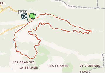
Trail Walking of 12.9 km to be discovered at Auvergne-Rhône-Alpes, Drôme, Saou. This trail is proposed by Philindy26.

Description

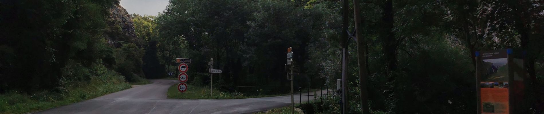
Départ du Pertuis à l'entrée de la Forêt de Saoû,,,
Géolocalisation (Google Maps) : https://goo.gl/maps/NqfA4zcwDxYSV2xo8

Traverser le ruisseau de la Vèbre et prendre la direction du Pas de Lestang (370 m), la Pointe des Étangs (365 m) et la Ferme de Lestang (375 m)...
Là direction le Pas de Berlhe (884 m) puis le Petit Pomerolle (820 m)...
Descente par les Clos (570 m), la Route Touristique Maurice Burrus (480 m) et la Vélo Voie Verte qui longe les Sables Blancs (415 m)...
Finir par la route goudronnée pour rejoindre le parking.

Elevation profile

Photos

60 photos in total. Please click on a photo to see them all in the gallery.

Positioning

Country:
France
Region :
Auvergne-Rhône-Alpes
Department/Province :
Drôme
Municipality :
Saou
Location:
Unknown
Start:(UTM)
666066 ; 4946726 (31T) N.

Trails nearby

Trail Walking Francillon-sur-Roubion - Balade à francillon sur roubion - description et photos - Photo
Walking
bob2023

Walking

Easy
(1)
Francillon-sur-Roubion, Auvergne-Rhône-Alpes, Drôme, France
5 km | 6.7 km-effort
1h 36min
Yes
Trail Walking Saou - roche Colombe - Photo
Walking
bob2023

Walking

Medium
(1)
Saou, Auvergne-Rhône-Alpes, Drôme, France
10.9 km | 16.8 km-effort
3h 58min
Yes
Trail Walking Saou - saou.les 3 becs - Photo
Walking
Lemichmich

Walking

Difficult
(3)
Saou, Auvergne-Rhône-Alpes, Drôme, France
22 km | 40 km-effort
6h 46min
Yes
Trail Walking Saou - Saou Lestang 7 km. - Photo
Walking
chancha

Walking

Medium
(1)
Saou, Auvergne-Rhône-Alpes, Drôme, France
6.6 km | 8.7 km-effort
1h 59min
Yes
Trail Walking Piégros-la-Clastre - La Chapelle Saint-Médard - Description et vidéo - Photo
Walking
bob2023

Walking

Medium
(1)
Piégros-la-Clastre, Auvergne-Rhône-Alpes, Drôme, France
14.9 km | 25 km-effort
5h 16min
Yes
Trail Walking Piégros-la-Clastre - Pas de Lauzen Col de la Chaudière - Photo
Walking
denis.benoit

Walking

Very difficult
(1)
Piégros-la-Clastre, Auvergne-Rhône-Alpes, Drôme, France
19.6 km | 42 km-effort
7h 36min
No
Trail Walking Saou - Les 3 Becs, le Veyou, le Signal et Rochecourbe - Photo
Walking
tracegps

Walking

Difficult
(3)
Saou, Auvergne-Rhône-Alpes, Drôme, France
18.5 km | 36 km-effort
8h 0min
Yes
Trail Walking Saou - Entre Roc et Estang - Photo
Walking
tracegps

Walking

Medium
(1)
Saou, Auvergne-Rhône-Alpes, Drôme, France
5.2 km | 7.5 km-effort
1h 15min
Yes
Trail Walking Piégros-la-Clastre - cht de Piegros, chap de Médard - Photo
Walking
GUIDE
nadd73

Walking

Medium
Piégros-la-Clastre, Auvergne-Rhône-Alpes, Drôme, France
16.3 km | 27 km-effort
4h 35min
Yes


Close
My subscriptions