Trail Walking Ceyssat - Du Puy-de-Dôme au Pariou - Photo

Du Puy-de-Dôme au Pariou

 dauzata
dauzata

User

© OpenStreetMap contributors
Length
Length
13.4 km
Max alt
Max alt
1462 m
Uphill gradient
Uphill gradient
673 m
Km-Effort
Km-Effort  
22 km
Min alt
Min alt
1061 m
Downhill gradient
Downhill gradient
675 m
Boucle
Boucle
Yes
Creation date :
2021-07-27 09:04:00.0
Updated on :
2021-07-29 20:46:27.623

(0 Reviews)

Walking
Walking
5h00
Difficulty : Difficult

Scan this QR Code to open this trail in the SityTrail application

FREE GPS app for hiking

Logo SityTrail SityTrail

IGN / Geographical institutes

Download SityTrail from the App Store Download SityTrail from Google Play

Logo SityTrail SityTrail World

The world is yours!

Download SityTrail from the App Store Download SityTrail from Google Play Download SityTrail on Huawei AppGallery

About

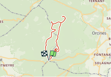
Trail Walking of 13.4 km to be discovered at Auvergne-Rhône-Alpes, Puy-de-Dôme, Ceyssat. This trail is proposed by dauzata.

Description

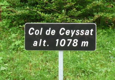
Départ du Col de Ceyssat. Puy-de-Dôme, Pariou et Cliersou.
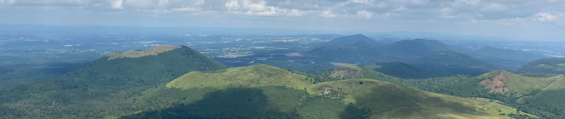
Le roi de la région est omniprésent.

Elevation profile

Photos

27 photos in total. Please click on a photo to see them all in the gallery.

Positioning

Country:
France
Region :
Auvergne-Rhône-Alpes
Department/Province :
Puy-de-Dôme
Municipality :
Ceyssat
Location:
Unknown
Start:(UTM)
496536 ; 5067840 (31T) N.

Trails nearby

Trail Walking Orcines - Ceyssat_Puy_Dome - Photo
Walking
GUIDE
jagarnier

Walking

Medium
(2)
Orcines, Auvergne-Rhône-Alpes, Puy-de-Dôme, France
7.3 km | 12.3 km-effort
2h 31min
Yes
Trail Walking Orcines - Puy de Pariou - Photo
Walking
Rodolphe1508

Walking

Medium
(1)
Orcines, Auvergne-Rhône-Alpes, Puy-de-Dôme, France
8.6 km | 12.4 km-effort
3h 7min
Yes
Trail Walking Orcines - Le tour du Puy de Dôme - Photo
Walking
tracegps

Walking

Difficult
(1)
Orcines, Auvergne-Rhône-Alpes, Puy-de-Dôme, France
12.2 km | 17.3 km-effort
3h 0min
Yes
Trail Walking Orcines - Le Puy de Montrodeix par Orcines - Photo
Walking
tracegps

Walking

Difficult
(1)
Orcines, Auvergne-Rhône-Alpes, Puy-de-Dôme, France
11.1 km | 14.5 km-effort
3h 30min
Yes
Trail On foot Ceyssat - Le Puy de Dôme - Photo
On foot
GUIDE+

On foot

Easy
Ceyssat, Auvergne-Rhône-Alpes, Puy-de-Dôme, France
7 km | 12 km-effort
2h 44min
Yes
Trail On foot Saint-Genès-Champanelle - Mazaye / Laschamp - Photo
On foot
GUIDE+

On foot

Medium
Saint-Genès-Champanelle, Auvergne-Rhône-Alpes, Puy-de-Dôme, France
21 km | 30 km-effort
6h 46min
No
Trail On foot Orcines - Le Tour du Puy de Dome - Photo
On foot
GUIDE+

On foot

Easy
Orcines, Auvergne-Rhône-Alpes, Puy-de-Dôme, France
9.4 km | 12.8 km-effort
2h 54min
Yes
Trail On foot Orcines - Le Puy de Montrodeix - Photo
On foot
GUIDE+

On foot

Easy
Orcines, Auvergne-Rhône-Alpes, Puy-de-Dôme, France
12 km | 15.5 km-effort
3h 31min
No
Trail Mountain bike Saint-Ours - Chambois  - Photo
Mountain bike
Halberstadt

Mountain bike

(1)
Saint-Ours, Auvergne-Rhône-Alpes, Puy-de-Dôme, France
27 km | 33 km-effort
2h 29min
Yes


Close
My subscriptions