Trail On foot Estoher - Le Canigou etape 1 par GR 10 - Photo

Le Canigou etape 1 par GR 10

© OpenStreetMap contributors
Length
Length
8 km
Max alt
Max alt
2158 m
Uphill gradient
Uphill gradient
783 m
Km-Effort
Km-Effort  
15.9 km
Min alt
Min alt
1380 m
Downhill gradient
Downhill gradient
13 m
Boucle
Boucle
No
Creation date :
2021-07-27 12:05:47.676
Updated on :
2021-07-27 12:43:30.973

(0 Reviews)

On foot
On foot
3h10
Difficulty : Difficult

Scan this QR Code to open this trail in the SityTrail application

FREE GPS app for hiking

Logo SityTrail SityTrail

IGN / Geographical institutes

Download SityTrail from the App Store Download SityTrail from Google Play

Logo SityTrail SityTrail World

The world is yours!

Download SityTrail from the App Store Download SityTrail from Google Play Download SityTrail on Huawei AppGallery

About

Trail On foot of 8 km to be discovered at Occitania, Pyrénées-Orientales, Estoher. This trail is proposed by Marc Auger.

Description

Départ du parking d'Esquena d'Ase - Refuge des Cortalets.

Elevation profile

Positioning

Country:
France
Region :
Occitania
Department/Province :
Pyrénées-Orientales
Municipality :
Estoher
Location:
Unknown
Start:(UTM)
458441 ; 4710912 (31T) N.

Trails nearby

Trail Walking Taurinya - Pic du Canigou par le refuge des Cortalets - Photo
Walking
tracegps

Walking

Very difficult
(4)
Taurinya, Occitania, Pyrénées-Orientales, France
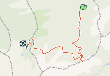
7.8 km | 17.6 km-effort
6h 30min
Yes
Trail On foot Valmanya - Tour del Canigó - Photo
On foot
GUIDE+

On foot

Very difficult
Valmanya, Occitania, Pyrénées-Orientales, France
63 km | 113 km-effort
25h 42min
Yes
Trail Walking Clara-Villerach - clara villerach parking du Liech Lcara - Photo
Walking
bouardlaurent

Walking

Medium
Clara-Villerach, Occitania, Pyrénées-Orientales, France
9.6 km | 14.2 km-effort
2h 54min
Yes
Trail Walking Baillestavy - 20221127 Baillestavy- Valmanya - - Prat Mitja - Photo
Walking
ThonyM

Walking

Difficult
Baillestavy, Occitania, Pyrénées-Orientales, France
16.8 km | 30 km-effort
5h 2min
Yes
Trail Walking Taurinya - Jour 3 Pic du Canigou  - Photo
Walking
jacques delaporte

Walking

Difficult
Taurinya, Occitania, Pyrénées-Orientales, France
9.4 km | 16.1 km-effort
4h 29min
No
Trail Walking Taurinya - 2022 TRANSPYRÉNÉENNE : refuge les Mariales le Canigou - les Cortalets - Refuge  Bardera - Photo
Walking
LEGUE

Walking

Very difficult
Taurinya, Occitania, Pyrénées-Orientales, France
18.1 km | 27 km-effort
4h 5min
No
Trail Walking Baillestavy - 20220519 Ballestavy - Photo
Walking
ThonyM

Walking

Medium
Baillestavy, Occitania, Pyrénées-Orientales, France
12.6 km | 21 km-effort
3h 28min
Yes
Trail Walking Estoher - 20220227 Mas Maler- Mines de la Coume - Photo
Walking
ThonyM

Walking

Difficult
Estoher, Occitania, Pyrénées-Orientales, France
15.2 km | 30 km-effort
5h 35min
Yes
Trail Walking Valmanya - Los Masos Prat Cabrera - Photo
Walking
oscar1

Walking

Very difficult
Valmanya, Occitania, Pyrénées-Orientales, France
12.6 km | 23 km-effort
3h 37min
Yes


Close
My subscriptions