Trail Walking Bussy-en-Othe - Bussy en Othe 210725 - Photo
 Specialized77
Specialized77

User GUIDE

© OpenStreetMap contributors
Length
Length
11.4 km
Max alt
Max alt
259 m
Uphill gradient
Uphill gradient
193 m
Km-Effort
Km-Effort  
13.9 km
Min alt
Min alt
152 m
Downhill gradient
Downhill gradient
193 m
Boucle
Boucle
Yes
Creation date :
2021-07-25 07:00:12.87
Updated on :
2024-09-13 21:02:57.229

(0 Reviews)

Walking
Walking
3h58
Difficulty : Easy

Scan this QR Code to open this trail in the SityTrail application

FREE GPS app for hiking

Logo SityTrail SityTrail

IGN / Geographical institutes

Download SityTrail from the App Store Download SityTrail from Google Play

Logo SityTrail SityTrail World

The world is yours!

Download SityTrail from the App Store Download SityTrail from Google Play Download SityTrail on Huawei AppGallery

About

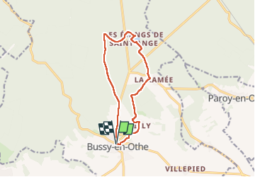
Trail Walking of 11.4 km to be discovered at Bourgogne-Franche-Comté, Yonne, Bussy-en-Othe. This trail is proposed by Specialized77.

Description

Avec Paron rebondir

Elevation profile

Photos

Positioning

Country:
France
Region :
Bourgogne-Franche-Comté
Department/Province :
Yonne
Municipality :
Bussy-en-Othe
Location:
Unknown
Start:(UTM)
538270 ; 5318589 (31U) N.

Trails nearby

Trail Walking Bussy-en-Othe - Bussy Les étangs de St Ange - Photo
Walking
papyjv8991

Walking

Easy
Bussy-en-Othe, Bourgogne-Franche-Comté, Yonne, France
7.2 km | 8.3 km-effort
1h 49min
Yes
Trail Walking Bussy-en-Othe - st ange - Photo
Walking
c.chehere

Walking

Very easy
Bussy-en-Othe, Bourgogne-Franche-Comté, Yonne, France
3.4 km | 3.9 km-effort
1h 13min
No
Trail Walking Bussy-en-Othe - 3 mai - Photo
Walking
c.chehere

Walking

Very easy
Bussy-en-Othe, Bourgogne-Franche-Comté, Yonne, France
2.3 km | 2.6 km-effort
1h 13min
Yes


Close
My subscriptions