![](/images/other/stat-length.png)
![Trail Walking Menat - Menat_Bords_Sioule - Photo](https://media.geolcdn.com/t/1900/400/b8306ec2-f4fe-45cb-ab27-e1c01f25ef1e.jpg&format=pjpeg&maxdim=2)
Menat_Bords_Sioule
jagarnier
User GUIDE
![Length](/images/other/stat-length.png)
![Max alt](https://static1.geolcdn.com/siteimages/upload/files/1508320355ic_sort_altitude_max_24dp.png)
![Uphill gradient](https://static1.geolcdn.com/siteimages/upload/files/1508320355ic_sort_den_pos_24dp.png)
![Km-Effort](/images/other/stat-length.png)
![Min alt](https://static1.geolcdn.com/siteimages/upload/files/1508320355ic_sort_altitude_min_24dp.png)
![Downhill gradient](https://static1.geolcdn.com/siteimages/upload/files/1508320355ic_sort_den_neg_24dp.png)
![Boucle](https://static1.geolcdn.com/siteimages/upload/files/16400158638029165_repeat_loop_refresh_sync_direction_icon.png)
![Walking](https://static1.geolcdn.com/sitytour/trail-icons/101.png)
4h30
Difficulty : Medium
![Scan this QR Code to open this trail in the SityTrail application](https://capi.geolives.com/qq0zvz2zws4bq2lad0pu/sitytour/trails/2870903/qr.png?size=200)
FREE GPS app for hiking
About
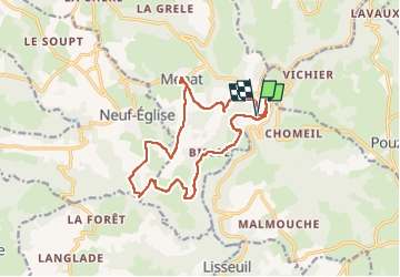
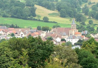
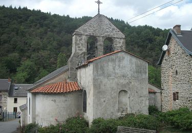
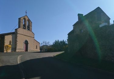
Trail Walking of 15 km to be discovered at Auvergne-Rhône-Alpes, Puy-de-Dôme, Menat. This trail is proposed by jagarnier.
Description
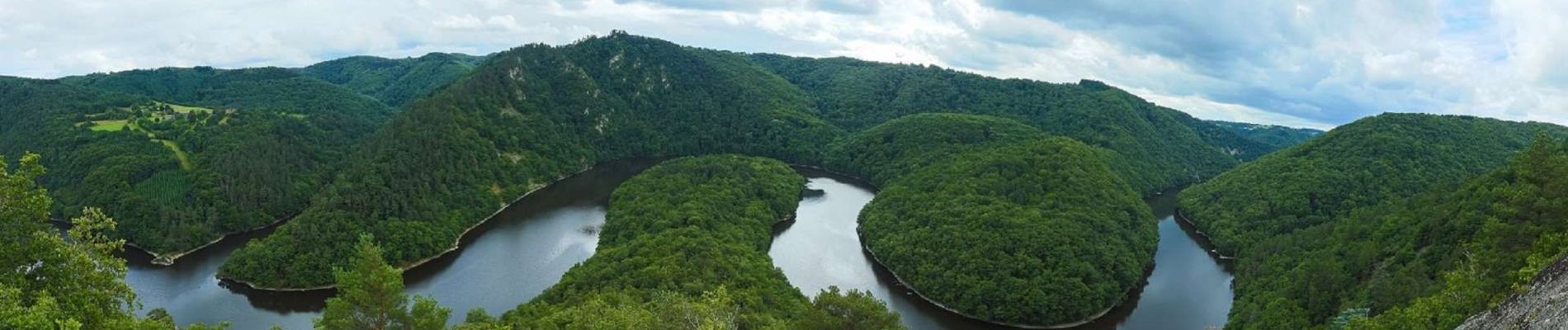
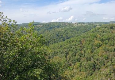
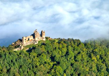
Les Gorges de la Sioule, splendides, escarpées, se déploient depuis le barrage de Queuille, jusqu'à Ébreuil. Succession de méandres qui serpentent le long de la rivière.
Les Gorges de la Sioule sont classées en ZNIEFF (Zone Naturelle d’Intérêt Ecologique, Floristique et Faunistique), et tout le bassin de la Sioule constitue une Zone Natura 2000.
Positioning
Comments
Trails nearby
![Trail Walking Pouzol - Gorges de la Sioule - Pouzol - Photo](https://media.geolcdn.com/t/375/260/ext.jpg?maxdim=2&url=https%3A%2F%2Fservices.sitytrail.com%2FGeolivesWS%2FDownloadMedia.ashx%3FTrailID%3D215198%26Media%3D15803_4.jpg)
![Walking Walking](https://static1.geolcdn.com/sitytour/trail-icons/101.png)
Walking
![](/images/other/stat-length.png)
![](https://static1.geolcdn.com/siteimages/upload/files/16400158638029165_repeat_loop_refresh_sync_direction_icon.png)
![Trail On foot Menat - Pont de Menat - Photo](https://media.geolcdn.com/t/375/260/29eef8b9-d9df-4c17-a011-beb17c77d9fe.jpeg&format=jpg&maxdim=2)
![On foot On foot](https://static1.geolcdn.com/sitytour/trail-icons/100.png)
On foot
![](/images/other/stat-length.png)
![](https://static1.geolcdn.com/siteimages/upload/files/16400158638029165_repeat_loop_refresh_sync_direction_icon.png)
![Trail On foot Menat - Servant - Photo](https://media.geolcdn.com/t/375/260/1573c00b-ea0c-4ff0-a6ed-84dd38907865.jpeg&format=jpg&maxdim=2)
![On foot On foot](https://static1.geolcdn.com/sitytour/trail-icons/100.png)
On foot
![](/images/other/stat-length.png)
![](https://static1.geolcdn.com/siteimages/upload/files/16400158638029165_repeat_loop_refresh_sync_direction_icon.png)
![Trail On foot Lisseuil - Lisseuil - Photo](https://media.geolcdn.com/t/375/260/5816c14b-dd3a-4f14-83b4-045502c6d651.jpeg&format=jpg&maxdim=2)
![On foot On foot](https://static1.geolcdn.com/sitytour/trail-icons/100.png)
On foot
![](/images/other/stat-length.png)
![](https://static1.geolcdn.com/siteimages/upload/files/16400158638029165_repeat_loop_refresh_sync_direction_icon.png)
![Trail On foot Saint-Rémy-de-Blot - Chateau-Rocher - Photo](https://media.geolcdn.com/t/375/260/b4e40603-7f2c-4069-952e-528bc9ebae62.jpeg&format=jpg&maxdim=2)
![On foot On foot](https://static1.geolcdn.com/sitytour/trail-icons/100.png)
On foot
![](/images/other/stat-length.png)
![](https://static1.geolcdn.com/siteimages/upload/files/16400158638029165_repeat_loop_refresh_sync_direction_icon.png)
![Trail Walking Pouzol - Vallée de Chouvigny - Photo](https://media.geolcdn.com/t/375/260/cae2d1a6-ef24-46ee-b4d8-507f5b7c4049.jpg&format=jpg&maxdim=2)
![Walking Walking](https://static1.geolcdn.com/sitytour/trail-icons/101.png)
Walking
![](/images/other/stat-length.png)
![](https://static1.geolcdn.com/siteimages/upload/files/16400158638029165_repeat_loop_refresh_sync_direction_icon.png)
![Trail Walking Lisseuil - Lisseuil_Chateau_Rocher - Photo](https://media.geolcdn.com/t/375/260/d16a416c-06fd-4b71-8673-2d1f708bade4.jpg&format=jpg&maxdim=2)
![Walking Walking](https://static1.geolcdn.com/sitytour/trail-icons/101.png)
Walking
![](/images/other/stat-length.png)
![](https://static1.geolcdn.com/siteimages/upload/files/16400158638029165_repeat_loop_refresh_sync_direction_icon.png)
![Trail Walking Chouvigny - La table de peraclos - Photo](https://media.geolcdn.com/t/375/260/ab1c16a3-cd39-481c-bd66-f85c8e4c96ab.jpg&format=jpg&maxdim=2)
![Walking Walking](https://static1.geolcdn.com/sitytour/trail-icons/101.png)
Walking
![](/images/other/stat-length.png)
![](https://static1.geolcdn.com/siteimages/upload/files/16400158638029165_repeat_loop_refresh_sync_direction_icon.png)
![Trail On foot Ayat-sur-Sioule - Ruisseau de Bort - Photo](https://media.geolcdn.com/t/375/260/ext.jpg?maxdim=2&url=https%3A%2F%2Fstatic1.geolcdn.com%2Fsiteimages%2Fupload%2Ffiles%2F1545311037marcheuse_200dpi.jpg)
![On foot On foot](https://static1.geolcdn.com/sitytour/trail-icons/100.png)
On foot
![](/images/other/stat-length.png)
![](https://static1.geolcdn.com/siteimages/upload/files/16400158638029165_repeat_loop_refresh_sync_direction_icon.png)