Trail Mountain bike Sancey - Sancey-Surmont-Belvédère du Dard - Photo

Sancey-Surmont-Belvédère du Dard

© OpenStreetMap contributors
Length
Length
26 km
Max alt
Max alt
732 m
Uphill gradient
Uphill gradient
720 m
Km-Effort
Km-Effort  
36 km
Min alt
Min alt
488 m
Downhill gradient
Downhill gradient
720 m
Boucle
Boucle
Yes
Creation date :
2021-07-22 08:35:10.241
Updated on :
2021-07-23 08:55:17.539

(0 Reviews)

Mountain bike
Mountain bike
23h29
Difficulty : Medium

Scan this QR Code to open this trail in the SityTrail application

FREE GPS app for hiking

Logo SityTrail SityTrail

IGN / Geographical institutes

Download SityTrail from the App Store Download SityTrail from Google Play

Logo SityTrail SityTrail World

The world is yours!

Download SityTrail from the App Store Download SityTrail from Google Play Download SityTrail on Huawei AppGallery

About

Trail Mountain bike of 26 km to be discovered at Bourgogne-Franche-Comté, Doubs, Sancey. This trail is proposed by Raphaël K.

Description

De beaux points de vues. Descente de Surmont vers Sancey pour les Vététistes confirmés.

Elevation profile

Photos

Positioning

Country:
France
Region :
Bourgogne-Franche-Comté
Department/Province :
Doubs
Municipality :
Sancey
Location:
Unknown
Start:(UTM)
317886 ; 5241659 (32T) N.

Trails nearby

Trail Mountain bike Sancey - Surmont-Sancey-Belvédère du Dar - Photo
Mountain bike
Raphaël K

Mountain bike

Difficult
Sancey, Bourgogne-Franche-Comté, Doubs, France
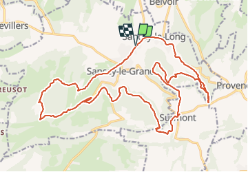
26 km | 36 km-effort
2h 36min
Yes
Trail Mountain bike Sancey - Belvoir-Sancey - Photo
Mountain bike
Raphaël K

Mountain bike

Difficult
Sancey, Bourgogne-Franche-Comté, Doubs, France
26 km | 35 km-effort
2h 21min
Yes
Trail Walking Sancey - Sancey - Photo
Walking
TRIMAILLE

Walking

Very easy
Sancey, Bourgogne-Franche-Comté, Doubs, France
21 km | 31 km-effort
6h 30min
Yes
Trail Walking Sancey - Belvoir - Photo
Walking
Papamoju

Walking

Easy
Sancey, Bourgogne-Franche-Comté, Doubs, France
11.4 km | 15.4 km-effort
3h 38min
Yes
Trail Walking Laviron - Circuit du Peu et de la Grotte - Doubs - Photo
Walking
tracegps

Walking

Difficult
Laviron, Bourgogne-Franche-Comté, Doubs, France
13 km | 18.3 km-effort
4h 0min
Yes
Trail Walking Sancey - Sancey  - Photo
Walking
mig26

Walking

Easy
Sancey, Bourgogne-Franche-Comté, Doubs, France
6.6 km | 9 km-effort
2h 13min
Yes
Trail Walking Sancey - sancey - surmont - Photo
Walking
eltonnermou

Walking

Medium
Sancey, Bourgogne-Franche-Comté, Doubs, France
12.6 km | 17.7 km-effort
1h 59min
Yes
Trail Walking Belvoir - Belvoir - Sancey - Photo
Walking
bmorel@orange.fr

Walking

Easy
Belvoir, Bourgogne-Franche-Comté, Doubs, France
10.9 km | 15.2 km-effort
Unknown
Yes
Trail Walking Belleherbe - belleherbe - Photo
Walking
cherlieu

Walking

Difficult
Belleherbe, Bourgogne-Franche-Comté, Doubs, France
22 km | 31 km-effort
8h 13min
Yes


Close
My subscriptions