![](/images/other/stat-length.png)
![Trail Walking Couëron - Nantes Lac de Beaulieu - Photo](https://media.geolcdn.com/t/1900/400/b93ef529-415a-406d-874d-d40c42a63c17.jpg&format=pjpeg&maxdim=2)
Nantes Lac de Beaulieu
jll7513
User
![Length](/images/other/stat-length.png)
Length
9.4 km
![Max alt](https://static1.geolcdn.com/siteimages/upload/files/1508320355ic_sort_altitude_max_24dp.png)
Max alt
44 m
![Uphill gradient](https://static1.geolcdn.com/siteimages/upload/files/1508320355ic_sort_den_pos_24dp.png)
Uphill gradient
105 m
![Km-Effort](/images/other/stat-length.png)
Km-Effort
10.8 km
![Min alt](https://static1.geolcdn.com/siteimages/upload/files/1508320355ic_sort_altitude_min_24dp.png)
Min alt
1 m
![Downhill gradient](https://static1.geolcdn.com/siteimages/upload/files/1508320355ic_sort_den_neg_24dp.png)
Downhill gradient
104 m
![Boucle](https://static1.geolcdn.com/siteimages/upload/files/16400158638029165_repeat_loop_refresh_sync_direction_icon.png)
Boucle
Yes
Creation date :
2021-07-23 05:11:28.0
Updated on :
2021-07-25 06:36:45.354
![Walking](https://static1.geolcdn.com/sitytour/trail-icons/101.png)
2h27
Difficulty : Easy
![Nordic walking](https://static1.geolcdn.com/sitytour/trail-icons/102.png)
1h46
Difficulty : Easy
![Scan this QR Code to open this trail in the SityTrail application](https://capi.geolives.com/qq0zvz2zws4bq2lad0pu/sitytour/trails/2870793/qr.png?size=200)
FREE GPS app for hiking
About
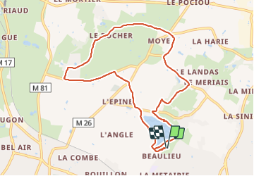
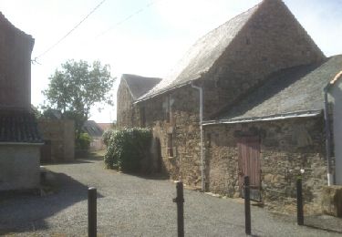
Trail Walking of 9.4 km to be discovered at Pays de la Loire, Loire-Atlantique, Couëron. This trail is proposed by jll7513.
Description
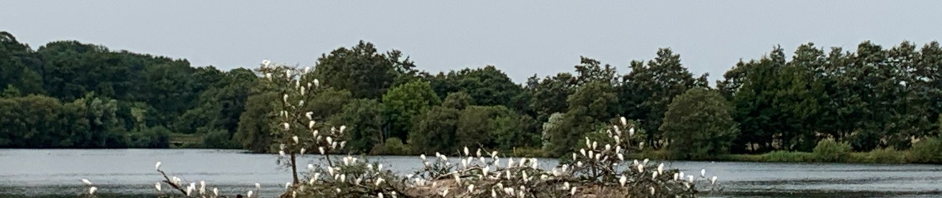
Départ et parking situé au bout d'un petit chemin de terre.Très beau parcours qui permet de faire le tour du lac, mais également de sillonner sur de très beaux sentiers. Très peu de route
Positioning
Country:
France
Region :
Pays de la Loire
Department/Province :
Loire-Atlantique
Municipality :
Couëron
Location:
Unknown
Start:(Dec)
Start:(UTM)
598679 ; 5230518 (30T) N.
Comments
Trails nearby
![Trail Bicycle tourism Le Pellerin - Activity - Photo](https://media.geolcdn.com/t/375/260/ext.jpg?maxdim=2&url=https%3A%2F%2Fstatic1.geolcdn.com%2Fsiteimages%2Fupload%2Ffiles%2F1524743154velo.jpg)
![Bicycle tourism Bicycle tourism](https://static1.geolcdn.com/sitytour/trail-icons/204.png)
Activity
Bicycle tourism
Very easy
(1)
Le Pellerin,
Pays de la Loire,
Loire-Atlantique,
France
![](/images/other/stat-length.png)
57 km | 62 km-effort
6h 0min
![](https://static1.geolcdn.com/siteimages/upload/files/16400158638029165_repeat_loop_refresh_sync_direction_icon.png)
No
![Trail Walking Sautron - Les vallées du Cens et de la Chézine - Photo](https://media.geolcdn.com/t/375/260/05a85b83-dbfa-4b32-96d1-505606f1e466.jpg&format=jpg&maxdim=2)
![Walking Walking](https://static1.geolcdn.com/sitytour/trail-icons/101.png)
Les vallées du Cens et de la Chézine
Walking
Medium
Sautron,
Pays de la Loire,
Loire-Atlantique,
France
![](/images/other/stat-length.png)
9.9 km | 11.4 km-effort
2h 4min
![](https://static1.geolcdn.com/siteimages/upload/files/16400158638029165_repeat_loop_refresh_sync_direction_icon.png)
Yes
![Trail On foot Bouguenais - La Roche Ballue - Photo](https://media.geolcdn.com/t/375/260/fe978ca7-737c-4da3-b5a6-561be870154c.jpeg&format=jpg&maxdim=2)
![On foot On foot](https://static1.geolcdn.com/sitytour/trail-icons/100.png)
La Roche Ballue
On foot
Easy
Bouguenais,
Pays de la Loire,
Loire-Atlantique,
France
![](/images/other/stat-length.png)
10.7 km | 12.2 km-effort
2h 47min
![](https://static1.geolcdn.com/siteimages/upload/files/16400158638029165_repeat_loop_refresh_sync_direction_icon.png)
Yes
![Trail Walking Couëron - boucle lac de beaulieu - Photo](https://media.geolcdn.com/t/375/260/ext.jpg?maxdim=2&url=https%3A%2F%2Fstatic1.geolcdn.com%2Fsiteimages%2Fupload%2Ffiles%2F1553511878bg_sport_marche.png)
![Walking Walking](https://static1.geolcdn.com/sitytour/trail-icons/101.png)
boucle lac de beaulieu
Walking
Very difficult
(1)
Couëron,
Pays de la Loire,
Loire-Atlantique,
France
![](/images/other/stat-length.png)
17.5 km | 19.6 km-effort
4h 34min
![](https://static1.geolcdn.com/siteimages/upload/files/16400158638029165_repeat_loop_refresh_sync_direction_icon.png)
Yes
![Trail Walking Indre - Les Îles d'Indre - Photo](https://media.geolcdn.com/t/375/260/ext.jpg?maxdim=2&url=https%3A%2F%2Fservices.sitytrail.com%2FGeolivesWS%2FDownloadMedia.ashx%3FTrailID%3D270167%26Media%3Dfix__20140425113327.jpg)
![Walking Walking](https://static1.geolcdn.com/sitytour/trail-icons/101.png)
Les Îles d'Indre
Walking
Easy
Indre,
Pays de la Loire,
Loire-Atlantique,
France
![](/images/other/stat-length.png)
13.6 km | 14.7 km-effort
3h 16min
![](https://static1.geolcdn.com/siteimages/upload/files/16400158638029165_repeat_loop_refresh_sync_direction_icon.png)
Yes
![Trail Walking Saint-Herblain - Saint Herblain, le marais et Tougas - Photo](https://media.geolcdn.com/t/375/260/ext.jpg?maxdim=2&url=https%3A%2F%2Fservices.sitytrail.com%2FGeolivesWS%2FDownloadMedia.ashx%3FTrailID%3D235051%26Media%3Dfix__20131130151512.jpg)
![Walking Walking](https://static1.geolcdn.com/sitytour/trail-icons/101.png)
Saint Herblain, le marais et Tougas
Walking
Very easy
Saint-Herblain,
Pays de la Loire,
Loire-Atlantique,
France
![](/images/other/stat-length.png)
4.9 km | 5.4 km-effort
1h 6min
![](https://static1.geolcdn.com/siteimages/upload/files/16400158638029165_repeat_loop_refresh_sync_direction_icon.png)
Yes
![Trail Walking Saint-Herblain - Saint Herblain bourg - Photo](https://media.geolcdn.com/t/375/260/ext.jpg?maxdim=2&url=https%3A%2F%2Fservices.sitytrail.com%2FGeolivesWS%2FDownloadMedia.ashx%3FTrailID%3D222196%26Media%3Dfix__20130920145704.jpg)
![Walking Walking](https://static1.geolcdn.com/sitytour/trail-icons/101.png)
Saint Herblain bourg
Walking
Easy
Saint-Herblain,
Pays de la Loire,
Loire-Atlantique,
France
![](/images/other/stat-length.png)
8.4 km | 9.6 km-effort
2h 3min
![](https://static1.geolcdn.com/siteimages/upload/files/16400158638029165_repeat_loop_refresh_sync_direction_icon.png)
Yes
![Trail Mountain bike Couëron - Balade VTT à Couéron - Photo](https://media.geolcdn.com/t/375/260/ext.jpg?maxdim=2&url=https%3A%2F%2Fservices.sitytrail.com%2FGeolivesWS%2FDownloadMedia.ashx%3FTrailID%3D215110%26Media%3D15694_6.jpg)
![Mountain bike Mountain bike](https://static1.geolcdn.com/sitytour/trail-icons/202.png)
Balade VTT à Couéron
Mountain bike
Medium
Couëron,
Pays de la Loire,
Loire-Atlantique,
France
![](/images/other/stat-length.png)
41 km | 46 km-effort
3h 30min
![](https://static1.geolcdn.com/siteimages/upload/files/16400158638029165_repeat_loop_refresh_sync_direction_icon.png)
Yes
![Trail Nordic walking Saint-Herblain - Gournerie - Photo](https://media.geolcdn.com/t/375/260/ext.jpg?maxdim=2&url=https%3A%2F%2Fstatic1.geolcdn.com%2Fsiteimages%2Fupload%2Ffiles%2F1545311037marcheuse_200dpi.jpg)
![Nordic walking Nordic walking](https://static1.geolcdn.com/sitytour/trail-icons/102.png)
Gournerie
Nordic walking
Easy
(1)
Saint-Herblain,
Pays de la Loire,
Loire-Atlantique,
France
![](/images/other/stat-length.png)
6.1 km | 7.1 km-effort
1h 7min
![](https://static1.geolcdn.com/siteimages/upload/files/16400158638029165_repeat_loop_refresh_sync_direction_icon.png)
Yes