![](/images/other/stat-length.png)
![Trail Walking Vallon-Pont-d'Arc - Ardèche - Photo](https://media.geolcdn.com/t/1900/400/112a2e65-f573-4d7e-91d4-97aa86530fb4.jpg&format=pjpeg&maxdim=2)
Ardèche
francq1976
User
![Length](/images/other/stat-length.png)
Length
7.6 km
![Max alt](https://static1.geolcdn.com/siteimages/upload/files/1508320355ic_sort_altitude_max_24dp.png)
Max alt
297 m
![Uphill gradient](https://static1.geolcdn.com/siteimages/upload/files/1508320355ic_sort_den_pos_24dp.png)
Uphill gradient
292 m
![Km-Effort](/images/other/stat-length.png)
Km-Effort
11.5 km
![Min alt](https://static1.geolcdn.com/siteimages/upload/files/1508320355ic_sort_altitude_min_24dp.png)
Min alt
83 m
![Downhill gradient](https://static1.geolcdn.com/siteimages/upload/files/1508320355ic_sort_den_neg_24dp.png)
Downhill gradient
295 m
![Boucle](https://static1.geolcdn.com/siteimages/upload/files/16400158638029165_repeat_loop_refresh_sync_direction_icon.png)
Boucle
No
Creation date :
2021-07-20 08:44:33.68
Updated on :
2021-07-20 12:49:35.85
![Walking](https://static1.geolcdn.com/sitytour/trail-icons/101.png)
3h06
Difficulty : Difficult
![Scan this QR Code to open this trail in the SityTrail application](https://capi.geolives.com/qq0zvz2zws4bq2lad0pu/sitytour/trails/2867746/qr.png?size=200)
FREE GPS app for hiking
About
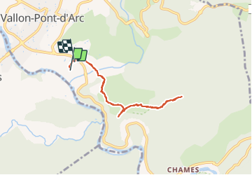
Trail Walking of 7.6 km to be discovered at Auvergne-Rhône-Alpes, Ardèche, Vallon-Pont-d'Arc. This trail is proposed by francq1976.
Description
guidance vocale pas au top...dommage de ne pas voir l'arc dans un angle de vue la perçant... néanmoins belle ballade physique en plus!
Positioning
Country:
France
Region :
Auvergne-Rhône-Alpes
Department/Province :
Ardèche
Municipality :
Vallon-Pont-d'Arc
Location:
Unknown
Start:(Dec)
Start:(UTM)
611481 ; 4916755 (31T) N.
Comments
Trails nearby
![Trail Walking Vallon-Pont-d'Arc - vallon-chastelas - Photo](https://media.geolcdn.com/t/375/260/ext.jpg?maxdim=2&url=https%3A%2F%2Fservices.sitytrail.com%2FGeolivesWS%2FDownloadMedia.ashx%3FTrailID%3D973164%26Media%3D6277a14a-7c60-41f6-8938-7b9c5dd03a0e.jpg)
![Walking Walking](https://static1.geolcdn.com/sitytour/trail-icons/101.png)
vallon-chastelas
Walking
Easy
(3)
Vallon-Pont-d'Arc,
Auvergne-Rhône-Alpes,
Ardèche,
France
![](/images/other/stat-length.png)
4.5 km | 6.2 km-effort
1h 19min
![](https://static1.geolcdn.com/siteimages/upload/files/16400158638029165_repeat_loop_refresh_sync_direction_icon.png)
Yes
![Trail Walking Labastide-de-Virac - 07 gorges ardeche - Photo](https://media.geolcdn.com/t/375/260/ext.jpg?maxdim=2&url=https%3A%2F%2Fstatic1.geolcdn.com%2Fsiteimages%2Fupload%2Ffiles%2F1553511878bg_sport_marche.png)
![Walking Walking](https://static1.geolcdn.com/sitytour/trail-icons/101.png)
07 gorges ardeche
Walking
Easy
(1)
Labastide-de-Virac,
Auvergne-Rhône-Alpes,
Ardèche,
France
![](/images/other/stat-length.png)
13.7 km | 22 km-effort
5h 5min
![](https://static1.geolcdn.com/siteimages/upload/files/16400158638029165_repeat_loop_refresh_sync_direction_icon.png)
Yes
![Trail Walking Vallon-Pont-d'Arc - 26 grottes deroc Chauvet zel - Photo](https://media.geolcdn.com/t/375/260/7f04590c-50bd-4ffc-b58f-87ccb5055b84.jpg&format=jpg&maxdim=2)
![Walking Walking](https://static1.geolcdn.com/sitytour/trail-icons/101.png)
26 grottes deroc Chauvet zel
Walking
Very difficult
Vallon-Pont-d'Arc,
Auvergne-Rhône-Alpes,
Ardèche,
France
![](/images/other/stat-length.png)
12.3 km | 20 km-effort
4h 39min
![](https://static1.geolcdn.com/siteimages/upload/files/16400158638029165_repeat_loop_refresh_sync_direction_icon.png)
No
![Trail Walking Labastide-de-Virac - les gorges de l'Ardèche - Photo](https://media.geolcdn.com/t/375/260/22a42236-31e2-4521-b8d2-19cd765eb1ce.jpg&format=jpg&maxdim=2)
![Walking Walking](https://static1.geolcdn.com/sitytour/trail-icons/101.png)
les gorges de l'Ardèche
Walking
Medium
Labastide-de-Virac,
Auvergne-Rhône-Alpes,
Ardèche,
France
![](/images/other/stat-length.png)
8.9 km | 14.1 km-effort
5h 14min
![](https://static1.geolcdn.com/siteimages/upload/files/16400158638029165_repeat_loop_refresh_sync_direction_icon.png)
Yes
![Trail Walking Vallon-Pont-d'Arc - Vallon pont d'arc au bivouac du gournier - Photo](https://media.geolcdn.com/t/375/260/086bf84f-df3e-4a5f-9662-b644951d7f29.jpg&format=jpg&maxdim=2)
![Walking Walking](https://static1.geolcdn.com/sitytour/trail-icons/101.png)
Vallon pont d'arc au bivouac du gournier
Walking
Medium
Vallon-Pont-d'Arc,
Auvergne-Rhône-Alpes,
Ardèche,
France
![](/images/other/stat-length.png)
18.8 km | 31 km-effort
3h 45min
![](https://static1.geolcdn.com/siteimages/upload/files/16400158638029165_repeat_loop_refresh_sync_direction_icon.png)
No
![Trail On foot Lagorce - 07 baravon 05.03.23 - Photo](https://media.geolcdn.com/t/375/260/18100b06-06c3-43e0-8df0-5f11b60408b1.jpg&format=jpg&maxdim=2)
![On foot On foot](https://static1.geolcdn.com/sitytour/trail-icons/100.png)
07 baravon 05.03.23
On foot
Easy
Lagorce,
Auvergne-Rhône-Alpes,
Ardèche,
France
![](/images/other/stat-length.png)
9.3 km | 14.2 km-effort
3h 13min
![](https://static1.geolcdn.com/siteimages/upload/files/16400158638029165_repeat_loop_refresh_sync_direction_icon.png)
Yes
![Mountain bike Mountain bike](https://static1.geolcdn.com/sitytour/trail-icons/202.png)
Vallon_Pont_d'Arc_20210712_092148
Mountain bike
Very easy
Vallon-Pont-d'Arc,
Auvergne-Rhône-Alpes,
Ardèche,
France
![](/images/other/stat-length.png)
27 km | 34 km-effort
Unknown
![](https://static1.geolcdn.com/siteimages/upload/files/16400158638029165_repeat_loop_refresh_sync_direction_icon.png)
Yes
![Trail Walking Salavas - 07 salavas pont de arc rieussec - Photo](https://media.geolcdn.com/t/375/260/187861b3-f925-444c-bb80-248c619c8cb5.jpg&format=jpg&maxdim=2)
![Walking Walking](https://static1.geolcdn.com/sitytour/trail-icons/101.png)
07 salavas pont de arc rieussec
Walking
Difficult
Salavas,
Auvergne-Rhône-Alpes,
Ardèche,
France
![](/images/other/stat-length.png)
16.4 km | 23 km-effort
7h 40min
![](https://static1.geolcdn.com/siteimages/upload/files/16400158638029165_repeat_loop_refresh_sync_direction_icon.png)
Yes
![Trail Walking Vallon-Pont-d'Arc - 07 grotte derocs chauvet - Photo](https://media.geolcdn.com/t/375/260/85789a19-d525-478e-9faa-7a8446c70e43.jpg&format=jpg&maxdim=2)
![Walking Walking](https://static1.geolcdn.com/sitytour/trail-icons/101.png)
07 grotte derocs chauvet
Walking
Difficult
Vallon-Pont-d'Arc,
Auvergne-Rhône-Alpes,
Ardèche,
France
![](/images/other/stat-length.png)
8.5 km | 14.5 km-effort
6h 18min
![](https://static1.geolcdn.com/siteimages/upload/files/16400158638029165_repeat_loop_refresh_sync_direction_icon.png)
Yes