Trail On foot Vailly - exp_19 juin 2021 à 08-23-55 - Photo

exp_19 juin 2021 à 08-23-55

© OpenStreetMap contributors
Length
Length
8.9 km
Max alt
Max alt
1877 m
Uphill gradient
Uphill gradient
819 m
Km-Effort
Km-Effort  
19.8 km
Min alt
Min alt
1438 m
Downhill gradient
Downhill gradient
815 m
Boucle
Boucle
Yes
Creation date :
2021-07-18 14:56:00.0
Updated on :
2021-07-18 14:58:44.757

(0 Reviews)

On foot
On foot
5h33
Difficulty : Difficult

Scan this QR Code to open this trail in the SityTrail application

FREE GPS app for hiking

Logo SityTrail SityTrail

IGN / Geographical institutes

Download SityTrail from the App Store Download SityTrail from Google Play

Logo SityTrail SityTrail World

The world is yours!

Download SityTrail from the App Store Download SityTrail from Google Play Download SityTrail on Huawei AppGallery

About

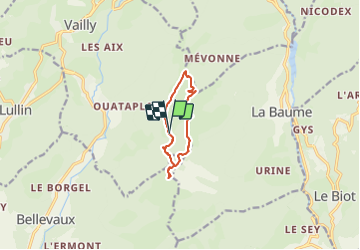
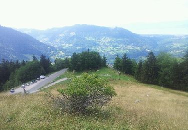
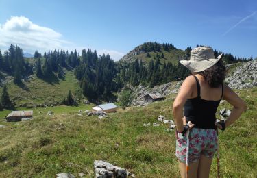
Trail On foot of 8.9 km to be discovered at Auvergne-Rhône-Alpes, Upper Savoy, Vailly. This trail is proposed by Myrostates.

Description

Boucle par le Mont Billiat puis les arrêtes direction la Pointe d'Ireuse.

Elevation profile

Positioning

Country:
France
Region :
Auvergne-Rhône-Alpes
Department/Province :
Upper Savoy
Municipality :
Vailly
Location:
Unknown
Start:(UTM)
313136 ; 5127814 (32T) N.

Trails nearby

Trail Walking La Vernaz - Pont du Diable - La Touvière - Lac du Jotty - Photo
Walking
GUIDE
Kargil

Walking

Difficult
La Vernaz, Auvergne-Rhône-Alpes, Upper Savoy, France
16.8 km | 29 km-effort
4h 49min
Yes
Trail Walking Vailly - Pointe d'Ireuse par les Nifflons - Photo
Walking
christophe7406

Walking

Difficult
(1)
Vailly, Auvergne-Rhône-Alpes, Upper Savoy, France
8.5 km | 16.9 km-effort
4h 0min
Yes
Trail Walking Bellevaux - Pointe d'Ireuse - Photo
Walking
DanElise

Walking

Medium
(2)
Bellevaux, Auvergne-Rhône-Alpes, Upper Savoy, France
11.3 km | 23 km-effort
5h 47min
Yes
Trail Running Bellevaux - Allobroges2016_BZH74 - Photo
Running
BZH74

Running

Very difficult
(1)
Bellevaux, Auvergne-Rhône-Alpes, Upper Savoy, France
59 km | 119 km-effort
12h 0min
Yes
Trail Walking Le Biot - La Pointe de la Croix depuis le Biot - Photo
Walking
thierry13710

Walking

Medium
Le Biot, Auvergne-Rhône-Alpes, Upper Savoy, France
19.3 km | 34 km-effort
7h 2min
Yes
Trail Running Bellevaux - Allobroges 63 - Photo
Running
BZH74

Running

Difficult
(1)
Bellevaux, Auvergne-Rhône-Alpes, Upper Savoy, France
63 km | 127 km-effort
14h 0min
Yes
Trail Snowshoes Bellevaux - vers tres le saix - Photo
Snowshoes
michelpratesi

Snowshoes

Medium
(1)
Bellevaux, Auvergne-Rhône-Alpes, Upper Savoy, France
7.2 km | 13.1 km-effort
4h 18min
No
Trail Walking La Forclaz - col de tréchaussée - Photo
Walking
jntoreau

Walking

Medium
La Forclaz, Auvergne-Rhône-Alpes, Upper Savoy, France
6.6 km | 12.2 km-effort
2h 15min
Yes
Trail Walking Vailly - ireuse - Photo
Walking
PierreBellevaux

Walking

Very easy
Vailly, Auvergne-Rhône-Alpes, Upper Savoy, France
6.8 km | 13.1 km-effort
2h 31min
Yes


Close
My subscriptions