Trail Road bike Saint-Cyr-sur-Mer - ceyreste cuges - Photo
© OpenStreetMap contributors
Length
Length
53 km
Max alt
Max alt
422 m
Uphill gradient
Uphill gradient
858 m
Km-Effort
Km-Effort  
64 km
Min alt
Min alt
4 m
Downhill gradient
Downhill gradient
858 m
Boucle
Boucle
Yes
Creation date :
2021-07-10 07:21:43.841
Updated on :
2021-07-10 10:50:47.182

(0 Reviews)

Road bike
Road bike
3h14
Difficulty : Medium

Scan this QR Code to open this trail in the SityTrail application

FREE GPS app for hiking

Logo SityTrail SityTrail

IGN / Geographical institutes

Download SityTrail from the App Store Download SityTrail from Google Play

Logo SityTrail SityTrail World

The world is yours!

Download SityTrail from the App Store Download SityTrail from Google Play Download SityTrail on Huawei AppGallery

About

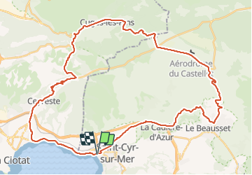
Trail Road bike of 53 km to be discovered at Provence-Alpes-Côte d'Azur, Var, Saint-Cyr-sur-Mer. This trail is proposed by christianlafon83@gmail.com.

Elevation profile

Positioning

Country:
France
Region :
Provence-Alpes-Côte d'Azur
Department/Province :
Var
Municipality :
Saint-Cyr-sur-Mer
Location:
Unknown
Start:(UTM)
718827 ; 4784307 (31T) N.

Trails nearby

Trail Walking Bandol - SityTrail - fregate - Photo
Walking
GUIDE
affinetataille

Walking

Easy
(1)
Bandol, Provence-Alpes-Côte d'Azur, Var, France
8.7 km | 11.4 km-effort
3h 15min
Yes
Trail Walking Ceyreste - Autour du Montounier 2eme version - Photo
Walking
GUIDE
affinetataille

Walking

Medium
(1)
Ceyreste, Provence-Alpes-Côte d'Azur, Bouches-du-Rhône, France
15.7 km | 24 km-effort
6h 0min
Yes
Trail Walking Bandol - SityTrail - Tour du golf de la Fregate (version longue ) - Photo
Walking
GUIDE
affinetataille

Walking

Very difficult
(1)
Bandol, Provence-Alpes-Côte d'Azur, Var, France
13.5 km | 19 km-effort
4h 19min
Yes
Trail Walking Saint-Cyr-sur-Mer - St Cyr  - Bandol - Photo
Walking
kephas

Walking

Medium
(1)
Saint-Cyr-sur-Mer, Provence-Alpes-Côte d'Azur, Var, France
16.1 km | 21 km-effort
4h 53min
No
Trail Walking Saint-Cyr-sur-Mer - Port d'Alon - Bandol - Port d'Alon - Photo
Walking
tracegps

Walking

Medium
(1)
Saint-Cyr-sur-Mer, Provence-Alpes-Côte d'Azur, Var, France
7.7 km | 9.9 km-effort
2h 0min
Yes
Trail Walking Saint-Cyr-sur-Mer - Le Port d'Alon - Photo
Walking
tracegps

Walking

Medium
(2)
Saint-Cyr-sur-Mer, Provence-Alpes-Côte d'Azur, Var, France
9.4 km | 12.8 km-effort
3h 0min
Yes
Trail Walking Bandol - Rando Bandol - Port d'Alon - Bandol - Photo
Walking
tracegps

Walking

Difficult
(1)
Bandol, Provence-Alpes-Côte d'Azur, Var, France
7.2 km | 9.4 km-effort
2h 30min
Yes
Trail Nordic walking La Cadière-d'Azur - 20220329_La Cadière d'Azur - Photo
Nordic walking
Marcsaintcyr

Nordic walking

Very easy
(1)
La Cadière-d'Azur, Provence-Alpes-Côte d'Azur, Var, France
6.8 km | 8.6 km-effort
1h 30min
Yes
Trail Nordic walking La Cadière-d'Azur - 20220329_La Cadière d'Azur - Photo
Nordic walking
Marcsaintcyr

Nordic walking

Very easy
(1)
La Cadière-d'Azur, Provence-Alpes-Côte d'Azur, Var, France
6.8 km | 8.6 km-effort
1h 30min
Yes


Close
My subscriptions