Trail Walking Thuillières - relange - Photo
 BOUTON
BOUTON

User

© OpenStreetMap contributors
Length
Length
8.8 km
Max alt
Max alt
396 m
Uphill gradient
Uphill gradient
199 m
Km-Effort
Km-Effort  
11.4 km
Min alt
Min alt
299 m
Downhill gradient
Downhill gradient
204 m
Boucle
Boucle
Yes
Creation date :
2021-07-08 12:52:00.182
Updated on :
2021-07-08 15:58:35.465

(1 Reviews)

Walking
Walking
2h32
Difficulty : Easy

Scan this QR Code to open this trail in the SityTrail application

FREE GPS app for hiking

Logo SityTrail SityTrail

IGN / Geographical institutes

Download SityTrail from the App Store Download SityTrail from Google Play

Logo SityTrail SityTrail World

The world is yours!

Download SityTrail from the App Store Download SityTrail from Google Play Download SityTrail on Huawei AppGallery

About

Trail Walking of 8.8 km to be discovered at Grand Est, Vosges, Thuillières. This trail is proposed by BOUTON.

Elevation profile

Positioning

Country:
France
Region :
Grand Est
Department/Province :
Vosges
Municipality :
Thuillières
Location:
Unknown
Start:(UTM)
278826 ; 5334290 (32U) N.

Comments

Please log in to post a review or rate the element


deux difficultés majeure : trouver l'endroit pour passer la rivière et après la deuxième traversee de la D18, comment contourner le paturage.


Trails nearby

Trail Walking Darney - Darney : Vers le pont Tatal  - Photo
Walking
ABICHE

Walking

Very easy
Darney, Grand Est, Vosges, France
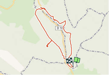
16.8 km | 21 km-effort
5h 8min
Yes
Trail Walking Belrupt - Sentier Le Val de Saône - Belrupt - Photo
Walking
tracegps

Walking

Medium
Belrupt, Grand Est, Vosges, France
11.1 km | 13 km-effort
2h 45min
Yes
Trail Walking Darney - Les terrasses de Darney - Photo
Walking
tracegps

Walking

Medium
Darney, Grand Est, Vosges, France
10.7 km | 13.1 km-effort
2h 45min
Yes
Trail Walking Dommartin-lès-Vallois - Sentier des vergers des Monts Faucilles -   Dommartin lès Vallois - Photo
Walking
tracegps

Walking

Difficult
Dommartin-lès-Vallois, Grand Est, Vosges, France
15.6 km | 20 km-effort
4h 0min
Yes
Trail Walking Darney - Les terrasses de Darney - Photo
Walking
tracegps

Walking

Easy
Darney, Grand Est, Vosges, France
7.2 km | 9.2 km-effort
1h 49min
Yes
Trail Walking Darney - qsdgg - Photo
Walking
BOUTON

Walking

Easy
Darney, Grand Est, Vosges, France
5 km | 5.7 km-effort
18min
No
Trail Walking Bonvillet - Bonvillet - Photo
Walking
fra_depoorter

Walking

Medium
Bonvillet, Grand Est, Vosges, France
11.5 km | 14.2 km-effort
2h 58min
Yes
Trail Walking Darney - Barcan  - Photo
Walking
BOUTON

Walking

Very easy
Darney, Grand Est, Vosges, France
9.4 km | 11.4 km-effort
2h 20min
Yes
Trail Walking Darney - DARNEY  - Photo
Walking
BOUTON

Walking

Very easy
Darney, Grand Est, Vosges, France
10.1 km | 12.4 km-effort
2h 41min
Yes


Close
My subscriptions