![](/images/other/stat-length.png)
![Trail Mountain bike Puygiron - PIERRE ROUSSE-Puygiron - Photo](https://media.geolcdn.com/t/1900/400/ext.pjpeg?maxdim=2&url=https%3A%2F%2Fstatic1.geolcdn.com%2Fsiteimages%2Fupload%2Ffiles%2F1524743154velo.jpg)
PIERRE ROUSSE-Puygiron
charlytan
User
![Length](/images/other/stat-length.png)
Length
12.4 km
![Max alt](https://static1.geolcdn.com/siteimages/upload/files/1508320355ic_sort_altitude_max_24dp.png)
Max alt
265 m
![Uphill gradient](https://static1.geolcdn.com/siteimages/upload/files/1508320355ic_sort_den_pos_24dp.png)
Uphill gradient
236 m
![Km-Effort](/images/other/stat-length.png)
Km-Effort
15.5 km
![Min alt](https://static1.geolcdn.com/siteimages/upload/files/1508320355ic_sort_altitude_min_24dp.png)
Min alt
149 m
![Downhill gradient](https://static1.geolcdn.com/siteimages/upload/files/1508320355ic_sort_den_neg_24dp.png)
Downhill gradient
238 m
![Boucle](https://static1.geolcdn.com/siteimages/upload/files/16400158638029165_repeat_loop_refresh_sync_direction_icon.png)
Boucle
Yes
Creation date :
2021-07-08 14:04:26.317
Updated on :
2021-08-20 12:01:27.262
![Mountain bike](https://static1.geolcdn.com/sitytour/trail-icons/202.png)
--
Difficulty : Unknown
![Scan this QR Code to open this trail in the SityTrail application](https://capi.geolives.com/qq0zvz2zws4bq2lad0pu/sitytour/trails/2853921/qr.png?size=200)
FREE GPS app for hiking
About
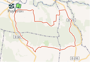
Trail Mountain bike of 12.4 km to be discovered at Auvergne-Rhône-Alpes, Drôme, Puygiron. This trail is proposed by charlytan.
Description
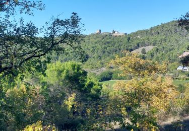
Commencez ce circuit au coeur de Puygiron où est niché un château du XIIe siècle classé. Un belvédère de choix, surplombant la plaine de la Valdaine et les anciennes ruelles du village. Poursuivez par de petits sentiers en forêts, ombragés et paisibles.
Positioning
Country:
France
Region :
Auvergne-Rhône-Alpes
Department/Province :
Drôme
Municipality :
Puygiron
Location:
Unknown
Start:(Dec)
Start:(UTM)
646809 ; 4933800 (31T) N.
Comments
Trails nearby
![Trail Walking Espeluche - 2022-10-20_15h14m37_GPX-Bois-Jamot-Espeluche - Photo](https://media.geolcdn.com/t/375/260/799cda92-0993-44e5-bfc9-d42f9f871bf2.jpg&format=jpg&maxdim=2)
![Walking Walking](https://static1.geolcdn.com/sitytour/trail-icons/101.png)
2022-10-20_15h14m37_GPX-Bois-Jamot-Espeluche
Walking
Medium
(1)
Espeluche,
Auvergne-Rhône-Alpes,
Drôme,
France
![](/images/other/stat-length.png)
11.3 km | 15.4 km-effort
3h 28min
![](https://static1.geolcdn.com/siteimages/upload/files/16400158638029165_repeat_loop_refresh_sync_direction_icon.png)
Yes
![Trail Walking Portes-en-Valdaine - 2022-10-01_17h32m32_13243364-1 - Photo](https://media.geolcdn.com/t/375/260/2ea09867-c31b-46c1-94ae-201697a2583c.jpg&format=jpg&maxdim=2)
![Walking Walking](https://static1.geolcdn.com/sitytour/trail-icons/101.png)
2022-10-01_17h32m32_13243364-1
Walking
Medium
(1)
Portes-en-Valdaine,
Auvergne-Rhône-Alpes,
Drôme,
France
![](/images/other/stat-length.png)
9.8 km | 13.6 km-effort
3h 2min
![](https://static1.geolcdn.com/siteimages/upload/files/16400158638029165_repeat_loop_refresh_sync_direction_icon.png)
Yes
![Trail Walking Rochefort-en-Valdaine - Rochefort-en-Valdaine Le Janeston 7km5 - Photo](https://media.geolcdn.com/t/375/260/c37954dd-2a13-465c-a79c-9622f5a3d882.jpg&format=jpg&maxdim=2)
![Walking Walking](https://static1.geolcdn.com/sitytour/trail-icons/101.png)
Rochefort-en-Valdaine Le Janeston 7km5
Walking
Medium
(1)
Rochefort-en-Valdaine,
Auvergne-Rhône-Alpes,
Drôme,
France
![](/images/other/stat-length.png)
7.3 km | 10.3 km-effort
2h 23min
![](https://static1.geolcdn.com/siteimages/upload/files/16400158638029165_repeat_loop_refresh_sync_direction_icon.png)
Yes
![Trail Walking Saint-Gervais-sur-Roubion - 2022-10-01_17h25m59_GPX-Moutette-St-Rome-STGervais - Photo](https://media.geolcdn.com/t/375/260/6b20cd10-00dc-411b-8b77-04281c5b5149.jpg&format=jpg&maxdim=2)
![Walking Walking](https://static1.geolcdn.com/sitytour/trail-icons/101.png)
2022-10-01_17h25m59_GPX-Moutette-St-Rome-STGervais
Walking
Medium
(1)
Saint-Gervais-sur-Roubion,
Auvergne-Rhône-Alpes,
Drôme,
France
![](/images/other/stat-length.png)
9.9 km | 11.9 km-effort
2h 43min
![](https://static1.geolcdn.com/siteimages/upload/files/16400158638029165_repeat_loop_refresh_sync_direction_icon.png)
Yes
![Trail Walking Portes-en-Valdaine - GPX-Rando-Plaine-Portoise-nouvelleversion - Photo](https://media.geolcdn.com/t/375/260/521ae53d-ced6-46fa-9655-4eb3952c25ee.jpg&format=jpg&maxdim=2)
![Walking Walking](https://static1.geolcdn.com/sitytour/trail-icons/101.png)
GPX-Rando-Plaine-Portoise-nouvelleversion
Walking
Easy
(1)
Portes-en-Valdaine,
Auvergne-Rhône-Alpes,
Drôme,
France
![](/images/other/stat-length.png)
7.1 km | 8.2 km-effort
2h 0min
![](https://static1.geolcdn.com/siteimages/upload/files/16400158638029165_repeat_loop_refresh_sync_direction_icon.png)
Yes
![Trail Walking Allan - allan transclavienne rac - Photo](https://media.geolcdn.com/t/375/260/ext.jpg?maxdim=2&url=https%3A%2F%2Fservices.sitytrail.com%2FGeolivesWS%2FDownloadMedia.ashx%3FTrailID%3D649381%26Media%3Dfix__20161022171755.jpg)
![Walking Walking](https://static1.geolcdn.com/sitytour/trail-icons/101.png)
allan transclavienne rac
Walking
Very easy
(1)
Allan,
Auvergne-Rhône-Alpes,
Drôme,
France
![](/images/other/stat-length.png)
19.1 km | 26 km-effort
5h 11min
![](https://static1.geolcdn.com/siteimages/upload/files/16400158638029165_repeat_loop_refresh_sync_direction_icon.png)
Yes
![Trail Walking La Touche - La Touche Crêtes de l'ysard 12km. - Photo](https://media.geolcdn.com/t/375/260/b7717e93-9def-4e5d-8328-3e96528d5925.jpg&format=jpg&maxdim=2)
![Walking Walking](https://static1.geolcdn.com/sitytour/trail-icons/101.png)
La Touche Crêtes de l'ysard 12km.
Walking
Difficult
(1)
La Touche,
Auvergne-Rhône-Alpes,
Drôme,
France
![](/images/other/stat-length.png)
12.1 km | 16.8 km-effort
3h 48min
![](https://static1.geolcdn.com/siteimages/upload/files/16400158638029165_repeat_loop_refresh_sync_direction_icon.png)
Yes
![Trail Mountain bike Puygiron - Puygiron VTT n°5 - Photo](https://media.geolcdn.com/t/375/260/ext.jpg?maxdim=2&url=https%3A%2F%2Fservices.sitytrail.com%2FGeolivesWS%2FDownloadMedia.ashx%3FTrailID%3D104845%26Media%3D8346_2.jpg)
![Mountain bike Mountain bike](https://static1.geolcdn.com/sitytour/trail-icons/202.png)
Puygiron VTT n°5
Mountain bike
Very difficult
(1)
Puygiron,
Auvergne-Rhône-Alpes,
Drôme,
France
![](/images/other/stat-length.png)
47 km | 60 km-effort
3h 0min
![](https://static1.geolcdn.com/siteimages/upload/files/16400158638029165_repeat_loop_refresh_sync_direction_icon.png)
Yes
![Trail Walking La Touche - La Touche : Les Citelles et Serre Pointu 12km - Photo](https://media.geolcdn.com/t/375/260/6be75cc0-9945-4cf3-b3f9-69a08db1d316.jpg&format=jpg&maxdim=2)
![Walking Walking](https://static1.geolcdn.com/sitytour/trail-icons/101.png)
La Touche : Les Citelles et Serre Pointu 12km
Walking
Difficult
La Touche,
Auvergne-Rhône-Alpes,
Drôme,
France
![](/images/other/stat-length.png)
12 km | 16.6 km-effort
4h 3min
![](https://static1.geolcdn.com/siteimages/upload/files/16400158638029165_repeat_loop_refresh_sync_direction_icon.png)
Yes