Trail Other activity Valdeblore - Saint Sauveur - Photo
© OpenStreetMap contributors
Length
Length
13.3 km
Max alt
Max alt
1291 m
Uphill gradient
Uphill gradient
592 m
Km-Effort
Km-Effort  
22 km
Min alt
Min alt
668 m
Downhill gradient
Downhill gradient
884 m
Boucle
Boucle
No
Creation date :
2014-12-10 00:00:00.0
Updated on :
2014-12-10 00:00:00.0

(0 Reviews)

Other activity
Other activity
4h18
Difficulty : Unknown

Scan this QR Code to open this trail in the SityTrail application

FREE GPS app for hiking

Logo SityTrail SityTrail

IGN / Geographical institutes

Download SityTrail from the App Store Download SityTrail from Google Play

Logo SityTrail SityTrail World

The world is yours!

Download SityTrail from the App Store Download SityTrail from Google Play Download SityTrail on Huawei AppGallery

About

Trail Other activity of 13.3 km to be discovered at Provence-Alpes-Côte d'Azur, Maritime Alps, Valdeblore. This trail is proposed by PEBREJOSIANE.

Description

Petite rando au départ de St Dalmas Valdeblore

Elevation profile

Photos

Positioning

Country:
France
Region :
Provence-Alpes-Côte d'Azur
Department/Province :
Maritime Alps
Municipality :
Valdeblore
Location:
Unknown
Start:(UTM)
353704 ; 4881998 (32T) N.

Trails nearby

Trail Walking Valdeblore - pepoiri  - Photo
Walking
REYPatrick

Walking

Very easy
(1)
Valdeblore, Provence-Alpes-Côte d'Azur, Maritime Alps, France
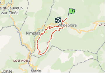
7.8 km | 16.3 km-effort
5h 31min
Yes
Trail On foot Rimplas - Circuit de la Couletta - Photo
On foot
GUIDE+

On foot

Easy
Rimplas, Provence-Alpes-Côte d'Azur, Maritime Alps, France
6.5 km | 11.9 km-effort
2h 42min
Yes
Trail On foot Valdeblore - Le Caïre Gros - Photo
On foot
GUIDE+

On foot

Medium
Valdeblore, Provence-Alpes-Côte d'Azur, Maritime Alps, France
9.8 km | 20 km-effort
4h 38min
Yes
Trail On foot Marie - Pointe de Clamia - Photo
On foot
GUIDE+

On foot

Easy
Marie, Provence-Alpes-Côte d'Azur, Maritime Alps, France
6.6 km | 12.5 km-effort
2h 50min
Yes
Trail Touring skiing Valdeblore - Pèpoiri et Petoumier - Photo
Touring skiing
GUIDE
nadd73

Touring skiing

Medium
Valdeblore, Provence-Alpes-Côte d'Azur, Maritime Alps, France
12.8 km | 31 km-effort
6h 44min
Yes
Trail Touring skiing Valdeblore - Mont Giraud - Photo
Touring skiing
GUIDE
nadd73

Touring skiing

Difficult
Valdeblore, Provence-Alpes-Côte d'Azur, Maritime Alps, France
15.7 km | 32 km-effort
7h 41min
Yes
Trail Touring skiing Valdeblore - Mont Petoumier. Mont Pépoiri - Photo
Touring skiing
GUIDE
nadd73

Touring skiing

Medium
Valdeblore, Provence-Alpes-Côte d'Azur, Maritime Alps, France
11.7 km | 27 km-effort
6h 45min
Yes
Trail Walking Valdeblore - Lacs des Millefonts de col du Barn au col Ferriere - Photo
Walking
GrouGary

Walking

Easy
Valdeblore, Provence-Alpes-Côte d'Azur, Maritime Alps, France
9.3 km | 17.2 km-effort
3h 54min
Yes
Trail Walking Valdeblore - St Dalmas Valdeblore  - Photo
Walking
Daniel Benteux

Walking

Easy
Valdeblore, Provence-Alpes-Côte d'Azur, Maritime Alps, France
8.7 km | 12.3 km-effort
2h 26min
Yes


Close
My subscriptions