Trail  Unknown - Hardangervidda-Norvege - Photo

Hardangervidda-Norvege

 PaulNord
PaulNord

User

© OpenStreetMap contributors
Length
Length
16.4 km
Max alt
Max alt
1596 m
Uphill gradient
Uphill gradient
426 m
Km-Effort
Km-Effort  
22 km
Min alt
Min alt
1214 m
Downhill gradient
Downhill gradient
414 m
Boucle
Boucle
No
Creation date :
2021-07-04 21:00:10.309
Updated on :
2022-01-23 17:00:48.01

(0 Reviews)


Scan this QR Code to open this trail in the SityTrail application

FREE GPS app for hiking

Logo SityTrail SityTrail

IGN / Geographical institutes

Download SityTrail from the App Store Download SityTrail from Google Play

Logo SityTrail SityTrail World

The world is yours!

Download SityTrail from the App Store Download SityTrail from Google Play Download SityTrail on Huawei AppGallery

About

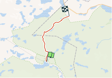
Trail of 16.4 km to be discovered at Vestland. This trail is proposed by PaulNord.

Description

Plateau du Hardangervidda.
Traces GPX des routes d'hiver 2017.
Waypoints des Hytta et abris d'urgence.

Elevation profile

Points of interest

Point of interest  - TUVA GARD priv - Photo
PaulNord
Point of interest  - Stigstuv - Photo
PaulNord
Point of interest  - Stavali self - Photo
PaulNord
Point of interest  - SANDHAUG GARD - Photo
PaulNord
Point of interest  - RÅSTUGU  ABR - Photo
PaulNord
Point of interest  - MURAN ABR - Photo
PaulNord
Point of interest  - Mosdalsbu self - Photo
PaulNord
Point of interest  - Middalsbu self - Photo
PaulNord
Point of interest  - MARBÚ GARD - Photo
PaulNord
Point of interest  - Lågaros self - Photo
PaulNord
Point of interest  - Lufsjå self - Photo
PaulNord
Point of interest  - LITLOS GARD - Photo
PaulNord
Point of interest  - KRÆKKJA GARD - Photo
PaulNord
Point of interest  - KROKAN  BAR - Photo
PaulNord
Point of interest  - KNUTSBU ABR - Photo
PaulNord
Point of interest  - KLEMSBU ABR - Photo
PaulNord
Point of interest  - Kjeldebu self - Photo
PaulNord
Point of interest  - BAKKEHYTTA  ABR - Photo
PaulNord

Positioning

Country:
Norway
Region :
Vestland
Department/Province :
Unknown
Municipality :
Unknown
Location:
Unknown
Start:(UTM)
418045 ; 6719391 (32V) N.

Trails nearby

Trail Walking  - Norway Hardangervidda - Photo
Walking
MathieuBourgois

Walking

Easy
, Vestland, , Norway
201 km | 280 km-effort
47min
No
Trail Mountain bike  - m-noorwegen-voss-rallarvegen - Photo
Mountain bike
gpstracks

Mountain bike

Very easy
, Vestland, , Norway
86 km | 119 km-effort
Unknown
No
Trail Walking  - w-noorwegen-hardangervida-skitour - Photo
Walking
gpstracks

Walking

Very easy
, Vestland, , Norway
118 km | 145 km-effort
Unknown
No
Trail Walking  - Finse naar Geiterygghytte - Photo
Walking
matthias.snoeckx

Walking

Difficult
, Vestland, , Norway
16.9 km | 24 km-effort
6h 46min
No
Trail Walking  - Finse à Varingfossen 2 jours - Photo
Walking
MathieuBourgois

Walking

Difficult
, Vestland, , Norway
54 km | 69 km-effort
14h 32min
No


Close
My subscriptions