Trail Walking Saint-Léger-sous-Cholet - Cholet 1 - Photo
© OpenStreetMap contributors
Length
Length
10.5 km
Max alt
Max alt
141 m
Uphill gradient
Uphill gradient
91 m
Km-Effort
Km-Effort  
11.7 km
Min alt
Min alt
108 m
Downhill gradient
Downhill gradient
91 m
Boucle
Boucle
Yes
Creation date :
2021-07-04 08:07:54.963
Updated on :
2021-07-04 10:38:46.949

(0 Reviews)

Walking
Walking
2h13
Difficulty : Very easy

Scan this QR Code to open this trail in the SityTrail application

FREE GPS app for hiking

Logo SityTrail SityTrail

IGN / Geographical institutes

Download SityTrail from the App Store Download SityTrail from Google Play

Logo SityTrail SityTrail World

The world is yours!

Download SityTrail from the App Store Download SityTrail from Google Play Download SityTrail on Huawei AppGallery

About

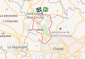
Trail Walking of 10.5 km to be discovered at Pays de la Loire, Maine-et-Loire, Saint-Léger-sous-Cholet. This trail is proposed by Marie Claire Lefort.

Elevation profile

Positioning

Country:
France
Region :
Pays de la Loire
Department/Province :
Maine-et-Loire
Municipality :
Saint-Léger-sous-Cholet
Location:
Unknown
Start:(UTM)
659111 ; 5217914 (30T) N.

Trails nearby

Trail Other activity Cholet - Cholet-Nantes - Photo
Other activity
st141230

Other activity

Very easy
(2)
Cholet, Pays de la Loire, Maine-et-Loire, France
78 km | 86 km-effort
Unknown
No
Trail Running Cholet - Autour de Cholet - Photo
Running
tracegps

Running

Medium
Cholet, Pays de la Loire, Maine-et-Loire, France
11.9 km | 13.5 km-effort
1h 15min
Yes
Trail Walking Cholet - Autour de Cholet - Photo
Walking
tracegps

Walking

Medium
Cholet, Pays de la Loire, Maine-et-Loire, France
11.9 km | 13.5 km-effort
2h 30min
Yes
Trail Mountain bike Le May-sur-Èvre -  La Randonnée De La Fressure - Photo
Mountain bike
tracegps

Mountain bike

Difficult
Le May-sur-Èvre, Pays de la Loire, Maine-et-Loire, France
53 km | 61 km-effort
3h 0min
Yes
Trail Mountain bike La Séguinière - La Séguinière 2023 - Photo
Mountain bike
pates_au_chaud

Mountain bike

Difficult
La Séguinière, Pays de la Loire, Maine-et-Loire, France
36 km | 42 km-effort
3h 54min
Yes
Trail Mountain bike La Séguinière - La Séguinière 2022 - Photo
Mountain bike
pates_au_chaud

Mountain bike

Difficult
La Séguinière, Pays de la Loire, Maine-et-Loire, France
32 km | 36 km-effort
2h 51min
Yes
Trail Walking La Séguinière - La Séguinière - Photo
Walking
Delgorge

Walking

Easy
La Séguinière, Pays de la Loire, Maine-et-Loire, France
10.9 km | 12.7 km-effort
2h 47min
Yes
Trail Walking La Séguinière - rando du bouchot 2013 - Photo
Walking
ghislaincouppey

Walking

Very easy
La Séguinière, Pays de la Loire, Maine-et-Loire, France
17.2 km | 20 km-effort
3h 6min
Yes
Trail Mountain bike Saint-Léger-sous-Cholet - Rando VTT St Leger sous Cholet - Photo
Mountain bike
laet

Mountain bike

Very easy
Saint-Léger-sous-Cholet, Pays de la Loire, Maine-et-Loire, France
39 km | 44 km-effort
1h 49min
Yes


Close
My subscriptions