


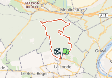

10.7 km | 13.8 km-effort

User


FREE GPS app for hiking
 SityTrail
IGN / Geographical institutes
SityTrail World
The world is yours!
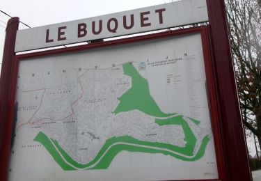
Trail Walking of 12.4 km to be discovered at Normandy, Seine-Maritime, La Londe. This trail is proposed by MichelRando7656.
Beau parcours très varié. De belles côtes et des descentes rapides. En cas de pluie, prévoir les batons. Très bonnes chaussures de randonnées nécessaires.
 "
data-pinterest-text="Pin it"
data-tweet-text="share on twitter"
data-facebook-share-url="https://www.sitytrail.com/en/trails/2848378-la-londe--la-londe-vers-le-pont-dxorleans/?photo=1#lg=1&slide=1"
data-twitter-share-url="https://www.sitytrail.com/en/trails/2848378-la-londe--la-londe-vers-le-pont-dxorleans/?photo=1#lg=1&slide=1"
data-googleplus-share-url="https://www.sitytrail.com/en/trails/2848378-la-londe--la-londe-vers-le-pont-dxorleans/?photo=1#lg=1&slide=1"
data-pinterest-share-url="https://www.sitytrail.com/en/trails/2848378-la-londe--la-londe-vers-le-pont-dxorleans/?photo=1#lg=1&slide=1">
"
data-pinterest-text="Pin it"
data-tweet-text="share on twitter"
data-facebook-share-url="https://www.sitytrail.com/en/trails/2848378-la-londe--la-londe-vers-le-pont-dxorleans/?photo=1#lg=1&slide=1"
data-twitter-share-url="https://www.sitytrail.com/en/trails/2848378-la-londe--la-londe-vers-le-pont-dxorleans/?photo=1#lg=1&slide=1"
data-googleplus-share-url="https://www.sitytrail.com/en/trails/2848378-la-londe--la-londe-vers-le-pont-dxorleans/?photo=1#lg=1&slide=1"
data-pinterest-share-url="https://www.sitytrail.com/en/trails/2848378-la-londe--la-londe-vers-le-pont-dxorleans/?photo=1#lg=1&slide=1">
 "
data-pinterest-text="Pin it"
data-tweet-text="share on twitter"
data-facebook-share-url="https://www.sitytrail.com/en/trails/2848378-la-londe--la-londe-vers-le-pont-dxorleans/?photo=2#lg=1&slide=2"
data-twitter-share-url="https://www.sitytrail.com/en/trails/2848378-la-londe--la-londe-vers-le-pont-dxorleans/?photo=2#lg=1&slide=2"
data-googleplus-share-url="https://www.sitytrail.com/en/trails/2848378-la-londe--la-londe-vers-le-pont-dxorleans/?photo=2#lg=1&slide=2"
data-pinterest-share-url="https://www.sitytrail.com/en/trails/2848378-la-londe--la-londe-vers-le-pont-dxorleans/?photo=2#lg=1&slide=2">
"
data-pinterest-text="Pin it"
data-tweet-text="share on twitter"
data-facebook-share-url="https://www.sitytrail.com/en/trails/2848378-la-londe--la-londe-vers-le-pont-dxorleans/?photo=2#lg=1&slide=2"
data-twitter-share-url="https://www.sitytrail.com/en/trails/2848378-la-londe--la-londe-vers-le-pont-dxorleans/?photo=2#lg=1&slide=2"
data-googleplus-share-url="https://www.sitytrail.com/en/trails/2848378-la-londe--la-londe-vers-le-pont-dxorleans/?photo=2#lg=1&slide=2"
data-pinterest-share-url="https://www.sitytrail.com/en/trails/2848378-la-londe--la-londe-vers-le-pont-dxorleans/?photo=2#lg=1&slide=2">
 "
data-pinterest-text="Pin it"
data-tweet-text="share on twitter"
data-facebook-share-url="https://www.sitytrail.com/en/trails/2848378-la-londe--la-londe-vers-le-pont-dxorleans/?photo=3#lg=1&slide=3"
data-twitter-share-url="https://www.sitytrail.com/en/trails/2848378-la-londe--la-londe-vers-le-pont-dxorleans/?photo=3#lg=1&slide=3"
data-googleplus-share-url="https://www.sitytrail.com/en/trails/2848378-la-londe--la-londe-vers-le-pont-dxorleans/?photo=3#lg=1&slide=3"
data-pinterest-share-url="https://www.sitytrail.com/en/trails/2848378-la-londe--la-londe-vers-le-pont-dxorleans/?photo=3#lg=1&slide=3">
"
data-pinterest-text="Pin it"
data-tweet-text="share on twitter"
data-facebook-share-url="https://www.sitytrail.com/en/trails/2848378-la-londe--la-londe-vers-le-pont-dxorleans/?photo=3#lg=1&slide=3"
data-twitter-share-url="https://www.sitytrail.com/en/trails/2848378-la-londe--la-londe-vers-le-pont-dxorleans/?photo=3#lg=1&slide=3"
data-googleplus-share-url="https://www.sitytrail.com/en/trails/2848378-la-londe--la-londe-vers-le-pont-dxorleans/?photo=3#lg=1&slide=3"
data-pinterest-share-url="https://www.sitytrail.com/en/trails/2848378-la-londe--la-londe-vers-le-pont-dxorleans/?photo=3#lg=1&slide=3">

Walking

Walking

Walking

Walking

Walking
Walking

Walking

Walking
Walking