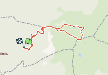
petit arc, variante
jibebouvier
User
Length
10.2 km
Max alt
2352 m
Uphill gradient
1208 m
Km-Effort
26 km
Min alt
1170 m
Downhill gradient
1209 m
Boucle
Yes
Creation date :
2021-07-03 06:10:05.854
Updated on :
2021-07-03 09:59:36.813
3h39
Difficulty : Difficult
FREE GPS app for hiking
About
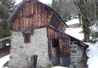
Trail Walking of 10.2 km to be discovered at Auvergne-Rhône-Alpes, Savoy, Bonvillaret. This trail is proposed by jibebouvier.
Description
par la route du fort de montperché, puis direction la platière, puis petit arc. retour à la Roots vers le col entre petit et grand arc côté bonvillard, attention pour expert !
Positioning
Country:
France
Region :
Auvergne-Rhône-Alpes
Department/Province :
Savoy
Municipality :
Bonvillaret
Location:
Unknown
Start:(Dec)
Start:(UTM)
291245 ; 5048803 (32T) N.
Comments
Trails nearby
Combe bronsin collu au Nord 2400
Touring skiing
Easy
Montsapey,
Auvergne-Rhône-Alpes,
Savoy,
France
10 km | 25 km-effort
4h 19min
No
La Thuile NO
Touring skiing
Medium
Notre-Dame-des-Millières,
Auvergne-Rhône-Alpes,
Savoy,
France
10.6 km | 26 km-effort
4h 32min
Yes
Mont Bellacha
Touring skiing
Difficult
Montsapey,
Auvergne-Rhône-Alpes,
Savoy,
France
8.9 km | 25 km-effort
4h 35min
Yes
Char de la Turche petit Arc
Touring skiing
Easy
Montsapey,
Auvergne-Rhône-Alpes,
Savoy,
France
11.2 km | 28 km-effort
6h 51min
Yes
pas de Freydon
Touring skiing
Medium
Montsapey,
Auvergne-Rhône-Alpes,
Savoy,
France
13.6 km | 34 km-effort
7h 37min
Yes
boucle NDMillières Aiton
Horseback riding
Very easy
(1)
Sainte-Hélène-sur-Isère,
Auvergne-Rhône-Alpes,
Savoy,
France
14.1 km | 16.3 km-effort
2h 30min
Yes
Grand Arc
Walking
Very difficult
(1)
Val-d'Arc,
Auvergne-Rhône-Alpes,
Savoy,
France
7.7 km | 28 km-effort
5h 0min
No
Pointe de Combe Bronsin par Tioulévé
Walking
Difficult
Montsapey,
Auvergne-Rhône-Alpes,
Savoy,
France
9.2 km | 23 km-effort
3h 58min
No
les batteries par Montgilbert
Walking
Easy
Montgilbert,
Auvergne-Rhône-Alpes,
Savoy,
France
11.5 km | 19.5 km-effort
3h 10min
Yes